- Home
- Project Apri sottomenù
- UPLAND ARCHAEOLOGY WORKSHOP Apri sottomenù
-
Abstracts
Apri sottomenù
- Wieke de Neef (Ghent University / Otto-Friedrich University Bamberg)
- Francesco Carrer (School of History, Classics and Archaeology, Newcastle University (UK))
- Umberto Tecchiati (University of Milan)
- Tesse Stek (KNIR - Royal Netherlands Institute in Rome)
- Riccardo Rao (University of Bergamo)
- Fabio Saggioro, Nicola Mancassola (University of Verona)
- Roberto Maggi, LASA (Laboratorio di Archeologia e Storia Ambientale), University of Genova
- Andrea Cardarelli, Andrea Conte (University of Rome "La Sapienza")
- Federico Zoni (University of Bergamo)
-
Short presentations
Apri sottomenù
- SHORT PRESENTATIONS PROGRAMME
- Putzolu et al., The 2nd Millennium BC in the northern Apennines
- Giorgi et al., New insights into the upland landscape of ancient Epirus, Southern Albania
- Carra, Subsistence economy in the Bronze Age in the northern Apennines upland
- Gaucci et al., Mapping mobility in the Apennines: The Reno Valley between the 6th-4th century BCE and the contemporary period
- Cirelli et al., Insediamenti di altura nell’Appennino Romagnolo e Toscano nel medioevo
- Betori et al., Amatrice: da castello a città
- Del Fattore, Upland landscapes and settlements strategies in the Central-Southern Apennines (1000 BC-2023 AD)
- Conversi et al., The site of Albareto cà Nova
- Bottazzi et al., Attorno al Monte Titano (739 m s.l.m.). Ricerche archeologiche e paleoambientali in Repubblica di San Marino
- Conversi et al., Il sito tardoatico – medievale d’altura della Piana di S. Martino , Pianello Val Tidone (PC)
- Cortesi et al., Archeologia dei paesaggi in una vallata appenninica: il progetto “Val Fantella” (Premilcuore, FC)
- Barbariol, Farms abandonment in Iceland
- Garattoni, Doss Penede (Nago, TN): progettare e costruire un insediamento minore nell’Alto Garda in epoca romana
- Santandrea, Detecting and Mapping Hilltop Sites between the Cesano, Misa, and Nevola River-Valleys
- Bonazzi et al., “Media Valle del Cedrino”: a region between uplands and plateaus
- Zanotti, Back to Monte della Croce
- Monticone et al., Un approccio di archeologia museale al ri-studio del sito neolitico di Chiomonte-La Maddalena (Piemonte, Italia). Revisione ed aggiornamento dei dati dal 1988 al 2023.
- Facciani et al., Exploring the funerary landscape of the Samarkand piedmont area
- Kaur and Poddar, Colonial Churches of Shimla: Public Archaeology as a Tool for Engagement and Outreach
- Datta, Upland Buddhist Monastic Complexes and the Pala Kingdom: Reviewing the Highland-Lowland Relationships in Ancient Bengal
- Staff
- Contacts
- Events calendar
- Seminars Apri sottomenù
- NEWS Apri sottomenù
Zanotti, Back to Monte della Croce
Looking for new clues on the first stable Bronze Age settling in the central Emilian Apennines, starting from the “perfect” template site

Abstract
Here we present the preliminary results of a new research project which addresses the Bronze Age settlement pattern in the uplands between Reno and Panaro river valleys, an area of approximately 380 square kilometers. While keeping a diachronic approach, the chronological focus is set between the Middle Bronze Age and the last decades of the Final Bronze Age. Methodologically blended, this study also represents a further example of multidisciplinary approach to upland archaeology. Proceeding from macro-landscape analysis down to micro-intrasite study, we have crisscrossed old fashion field survey, drone orthophoto mapping and GIS data evaluation. At a micro level, the chosen template site is Monte della Croce, located on the left bank of the upper Reno valley on a mountain top (917 m.a.s.l.), which dominates and controls the surroundings. Last explored in the early fifties of the twentieth century by the archaeologist Renato Scarani, this site has represented the perfect location to understand the role played by this type of settlements within the network of coeval sites identifiable in the Late Bronze Age. While examining its environs, a new set of intriguing clues have emerged that could potentially update not just the internal structure of this settlement, but also the potential sources of its economy of subsistence. Last, this study also represents a preparatory work for a new campaign of excavation that will represent the needed “ground truthing” step to ascertain these new hypotheses.
Key words: Apennines, Bronze Age, Monte della Croce, Reno river Valley
History of the studies in a nutshell
The last 15 years saw some major steps forward for the prehistoric archaeology of the Apennines in Emilia Romagna, which drastically changed with the publication in 2006 of the Atlante dei Beni Archeologici della Provincia di Modena. In this book, Andrea Cardarelli presented a six points classification for the Bronze Age sites located in the uplands of Modena[1]. The turning point came with the systematization of the three key parameters related to the topographical location of each site: 1) morphology/location of the site; 2) level of natural defensibility; 3) viewshed profile, which, together with other data (chronology, altitude, extension of the site), could increase our understanding of the upland settlement pattern during the Bronze Age.
For the morphology/location of each site, Cardarelli defined the recurring position of most of the analyzed evidence, thus setting a set of seven definitions. Subsequently, he established another four-level gradation for the natural defensibility of each settlement. Lastly, applying an efficient schematization of the long lasting[2], now omnipresent, viewshed analysis, Cardarelli devised a six-scale-grouping for the viewshed profile of each site. Using this scheme, each site could be inscribed within a grid to be related with proximity ones in a three-scale model[3], which in turn would have permitted to establish potential relationships between chronologically coeval sites even located in a different topographical location.
Cardarelli was the first than to identify a hierarchy for the sites in the key moment of the LBA when the collapse of the Terramare potentially triggered substantial transformations in the distribution of the dwellings, shifting from halfway of the ridge to the tops, subordinating valley floor settlements, hypothetically for defensive reasons[4].
It is important to notice that while a great deal of work had been done on the western part of the investigated area, the Bologna Apennine felt behind both in terms of field research and also on the cataloguing of the yet numerical important evidence of occupation for the Bronze Age. The chance to fill this gap came with the doctoral thesis of Lisa Guerra, who in 2015 produced the first attempt to give a shape to the Bronze Age settling not just in the Apennines above Bologna but also in the eastern portion of the region, Romagna[5].
New impulses came to the research in 2015 and 2019 with two publications made after the cooperation between Claudio Cavazzuti and Cristiano Putzolu, who in turn gave this area a spruce adding the new possibilities for the research drawing from the advancements of GIS analysis[6] deepening the reasoning already initiated by Cardarelli. Bolstering the many variables behind the recurring pattern within the disposition of each site they also reproposed[7] and expanded[8] the “ophiolite hypothesis”, which put in correlation the topographical positioning of the main sites in comparison with some of the main serpentinite breccias obtaining some interesting results[9], both as territorial markers (for example for prehistoric mobility), but also for the implication of the Apennines within the short-range metallurgical networks.
Why are we here?
The driving idea for this research was to widen the perspective of the Atlante and to incorporate both river valleys, thus expanding the focus on a larger area which in turn encompassed both sites with predominant links to the Terramare world in their material culture, mainly located in the Apennines above Modena, and the neighboring area of the Bolognese Apennines which on the other hand showed more links to the facies of central Italy. This part of the Apennines has long represented a vital key transit route between the Arno valley to the south and the Po plain to the north, a role that was relevant also for the Bronze Age[10]. Both analyzed valleys do represent ideal pathways to cross the Apennines, either by following their main streams or those of their tributaries, for example, the Scoltenna river for the Panaro, and the Limentra valley for the Reno. Either way, their common advantage is to be linked with altimetrically low passes. Bearing these peculiarities in mind it was than possible to hypothesize control functions for the sites located higher on the ridges and of transit management for those located in the valley floor. This was already clear within the Panaro valley, where it had been previously noticed, but what about the “Reno route”, is it possible to identify relationships[11] and hierarchies between these sites as well?
Another point was also the cultural affiliation one, a particularly difficult to dispel, especially in the uplands located between the two river valleys, where the material culture had hinted at a multipolar environment where no clear preeminence was detectable. Therefore, with the intention to go beyond the strong frontier definition assigned to this intervallive area, it was important to identify a site where strong communications could have been technically possible, a sort of central place, or a connecting place, a node, linking the two river valleys, both visually and territorially.
To do so a template site was picked considering these parameters. The choice was made for Monte della Croce (sometimes referred to as Santa Maria Villiana). This site, first identified during the late 19th century by Edoardo Brizio[12] and lately repeatedly investigate during the first half of the last century[13] up until the two very short campaigns of excavation in 1951 and 1952 by Renato Scarani, presented the perfect spot to start our research. Perfectly perched on a hillock at 917 m.a.s.l., this site presented a chronological continuity from MBA 3 to FBA 1-2[14] and possibly beyond, spilling into the Iron Age, judging from the diagnostic material recovered. With regard to the morphological profile and to the intervisibility/communication potential between the two valleys, its characteristics are extremely significant (see fig. 5). On its top, a wide panoramic view was possible with at least four known sites visible on three out of four cardinal points (see fig. 2). Another advantage presented by this site was the “absence” of medieval period occupation, meaning that due to its location between two medieval strongholds[15], this site had never been neither fortified nor settled after the late archaic period.
From macro to micro – a blended methodological approach
The strategy adopted for this study is a three scaled one, from macro to micro. In terms of approach, a series of pre-calculation analysis were done, in order to better organize the next fieldwork.
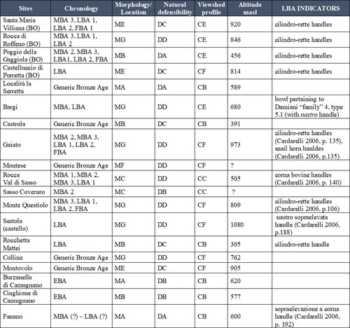
Fig.1 Classification according to Cardarelli 2006 of the investigated sites – focus on the viewshed profile: CA = Limited (if within 2 km from the site there are higher elevation preventing view beyond 180°), CB = proximal valley control (if within 3 km from the site there are higher elevation preventing view beyond 180°, visual dominance on the valley does not exceed 2 km), CC = widespread valley control (if within 3 km from the site there are higher elevation preventing view beyond 180°, wide visual dominance on the valley which exceeds 3 km), CD = broad (if within 3 km from the site the view angle reaches 180°), CE = extensive (if within 3 km from the site the view angle goes beyond 180°), CF = very extensive (if within 6 km from the site it the view angle exceeds 270°)
MACRO – The first step taken was to vectorize the legacy data sites (both those cited in the Atlante and those in Guerra's PhD) into GIS environment. When looking at those associated to the LBA[16], a peculiarly high concentration of sites seemed to coevally exist on both valleys, possibly creating connecting patterns between the two “realities”. Out of 19 sites censed, 11 appeared to have signs pointing at an occupation around the 13th century BCE. It is important to specify that the “general” indicator for LBA here used is the presence of the well-known cilindro-rette handles within the retrieved ceramics. Aside of that, other markers for the chronological attribution are used, and for those please refer to the rightmost column of Fig. 1.
This density had already been noticed separately in both works[17], but it was now interesting to connect the two areas looking at hints to try to deepen the potential links and interconnections. Another relevant point was that the different coeval sites appeared to be located at different altitudes, in morphologically different locations, prompting the possibility that they may had played different roles in the wider landscape of the Apennines.
To enhance the analysis, we reorganized the Bolognese sites into the scheme proposed by Cardarelli (see fig. 1). This was obtained by blending GIS viewshed analysis with field survey. At this stage the viewshed analysis was performed using a single observer point for each site, on a blended hillshade raster file generated upon 5 meters ground resolution DTM tiles retrieved on the Geoportale website of Emilia Romagna region. To ascertain the other two parameters, defensibility and morphology location, field surveys were performed for 16 out of the 19 sites identified in the researched area. The perused areas were those mentioned in the bibliography, and for those sites with uncertain coordinates, identification was improved by looking at specifical morphological criterions, such as hillocks, or in some case locating potentially prehistoric akin pottery shards within runoffs.
SEMI MICRO – At this level it was subsequently possible to identify a couple of site clusters which appeared to be located in two distinctive parts of their landscape within a 4,5 to 6 km range between them; one located within the valley floor and the other on the ridge. Again, both viewshed analysis and field survey proved intervisibility between them (see fig.2). The fact that those “twin sites” were coeval prompted the question on what kind of relationship there could have been between them. Analyzing at this stage historical viability it was clear to see that those located closer to the river could have easily represented managing sites, directly interacting with the transiting people on their route heading toward the Po plain or vice versa. Displaying limited visual control on the valley, those sites could have needed parallelly existing sites to perform the visual control for them. That is when the better positioned sites, located on strategically higher ground, on the ridges, would have played their part. This duality can be defined as management, for the valley floor sites, and control for those on the ridge above. The identified “twin sites” are in those case those of Poggio della Gaggiola on the Reno River, with its paired site of Castelluccio di Porretta, and the valley site of Rocchetta Mattei, still on the Reno and Monte della Croce perched on the overlooking crest.
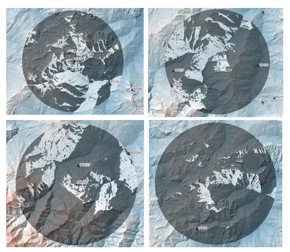
Fig. 2 - Simplified viewshed analysis examples performed on the listed sites to determine their long distance "viewshed profile"; clockwise from top left: i) Monte della Croce [BO091], ii) Poggio della Gaggiola [BO004], iii) Castelluccio di Porretta [BO090], iv) Rocca di Roffeno [BO099]. The analyzed radius is of 6 km. with binary characterization, also to determine the possible intercommunicability with proximal/non-proximal sites.
MICRO – Closing down on the site of Monte della Croce, the idea was to try improving the knowledge not just of the aforementioned relationship with its kin site located on the valley floor, but also to attempt a preliminary definition of the internal morphology of this longstanding hilltop sites, which remains at present very difficult to ascertain due to the limited number of scientific dig campaigns for this part of the Apennines. Here too both GIS analysis and field reckon were performed various times and during different periods of the year. First, cumulative viewshed analysis proved once more both the intervisibility between this site and eight coeval sites located within a range of 15 km, including the twin site of Rocchetta Mattei (see fig. 3).
During every field survey drone photography was performed, both to obtain orthophotos for lab study in order to identify potential visible markers of morphological anthropized transformation if visible, and at the same time elaborating raw quality 3D models. The fortuitous cleansing operation of the undergrowth on the summit of the station, was the lucky event that unlocked some new hints at the internal organization of these sites.
Located respectively at 5 and 10 meters from the top plateau, northwest of the previously excavated area, with a simple dispelling of the first layer of humus, it was still possible to identify traces of what resembled terraced earthworks (see fig. 4). The abundant quantity of sherds within the premises of these “structures”, apparently partially circuiting the upper plateau for at least 15 meters, seemed to point out at a way more complex organization and ideally role, played by this site. The apparent unicity of these attestations for this part of the territory could potentially be a mere illusion, given the multiple coevally existing evidence of similar structures in the neighboring Rocca di Roffeno[18], Groppo Predellara di Varsi[19] near Parma, the castellari of Liguria[20] and the slightly older terraced structures identified at Colombare di Negrar[21] in Veneto region. It is possible to cautiously infer that this “rareness” is simply ascribable to the lack of deeper research in this sector of the Apennines above Bologna, a gap that this project proposes to fill by kickstarting a new season of research.
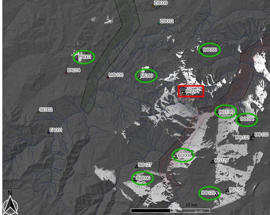
Fig. 3 - Cumulative viewshed analysis using seven different cluster areas within the site of Monte della Croce, corresponding to equally hypothetical locations for the dwelling based on the pottery shard finding and the earthworks identified. The considered maximum distance is 15 km. and circled in green are the sites within range for visual communication.
Preliminary results
Although at a very embryonic stage, this short presentation aims at reviving the interest into this part of the Apennines, a key area which deserves more studies and that even by scratching its surface appears to have a lot more to tell for what concerns the central phases of the Bronze Age. From a methodological point of view, it shows how combining well directed GIS analysis, even at a very basic level, it is possible to drive more efficiently the field work. The hope is that with the upcoming excavation of Monte della Croce new resources will come available to expand the methodological and instrumental inventory, including Lidar drone data to further understand the potential morphological pattern of these upland sites[22].
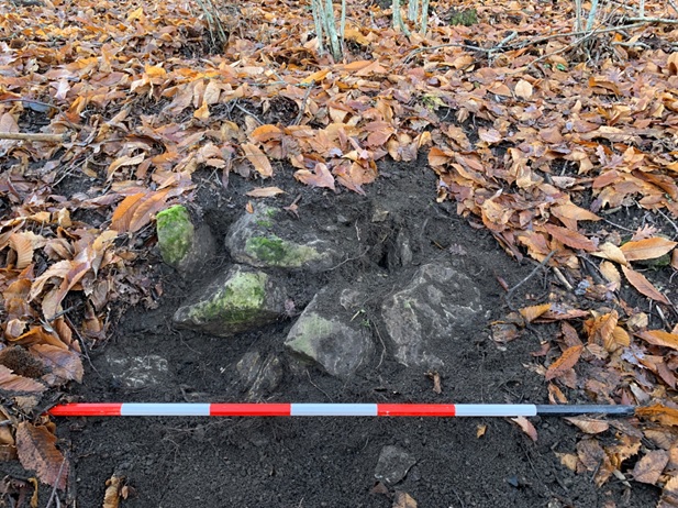
Fig. 4 “Terraced” earthworks identified as potential terraced platforms on Monte della Croce
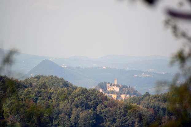
Fig. 5 Intervisibility between Monte della Croce and numerous sites on the Modenese side – in the foreground Montese (LBA?), secondarily behind Gaiato (MBA 3 onward) and on the background Monte S. Andrea (LBA 2) and Monte Santa Giulia
Notes
[1] Cardarelli 2006, p. 48, [2] Fraser 1983, pp. 298-303, [3] Clarke 1977, p.11-15, [4] Cardarelli 2006, p. 62, [5] Guerra 2015, p.11, [6] Putzolu, Cavazzuti 2019, p. 259, [7] Cattani, Monti 1997, p. 289; Ghiretti 2003, pp. 111 e ss.; Cardarelli 2006, pp. 59 e ss., [8] Cavazzuti, Putzolu 2015, p. 57-63, [9] Cavazzuti, Putzolu 2015, p. 60, [10] L. Morabito, G. Pizziolo, L. Sarti 2018, p. 211, [11] Cardarelli 2006, p. 62; Christaller 1933, [12] Brizio E. 1887, pp. 387-391., [13] Mansuelli G.A. 1951-52a, p.157; Mansuelli G.A. 1951-52b, p. 162; Arias P.E 1951, p. 195; Scarani R. 1957, pp. 417- 462; Scarani R. 1959, pp. 9-26; Scarani R. 1963, p. 391-392, 412; Kruta Poppi L. 1975, pp.137- 148., [14] For the chronology, please refer to Bernabò Brea M., Cardarelli A. 1997, pp. 295-378; Cardarelli A. 2006, pp. 78-87, [15] Foschi P. 2012, [16] see fig 1. rightmost column for the parameters for the attributions to LBA, [17] Cardarelli 2006, p. 44; Guerra 2015, p. 190, [18] Kruta Poppi L. 1974, p. 443, [19] Giretti A. 2000, p. 138, [20] Delfino, Del Lucchese (2020), pp.143-144, [21] Recent news released by La Statale News (Università degli Studi di Milano) on February 14 2023; field director: Prof. Umberto Tecchiati. Link: https://lastatalenews.unimi.it/sito-colombare-negrar-valpolicella-rivela-terrazzamenti-delleta-bronzo , [22] As an example of the potential of these Lidar based wide range analysis, please see Fontana G. 2022, pp. 245-261
Bibliography
Arias P.E. 1951, Scoperte e Scavi paletnologici in Italia. Notiziario1951. Emilia, S. Maria di Villiana, in RSP, VI, 1951, p. 195.
Bernabò Brea M.A, Cardarelli A., Cremaschi M., 1997 - L’insediamento collinare e montano, in Bernabò Brea M.A, Cardarelli A., Cremaschi M. (eds.), Le terremare. La più antica civiltà padana, Modena
Brizio E. 1887, Regione VIII (Cispadana). Porretta, Di una terramara scoperta al Poggio della Gaggiola, e di altra a S. Maria di Villiana nel comune di Porretta. Rapporto del ff.R.Commissario prof. E. Brizio, in NSc 1887, pp. 387-391.
Cardarelli A. 2006, L’Appennino modenese nell’età del Bronzo, in A. Cardarelli, L. Malnati (eds.), Atlante dei beni archeologici della provincia di Modena, II, 2, Firenze, All’Insegna del Giglio
Cattani, Monti 1997, L’insediamento dell’età del Bronzo nelle valli dei torrenti Dopo e Dragone (Appennino modenese), in Le Terramare 1997, pp. 289-291.
Cavazzuti C., Putzolu C. 2015, Strategie di occupazione dell’appennino emiliano durante l’età del bronzo, in Cambi F., De Venuto G., Goffredo R. (eds.), I pascoli, i campi, il mare. Paesaggi d’altura e di pianura in Italia dall’Età del Bronzo al Medioevo, Storia e archeologia globale, 2, Bari: 51-71.
Clarke, D. (1977). Spatial information in archaeology. In D. Clarke (Ed.), Spatial archaeology, New York: Academic Press. Colt Hoare, R. (1812)
Delfino D., Del Lucchese A. 2020a, L'età del Bronzo in Liguria: percorsi tecnologici e culturali in Danckers J., Cavazzuti C, Cattani M., “Facies e culture nell'età del Bronzo italiana?” at Academia Belgica, Roma
Delfino D., Del Lucchese A. 2020b, Terraced-walled settlements in Bronze Age Liguria (north-western Italy): can we speak of Iron Age ‘castellari’? in Late Prehistoric Fortifications in Europe: Defensive, Symbolic and Territorial Aspects from the Chalcolithic to the Iron Age, Proceedings of the International Colloquium ‘Fort Metal Ages’, Guimarães, Portugal
Fontana G. 2022, Italy’s Hidden Hillforts: A Large-Scale Lidar-Based Mapping of Samnium, Journal of Field Archaeology, 47:4, 245-261, DOI: 10.1080/00934690.2022.2031465
Foschi P. 2012, Castelli e fortificazioni nel bolognese: repertorio e cronologia, Porretta Terme, Gruppo di Studi Alta Valle del Reno
Fraser D. 1983, Land and Society in Neolithic Orkney, Oxford 1983.
Ghiretti 2000, L’età del Bronzo nelle Valli di Taro e Ceno (Appennino Parmense),in Padusa, XXXVI
Ghiretti 2003, Preistoria in Appennino. Le valli parmensi di Taro e Ceno, Parma 2003.
Guerra L. 2015, Strategie insediative, economiche e scambi culturali nell'Appennino bolognese e romagnolo nell'eta' del Bronzo, [Dissertation thesis], Alma Mater Studiorum Università di Bologna. Dottorato di ricerca in Archeologia e storia dell'arte, 26 Ciclo. DOI 10.6092/unibo/amsdottorato/7216.
Kruta Poppi L. 1974, Un abitato preistorico nell'Appennino Bolognese. Relazione preliminare, RSP XXIX, pp. 437-461.
Kruta Poppi L. 1975, Annotazioni sulla fisionomia culturale dell'Appennino Bolognese nel Tardo Bronzo , Padusa XI, 1-4, pp.137-148.
Mansuelli G.A. 1951-52a, Scoperte e scavi paletnologici in Emilia. Notiziaro 1951, Provincia di Bologna, Santa Maria di Villiana, in EP 3, p. 157.
Mansuelli G.A. 1951-52b, Scoperte e scavi paletnologici in Emilia. Notiziaro 1952, Provincia di Bologna, Santa Maria di Villiana, in EP 3, p. 162.
Morabito L., Pizziolo G., Sarti L. 2018, Rapporti culturali e vie di comunicazione tra Toscana Settentrionale ed Emilia-Romagna durante l’Età del Bronzo: un approccio territoriale. in M. Bernabò Brea (ed.) 2018, Preistoria e Protostoria delll’Emilia Romagna - II, Studi di Preistoria e Protostoria, 3, II, Firenze, pp. 209-218
Putzolu C., Cavazzuti C. 2019, L’appennino emiliano nell’età del Bronzo: la frontiera meridionale delle terramare in: M. Bernabò Brea, M. Maffi, P. Mazzieri (eds.), Le quistioni nostre paletnologiche più importanti… Trent’anni di tutela e ricerca preistorica in Emilia occidentale, pp. 251-264, 2019
Scarani R. 1957, Saggio di una carta pre-protostorica dell’Emilia, in SE XXV, 1957, pp. 417-462.
Scarani R. 1959, Castel di Casio e Gaggio Montano (Bologna). Stazioni dell’età del Bronzo, in NSc 1959, serie VIII, vol. 8, p. 9-26.
Scarani R. 1963, Repertorio di scavi e scoperte dell’Emilia e Romagna. in Preistoria dell’Emila
Highlights
-
Looking for new clues on the first stable Bronze Age settling in the central Emilian Apennines, starting from the “perfect” template site