- Home
- Project Apri sottomenù
- UPLAND ARCHAEOLOGY WORKSHOP Apri sottomenù
-
Abstracts
Apri sottomenù
- Wieke de Neef (Ghent University / Otto-Friedrich University Bamberg)
- Francesco Carrer (School of History, Classics and Archaeology, Newcastle University (UK))
- Umberto Tecchiati (University of Milan)
- Tesse Stek (KNIR - Royal Netherlands Institute in Rome)
- Riccardo Rao (University of Bergamo)
- Fabio Saggioro, Nicola Mancassola (University of Verona)
- Roberto Maggi, LASA (Laboratorio di Archeologia e Storia Ambientale), University of Genova
- Andrea Cardarelli, Andrea Conte (University of Rome "La Sapienza")
- Federico Zoni (University of Bergamo)
-
Short presentations
Apri sottomenù
- SHORT PRESENTATIONS PROGRAMME
- Putzolu et al., The 2nd Millennium BC in the northern Apennines
- Giorgi et al., New insights into the upland landscape of ancient Epirus, Southern Albania
- Carra, Subsistence economy in the Bronze Age in the northern Apennines upland
- Gaucci et al., Mapping mobility in the Apennines: The Reno Valley between the 6th-4th century BCE and the contemporary period
- Cirelli et al., Insediamenti di altura nell’Appennino Romagnolo e Toscano nel medioevo
- Betori et al., Amatrice: da castello a città
- Del Fattore, Upland landscapes and settlements strategies in the Central-Southern Apennines (1000 BC-2023 AD)
- Conversi et al., The site of Albareto cà Nova
- Bottazzi et al., Attorno al Monte Titano (739 m s.l.m.). Ricerche archeologiche e paleoambientali in Repubblica di San Marino
- Conversi et al., Il sito tardoatico – medievale d’altura della Piana di S. Martino , Pianello Val Tidone (PC)
- Cortesi et al., Archeologia dei paesaggi in una vallata appenninica: il progetto “Val Fantella” (Premilcuore, FC)
- Barbariol, Farms abandonment in Iceland
- Garattoni, Doss Penede (Nago, TN): progettare e costruire un insediamento minore nell’Alto Garda in epoca romana
- Santandrea, Detecting and Mapping Hilltop Sites between the Cesano, Misa, and Nevola River-Valleys
- Bonazzi et al., “Media Valle del Cedrino”: a region between uplands and plateaus
- Zanotti, Back to Monte della Croce
- Monticone et al., Un approccio di archeologia museale al ri-studio del sito neolitico di Chiomonte-La Maddalena (Piemonte, Italia). Revisione ed aggiornamento dei dati dal 1988 al 2023.
- Facciani et al., Exploring the funerary landscape of the Samarkand piedmont area
- Kaur and Poddar, Colonial Churches of Shimla: Public Archaeology as a Tool for Engagement and Outreach
- Datta, Upland Buddhist Monastic Complexes and the Pala Kingdom: Reviewing the Highland-Lowland Relationships in Ancient Bengal
- Staff
- Contacts
- Events calendar
- Seminars Apri sottomenù
- NEWS Apri sottomenù
Gaucci et al., Mapping mobility in the Apennines: The Reno Valley between the 6th-4th century BCE and the contemporary period
Andrea Gaucci, Matteo Proto, Anna Serra
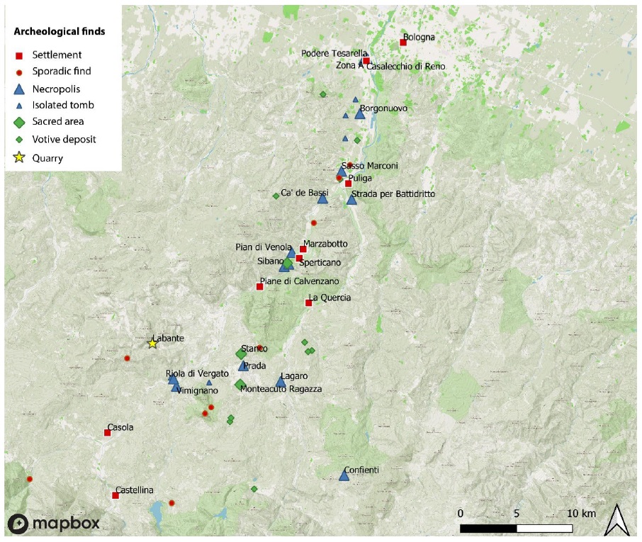
Fig. 1: Distribution of minor sites and settlements in the Reno, Setta, and Limentra valleys.
The contribution is part of the larger ongoing AlmaIdea project APPENNINICA directed at the comprehension of mobility between the 6th-4th century BCE in the Reno district on the Apennines. During the Etruscan period, this valley has been the privileged itinerary toward the Arno Valley, as suggested by the network of settlements and minor sites that proved the district's pivotal role among the Po Valley's trade routes1.
The first part of the project focuses on a systematic mapping of the findings and sites in this area, collecting all the information available in published records2 and the local cartography3. All the information has been collected in a database linked to a QGIS project to correctly visualize the disposition of findings through the valley. Discoveries made in the XIX century up till the first half of the XX century have been difficult to locate precisely due to the lack of topographic references with modern cartography: in these cases, an area of pertinence has been identified rather than the exact place. Moreover, the localization of sites has reviled a fragmentation of information: sometimes similar findings have been made in adjacent localities, a fact that could suggest larger sites or diffusion of archaeological materials on a wide surface. In these cases, different data could be merged as part of a singular site, reducing the dissemination of minor sites on the territory.
Then, the data will be classified through various parameters both quantitative (amount and typology of archaeological finds; extension of the area; modality of investigation e.g. through excavation or sporadic findings) and qualitative (reliability of the data; seasonality or permanence; geographical location e.g. ridge sites, hillside or valley sites; river proximity; visibility among sites), parameters used generally as markers in similar projects directed to uphill mobility. This contribution aims to offer an overview of the data collected up to now and to discuss the identified parameters.
The analyses of the distribution and categorization of sites may allow us the investigation mobility through the strategic disposition of settlements in the valley4, necessary for the development of the second part of the project, which will be focused on a comparison between pre-Roman and contemporary mobility. During the XIX and XX centuries, the Reno and Setta district has been pivotal in the development of the infrastructural network between Bologna and Firenze with the construction of the railway and recently the highway. The research will also highlight how the recent mobility has affected the archaeological finds (e.g. the SS Porrettana run through the site of Marzabotto). Moreover, recently slow tourism has led to the increased popularity of the valley thanks to trekking itineraries that allow the crossing of Apennines (such as the so-called “Via degli dei” that connects Bologna and Firenze with a four-day trip).
The historical parallel will be necessary to analyze the different strategies of the Appennine district’s exploitation through time. From a practical point of view, the final stages of the research will be aimed at the enhancement of slow tourism thanks to the development of itineraries collected on an online friendly-user platform that will merge the geohistorical perspective.
_____________________________________________________
1 On the topic: Sassatelli 1990 ; Sassatelli – Bertani 1992.
2 Starting from catalogs of findings (such as Scarani 1963) up to analysis of population and settlement distribution (Tovoli 1972 ; Malnati 1988 ; De Marchi 1999 ; Trocchi 1999) and recent discoveries (e.g. the settlement of La Quercia in Desantis 2016).
3 The PSC of the Municipality of Marzabotto and Vergato collects all the information on their territories.
4 On this topic: De Maria 1992 ; Mansuelli 1992 ; Millemaci 1999.
BIBLIOGRAPHY
De Marchi 1999 = L. De Marchi, Una ricerca di archeologia globale del territorio nel settore emiliano della Val Reno (Appennino settentrionale, prov. BO), in Archeologia dell’Emilia-Romagna, 3, 1999, p. 255-259.
De Maria 1992 = S. De Maria, Appunti sul popolamento antico e la viabilità nella valle del Reno, La viabilità tra Bologna e Firenze nel tempo. Problemi generali e nuove acquisizioni (Atti del Convegno, Firenzuola - S. Benedetto Val di Sambro, 1989), 1992, p. 217-230.
Desantis 2016 = P. Desantis, Gli etruschi fra Reno e Setta: il nuovo insediamento De La Quercia (Marzabotto-Bologna), Annali della Fondazione per il Museo «Claudio Faina», Roma, 2016 (23), p. 377-397.
Malnati 1988 = L. Malnati, L’affermazione etrusca nel modenese e l’organizzazione del territorio, Modena dalle origini all’anno mille. Studi di archeologia e storia (Catalogo della mostra, Modena 1989), 1988, p. 137-152.
Mansuelli 1992 = G.A. Mansuelli, Aspetti storici della viabilità transappenninica in età antica, La viabilità tra Bologna e Firenze nel tempo. Problemi generali e nuove acquisizioni (Atti del Convegno, Firenzuola - S. Benedetto Val di Sambro, 1989), Bologna, 1992, p. 33-40.
Millemaci 1999 = G. Millemaci, Viabilità transappenninica etrusca (VI - V sec. a.C), in Rivista di topografia antica, 9, 1999, p. 121-140.
Sassatelli 1990 = G. Sassatelli, La situazione in Etruria padana, in G. Colonna (a cura di), Crise et transformation des sociétés archaïques de l’Italie antique au Ve siècle av. J.C. (Actes de la table ronde, Rome 1987), Roma, 1990, p. 51-100.
Sassatelli – Bertani 1992 = G. Sassatelli, M.G. Bertani, Il territorio del Reno in età preromana e romana, Il fiume Reno e il suo territorio, Bologna, 1992.
Scarani 1963 = R. Scarani, Repertorio di scavi e scoperte dell’Emilia e Romagna, Preistoria dell’Emilia e Romagna. Nuovi contributi., Bologna, 1963 (Documenti e studi, VIII), p. 175-634.
Tovoli 1972 = S. Tovoli, Il confluente di Casalecchio. Profilo demografico di un settore del comprensorio bolognese in età preromana, in Studi etruschi, 40, 1972, p. 341-356.
Trocchi 1999 = T. Trocchi, La Valle del Setta nell’età del Ferro, in Ocnus, 7, 1999, p. 127-138.