- Home
- Project Apri sottomenù
- UPLAND ARCHAEOLOGY WORKSHOP Apri sottomenù
-
Abstracts
Apri sottomenù
- Wieke de Neef (Ghent University / Otto-Friedrich University Bamberg)
- Francesco Carrer (School of History, Classics and Archaeology, Newcastle University (UK))
- Umberto Tecchiati (University of Milan)
- Tesse Stek (KNIR - Royal Netherlands Institute in Rome)
- Riccardo Rao (University of Bergamo)
- Fabio Saggioro, Nicola Mancassola (University of Verona)
- Roberto Maggi, LASA (Laboratorio di Archeologia e Storia Ambientale), University of Genova
- Andrea Cardarelli, Andrea Conte (University of Rome "La Sapienza")
- Federico Zoni (University of Bergamo)
-
Short presentations
Apri sottomenù
- SHORT PRESENTATIONS PROGRAMME
- Putzolu et al., The 2nd Millennium BC in the northern Apennines
- Giorgi et al., New insights into the upland landscape of ancient Epirus, Southern Albania
- Carra, Subsistence economy in the Bronze Age in the northern Apennines upland
- Gaucci et al., Mapping mobility in the Apennines: The Reno Valley between the 6th-4th century BCE and the contemporary period
- Cirelli et al., Insediamenti di altura nell’Appennino Romagnolo e Toscano nel medioevo
- Betori et al., Amatrice: da castello a città
- Del Fattore, Upland landscapes and settlements strategies in the Central-Southern Apennines (1000 BC-2023 AD)
- Conversi et al., The site of Albareto cà Nova
- Bottazzi et al., Attorno al Monte Titano (739 m s.l.m.). Ricerche archeologiche e paleoambientali in Repubblica di San Marino
- Conversi et al., Il sito tardoatico – medievale d’altura della Piana di S. Martino , Pianello Val Tidone (PC)
- Cortesi et al., Archeologia dei paesaggi in una vallata appenninica: il progetto “Val Fantella” (Premilcuore, FC)
- Barbariol, Farms abandonment in Iceland
- Garattoni, Doss Penede (Nago, TN): progettare e costruire un insediamento minore nell’Alto Garda in epoca romana
- Santandrea, Detecting and Mapping Hilltop Sites between the Cesano, Misa, and Nevola River-Valleys
- Bonazzi et al., “Media Valle del Cedrino”: a region between uplands and plateaus
- Zanotti, Back to Monte della Croce
- Monticone et al., Un approccio di archeologia museale al ri-studio del sito neolitico di Chiomonte-La Maddalena (Piemonte, Italia). Revisione ed aggiornamento dei dati dal 1988 al 2023.
- Facciani et al., Exploring the funerary landscape of the Samarkand piedmont area
- Kaur and Poddar, Colonial Churches of Shimla: Public Archaeology as a Tool for Engagement and Outreach
- Datta, Upland Buddhist Monastic Complexes and the Pala Kingdom: Reviewing the Highland-Lowland Relationships in Ancient Bengal
- Staff
- Contacts
- Events calendar
- Seminars Apri sottomenù
- NEWS Apri sottomenù
Bonazzi et al., “Media Valle del Cedrino”: a region between uplands and plateaus
Bonazzi Lorenzo*, Riggio Smeralda**, Barchiesi Francesca**
*Alma Mater Studiorum – Università di Bologna
**Freelance archaeologist
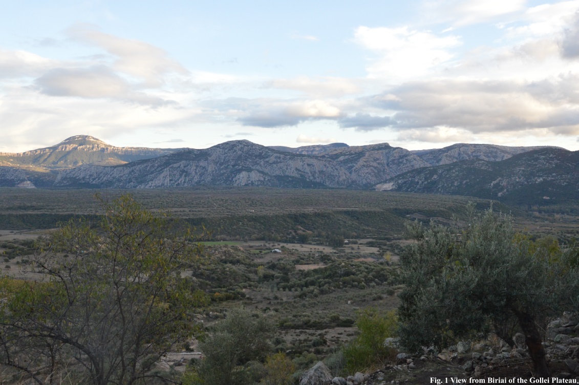
Fig.1 View from Biriai of the Gollei Plateau.
The “Media Valle del Cedrino” project, which began in 2017, involved the territories between the Gollei plateau and the Biriai hill in the municipal areas of Oliena and Dorgali (province of Nuoro, Sardinia). Survey and digital documentation (with camera and drone) were carried out over an area of more than 900 hectares. Regarding only the main archaeological evidences, 45 archaeological concentrations were recognized, documented and surveyed. The main contexts include: three necropolis of Domus de Janas[1], the megalithic wall and the structures of Suvegliu, the shelter of Frathale, two protonuraghi[2], seven tombs of the giants[3], nine nuraghi (including four “nuraghi complessi”[4]), four extensive protohistoric villages, seven roman structures/inhabitations, five churches, five traces of medieval settlements, seven modern structures (pre-20th century) of particular interest. All 45 sites have been documented with photos from the ground, lidar and drone surveys, creating (where visibility allowed) accurate 3D models. The collection of materials was systematic and every object or structure was positioned using gps points. The research continues with new systematic surveys and, above all, with the excavation of Suvegliu.
The dynamics of occupation and exploitation of the Gollei hills and plateau will be briefly analyzed diachronically, describing the characteristics of the main archaeological contexts. The emphasis will be placed both on the reoccupation of some areas and on the abandonment of others, also in relation to the routes.
The area investigated is located in the middle course of the Cedrino river between the mountains of the Supramonte di Oliena and the highway 129 immediately north of the Biriai hill. The area is characterised by the presence of the Cedrino river that separates the basaltic plateau from the Supramonte formation. To the north, between the plateau and Biriai, there is a hilly and sub-flat area (defined as the Oliena plain) with numerous isolated granite outcrops. The average height of the plateau is 200 m a.s.l. The areas on the fringes of the plateau are between 100 and 150 m a.s.l. Mount Su Cungiadu is the highest point of the Gollei plateau and it was the eruptive vent from which the lava flowed. It is 231 m high and is surrounded by a fertile circular volcanic depression with a diameter of about 820 m and an average height of 180 m. The isolated highlands, including those on which the nuraghi San Nicola and Su Casteddu stand, are located between 160 to 200 m a.s.l., while Punta Biriai is 360 m a.s.l.. The ridges of the Supramonte, on the hydrographic right of the Cedrino, are the southernmost area investigated: their altitude ranges from 600 to 350 m a.s.l., and therefore they block the view from the north towards the Lanaitto valley and the interior of the Supramonte.
[1] Hypogeal tombs that spread in Sardinia starting from 4th millenium BCE.
[2] Antecedents of single-tower nuraghi.
[3] Collective graves from the Bronze age.
[4] Nuraghi with a more complex plan compared to single-tower nuraghi.
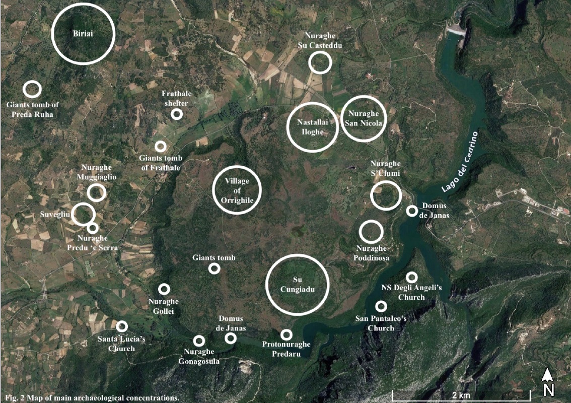
Fig.2 Map of main archaeological concentrations.
Janas de Domus
The three concentrations of Domus de Janas identified in the area are all excavated on the Gollei plateau. The first one is located near the modern bridge that crosses the Cedrino river, while the second one in front of the Lanaitto valley. The third group is the most consistent and includes four tombs, located on Monte Su Cungiadu. All these locations were chosen for their particularly elevated positions.
Biriai
The important Chalcolithic context of Biriai has been known since the discover of the settlement (Monte Claro culture) by Fulvia Lo Schiavo in 1979. During the survey, fifteen Monte Claro structures, partly excavated, fourteen menhirs and so-callad “sanctuary” were identified and documented. While the Chalcolithic structures are located on the saddle in the middle of the hill, other significant Bronze Age evidences were documented in the northern part: a single-tower nuraghe situated 80 m SE of Punta Biriai; a protonuraghe below, behind which a large village developed. From the village, non only Bronze ad Iron Age but also Roman materials have been found. The persistence of settlement in Biriai is meaningful and can be explained considering the ideal elevated location that allows a privileged view of the surrounding territories.
Riparo Frathale
The Frathale shelter has been studied by Alberto Moravetti and is located in the plain of the Frathale stream between Biriai and the Gollei plateau. It it is a granite boulder placed on one of the aforementioned isolated heights, below which there are geometric engravings that, according to previous interpretations, represent the plan of a village. Materials related to the Bell Beaker culture were found in this area.
Suvegliu
An official report by Ercole Contu dated 2 February 1971 describes the area of Suvegliu, located in the plain of Oliena (on the hydrographical left of the Rio Frathale, but it has never been the subject of detailed archaeological investigations. During the survey conducted by the University of Bologna between 2017 and 2019[1], a megalithic wall with an architraved entrance was identified, built around an isolated granite hill surrounded by dense vegetation. The face, where visible, is more than 4 m high and the entrance, which has been cleared this year during the first excavation campaign, has an opening more than 3 m in height.
In the first report given to the Superintendence by Ercole Contu, the perimeter wall is reported approximately 150 m long. However, although the full clean-up has not yet been completed, this evaluation seems to be downward.
In the central, higher part of the hill, there is a structure leaning against the natural rock on two levels and bordered by rectilinear walls; some walls lean against the natural rock at the top to form a smaller structure. Preliminary data and finds collected from the surface show a long-standing occupation with also Roman evidences.
Tombe dei giganti
Of the seven Giants Tombs identified, four are located at the four extremes of the plateau not far from other Bronze Age evidences. The other three are in the Rio Frathale plain, near nuraghe San Nicola, and the last one is 1 km SE of Biriai. According to a pattern commonly found in Sardinia, the Giants’ Tombs seem to mark the territory not too far from the probable settlements of reference.
Nuraghi
Starting with the protonuraghi (the earliest) in addition to the protonuraghe of Biriai, there is the protonuraghe Predaru on the southern edge of the Gollei plateau overlooking the Cedrino river. There is only one single-tower nuraghe on the plateau, Nuraghe Poddinosa, located 500 m SW of the imposing nuraghe complesso S’Ulumi on the eastern portion of the Gollei. The other nuraghi complessi are Nuraghe Gonagosula and Nuraghe Gollei, located slightly more than 1 km apart and both built on the SW edge of the plateau facing the course of the Cedrino river. Outside the plateau, nuraghi are located on isolated reliefs on whose slopes there are fertile areas. Single-tower nuraghi Predu ‘e Serra and Regre e Mele/Muggiaglio are built on granite heights similarly to the Arennegula/Frathale nuraghe, while single-tower nuraghi San Nicola and Su Casteddu are built on broader heights characterized by important clay outcrops.
All the nuraghi on the Gollei plateau are built facing the course of the Cedrino river; this choice could be due to the desire to be visible and at the same time have a view of the fertile areas and the course of the river and valley. The absence of nuraghi on the northern side of the plateau could be due to a lesser desire for visibility to and from those areas, considering the presence of other nuraghi on the northern heights.
Protohistoric villages
In addition to the village of Punta Biriai, there are three other villages referable to the Late Bronze Age and Iron Age, two of which are in an excellent state of preservation and cover more than 2 hectares, with very thick collapses in situ and complex structures. The large village of Orrìghile is in the SW about 700 m from the edge of the plateau, near an access point to the plain to the north. The village called Sas de Mattu (another toponym of Su Cungiadu) is located between the fertile volcanic depression of Su Cungiadu and the edge of the plateau towards the Cedrino river. The third village, located south of Nastallai area, is almost totally destroyed. The villages are not directly on the edge of the plateau and they are therefore not visible from the surrounding low-lying areas, as opposed to nuraghi.
Roman and medieval evidences
As far as the Roman period is concerned, there are considerable evidences of wide dispersions of materials and structures. Two of the main examples are concentrated near Nuraghe San Nicola and Nuraghe Su Casteddu, in particular near the first one. Another area where Roman and Late Antique structures and materials are reported is the edge of the volcanic depression of Su Cungiadu, specifically two areas located 500 m NW and 800 m NE of the protohistoric village of Sas de Mattu. Finally, the fourth main area is Nastallai/Iloghe, where there are also protohistoric traces, expecially near the church of San Pietro di Iloghe.
Medieval settling is again documented in the area of Su Cungiadu and in the area of Iloghe (toponym of a disappeared village), mainly near the ruins of the church of San Pietro di Iloghe. Continuity with the Roman period, but less consistent than in previous cases, was also found near the church of Santa Lucia, SW of the plateau. For the other country churches in the area, it is currently not possible to confirm a dating prior to the Modern Age.
Conclusions
During the Bronze Age there was a widespread settlement with a concentration of monumental evidences in elevated places near the traffic routes, the valley of the Cedrino river and the Oliena plain. In the late Bronze Age and Iron Age it is confirmed what has been observed in other areas of Sardinia: a centralisation of the settlement in larger nuclei, although earlier structures were still frequented, especially the nuraghi. The exploitation of areas already settled during the Bronze Age continued consistently during the Roman and Late Antique periods. Persistence and reoccupation can be attributed to the widespread presence of protohistoric traces at control points on the routes and in the most fertile and resource-rich places (where to find stone, water and clay, for example.
[1] Progetto survey “Media Valle del Cedrino”.
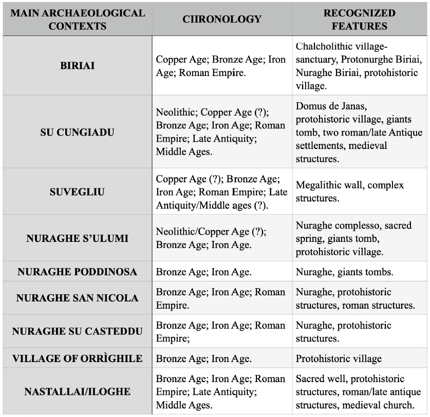
Fig.3 Summary table of main archaeological concentrations.
Highlights
-
Bonazzi Lorenzo*, Riggio Smeralda**, Barchiesi Francesca**