- Home
- Project Apri sottomenù
- UPLAND ARCHAEOLOGY WORKSHOP Apri sottomenù
-
Abstracts
Apri sottomenù
- Wieke de Neef (Ghent University / Otto-Friedrich University Bamberg)
- Francesco Carrer (School of History, Classics and Archaeology, Newcastle University (UK))
- Umberto Tecchiati (University of Milan)
- Tesse Stek (KNIR - Royal Netherlands Institute in Rome)
- Riccardo Rao (University of Bergamo)
- Fabio Saggioro, Nicola Mancassola (University of Verona)
- Roberto Maggi, LASA (Laboratorio di Archeologia e Storia Ambientale), University of Genova
- Andrea Cardarelli, Andrea Conte (University of Rome "La Sapienza")
- Federico Zoni (University of Bergamo)
-
Short presentations
Apri sottomenù
- SHORT PRESENTATIONS PROGRAMME
- Putzolu et al., The 2nd Millennium BC in the northern Apennines
- Giorgi et al., New insights into the upland landscape of ancient Epirus, Southern Albania
- Carra, Subsistence economy in the Bronze Age in the northern Apennines upland
- Gaucci et al., Mapping mobility in the Apennines: The Reno Valley between the 6th-4th century BCE and the contemporary period
- Cirelli et al., Insediamenti di altura nell’Appennino Romagnolo e Toscano nel medioevo
- Betori et al., Amatrice: da castello a città
- Del Fattore, Upland landscapes and settlements strategies in the Central-Southern Apennines (1000 BC-2023 AD)
- Conversi et al., The site of Albareto cà Nova
- Bottazzi et al., Attorno al Monte Titano (739 m s.l.m.). Ricerche archeologiche e paleoambientali in Repubblica di San Marino
- Conversi et al., Il sito tardoatico – medievale d’altura della Piana di S. Martino , Pianello Val Tidone (PC)
- Cortesi et al., Archeologia dei paesaggi in una vallata appenninica: il progetto “Val Fantella” (Premilcuore, FC)
- Barbariol, Farms abandonment in Iceland
- Garattoni, Doss Penede (Nago, TN): progettare e costruire un insediamento minore nell’Alto Garda in epoca romana
- Santandrea, Detecting and Mapping Hilltop Sites between the Cesano, Misa, and Nevola River-Valleys
- Bonazzi et al., “Media Valle del Cedrino”: a region between uplands and plateaus
- Zanotti, Back to Monte della Croce
- Monticone et al., Un approccio di archeologia museale al ri-studio del sito neolitico di Chiomonte-La Maddalena (Piemonte, Italia). Revisione ed aggiornamento dei dati dal 1988 al 2023.
- Facciani et al., Exploring the funerary landscape of the Samarkand piedmont area
- Kaur and Poddar, Colonial Churches of Shimla: Public Archaeology as a Tool for Engagement and Outreach
- Datta, Upland Buddhist Monastic Complexes and the Pala Kingdom: Reviewing the Highland-Lowland Relationships in Ancient Bengal
- Staff
- Contacts
- Events calendar
- Seminars Apri sottomenù
- NEWS Apri sottomenù
Barbariol, Farms abandonment in Iceland
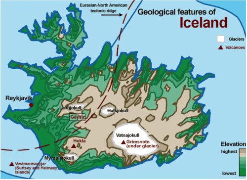
Fig. 1 Map of Iceland highlighting its geological features (https://www.exploratorium.edu/)
Introduction
The medieval abandonment of upland farms represents one of the most investigated
phenomena in Middle-Age Iceland (centuries 9th-12th). This paper aims to explore the causes of
such a process by taking into consideration both historical sources and material evidence from
different places in Iceland. It primarily seeks to better frame the impact of natural hazards such as
avalanches and landslides and suggests some potential new approaches to the investigation of
resilience and vulnerability of upland farms in medieval Iceland.
HISTORY
The Norse colonisation of Iceland (Landnám) was a rapid process. Archaeological
evidence demonstrates that the first human settlement on the island began around A.D. 874,
allegedly when the Norwegian hero Ingólfr Arnarson founded the town of Reykjavík.
The first wave of Norse settlers selectively occupied sheltered areas near Iceland’s coast
and in major fluvial basins in order to gain access to grazing areas in coastal lowlands and to
exploit significant marine and freshwater resources and. Only later they started to move into the
highlands regions (Roy et al., 2018).
GEOGRAPHY
Iceland is geologically and geomorphologically active island whose landscape is the result
of glacial, volcanic, and tectonic processes; moreover wind, fluvial, and slope processes combine to produce
very dynamic landscapes (Lebrun et al., 2023). The island owes its existence and geological processes
to a large volcanic fissure along the Mid-Atlantic Ridge, where t h e Eurasian and
American tectonic plates meet. Moreover, its position in the North Atlantic region explains an
important role in the environmental changes that the landscape underwent during the Holocene,
because of frequent anomalies and variations (Fig.1).
Mountains and highlands in Iceland make up about half of the land area of the country.
Glaciers and volcanoes are also considered part of Iceland highlands, thus making most of the
island “uninhabitable”. However, archaeological finds shows that, at least during the beginning of
the settlement of Iceland, farms were built in these areas too.
In particular, slope processes are strongly connected with climate changes and extreme
meteorological events. In Iceland these extreme meteorological events come in the shape of rapid
snowmelt, heavy snow accumulation and storms and have been identified as triggering factors for
debris flows and snow avalanches (Lebrun et al., 2023). The subsequent colluvial deposits can be
considered as proxy for extreme meteorological events. The same cataclysms have a major
impact on the landscape and can be a major threat to human settlements.
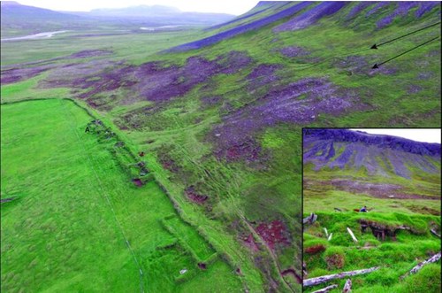
Fig. 2 Aerial picture of the western part of Mt. Flautafell. Farm ruins and snow avalanches landforms are visible. (Lebrun et al., 2023)
Materials and Methods
To explore why the phenomenon of farm abandonment was so widespread in Icelandic
highlands both historical texts, in particular sagas and annals and the environmental history of the
sites, were taken into account.
Considering the celebrated realism that surrounds Icelandic sagas, one would easily think
to find numerous references to the hazards to which Iceland is subjected. Some volcanic activities
are indeed recorded in the Landnámabók, the Book of Settlements written between the 9th and
the 10th century, but only rarely these events are put in relationship with human settlements. In
total, only four settlers’ stories show volcanic eruption (Falk, 2007). These rare pieces attest more
the interest of medieval Icelandic historians in discovering the origin behind place names, building
of farmsteads and topographic features (Falk, 2007). The other main narrative genre is that of the
sagas of the Icelanders. However, strangely the Íslendingasögur (family sagas) don’t mention
explicitly natural hazards. For example, only four episodes of avalanches or landslides were
recorded in these sources. Different scholars have noted how these sagas rarely describe natural
calamities; on the other hand, other types of disasters such as shipwrecks, are more commonly
reported (Falk, 2007; Barraclough 2012).
The slope process described in the Sturlunga saga, one of the family sagas, apparently
took the lives of five people. Since then, until the present day, approximately 680 casualties
derived from slope process events have been documented, for sure a huge number for such a
small population (Lebrun et al., 2023).
It is from the 13th century, when annals started to be kept to record important historical
events, that hazards are more regularly attested. Annals also mention events that happened
before the 13th century, even if it is not sure what source did the historians used for their
meteorological data. The most comprehensive annals are the Annales Regii and the Skálholts
Annals, which cover the period 1300 – 1356 ( the latter, unfortunately, do not cover the years
1013-1180). All the annals mention in fact different natural catastrophes, such as earthquakes,
landslides and volcanic eruptions (McCreesh, 2018).
Then a combined study of the sites and different soil was done. In this part of the study
tephrochronology played an important role to determine the date of abandonment of farms.
Tephrochronology is a dating method first applied by Sigurdur Thorarinsson, based on the
identification, correlation and dating of tephra layers. Because of the large number of severe
volcanic eruptions that took place in Iceland, past studies could establish a detailed chronology of
pre-occupational and post-occupational archaeological events in the island based on such
volcanic markers (Thorarinsson, 1981).
On the mount Þórsmörk, in southern Iceland, at least five farms have been discovered
(Vésteinsson, 1998; Dugmore et al., 2009). Only one of those, Husadalur, escaped erosion; the
other four were subjected to frost action, deflation and water erosion. These processes have
exposed different artefacts dated between the 9th and the 12th century, suggesting that the farms
were abandoned around the 12th century. The site was later reoccupied during the 19th century.
The combined study of the tephra and field layers successfully dated the environmental changes
that happened on the mountain ridge. These episodes of landscape instability probably happened
between the 10th and the 13th centuries, with localised episodes of soil erosion to the bedrock
that ended before AD 1300 (Dugmore et al., 2009).
Mount Flautafell, in north-east Iceland, has three main farms built on its slope (Lebrun J. et
al., 2023). In this site five tephra layers were identified, the more recent being the one caused by
the Veiðivötn eruption in 1477. Furthermore, one of these layers was disturbed by either cryogenic
or slope process, or by a combination of the two. Landforms typically associated with landslide
and snow avalanches are clearly visible on the mountain slope, making possible that slope
processes happened on at least two of the three considered farms (Lebrun et al., 2023) (Fig.2).
A peculiar event happened on the mount Langholt, in northern Iceland (Bolender Douglas,
et al., 2011). Here two farms, Stóra-Seyla and Glaumbær, were first built on the lowland at the foot
of the mountain, but were relocated on a higher location during the 11th century. The former was
then inhabited until the 20th century, while the latter was definitively abandoned around the 10th
century. Farm relocation was a pretty common practice when a farm was hit by a disaster; we can
find another example in the site of Myrkárdalur, a farm situated in the highland that was partially
destroyed by a landslide in the 14th century, and thus moved further west (Harrison, 2011). Both
farms show evidence of localised environmental change. In particular at Stóra-Seyla excavations
showed rapid soil accumulation after the deposition of the Hekla tephra - dating to CE 1104,
which could have been caused by soil erosion. However, no evidence of natural hazards had been
found at Glaumbær (Bolender Douglas, et al., 2011).
In the inland there’s little presence of human activity. An example can be the site of
Pálstóftum, that sadly lies within an area submerged after the completion of a hydroelectric dam
(Lucas et al.,2007; Lárusdóttir, 2019). However, the climate of internal Iceland is more hostile than
that of coastal areas and the majority of the land corresponds with volcanoes and glaciers.
Discussion
Multiple scholars have studied and confirmed the extreme human impact on soil,
vegetation and therefore landscape in the first period of the Norse settlement. It has been
estimated that about 90% of the forest and 40% of the soil present in the 9th century had
disappeared (McGovern et al., 2007). Of course, the highlands experienced instability too. Can we
say that these environmental changes were the cause of farm abandonment? In some cases
archaeological evidence suggests this it was the case. In other cases, evidence is less
straightforward: for example if we take into consideration the farms of mounts Þórsmörk and
Flautafell we can assume that either human impact and natural processes concurred to erosion
and landslides, or a combination of the two, after which the farms were abandoned (Dugmore et
al., 2009; Lebrun et al., 2023).
The examples of the Langholt region are, however, different. A possible explanation that
was given for this action was a change in the social pattern. Many relocated sites are known to
have Christian churches that were not present in the original site (Bolender Douglas, et al., 2011).
This association raises the general question of whether the farm relocation reflected a need to
distance the newly Christian households from the association with pagan ritual practices. Yet it
has to be mentioned that there are some farms that were built before the official conversion to
Christianity, and that didn’t relocate after establishing a church (Bolender Douglas, et al., 2011).
Farms in the inner regions were often built on volcanic slopes or on glaciers covering
active volcanoes. This would cause, if not the absolute destruction of the farm, at least that the
farm was partially hit by the eruptions. The presence of farms in such a dangerous environment
suggests that the first settlers weren’t familiar with a similar landscape and were therefore
underestimating the geo-tectonic hazard of the island.
Conclusions
After analysing abandoned Norse farms located in the Icelandic highlands and the
possible reasons behind their abandonment, we can conclude that, even if environmental change
played an important role in the phenomenon, it was not the only one. Other important factors
came into play, such as human inducted degradation and social and cultural dynamics.
To find a more clear answer further researches are needed. I think more archaeological
researches are needed, to have a more general view of the phenomenon; furthermore possible
new discoveries could be compared with previous ones to find potential similarities or differences.
Moreover, I would suggest to deepen the study of Norse practices in Iceland, to better understand
how much it could have caused environmental changes.
Bibliography
Barraclough E.R. (2012) Naming the Landscape in the Landnám Narratives of the
Íslendingasögurnar and Landnámabók, Saga-Book 36, pp. 79-101
Bolender Douglas J. et al. (2011) Farmstead Relocation at the End of the Viking Age. Results of
the Skagafjörður Archaeological Settlement Survey, Archaeologia Islandica 9, pp. 77-98
Dugmore A.J. et al. (2006) An Over-Optimistic Pioneer Fringe? Environmental Perspectives on
Medieval Settlement Abandonment in Þórsmörk, South Iceland, in Dynamics of northern
societies: proceedings of the SILA/NABO Conference on Arctic and North Atlantic Archaeology,
Copenhagen, Copenhagen University Press, pp. 335-345
Falk O. (2007) The Vanishing Volcanoes: Fragments of Fourteenth-Century Icelandic Folklore,
Folklore 118(1), pp. 1-22
Harrison R. et al (2010) Gásir Hinterlands Project 2009 Midden Prospection and Excavation,
Archaeology Institute of Iceland, Reykjavík
Lárusdóttir B. (2019) Minjar og menningarsögulegt gildi landslags á hálendi Íslands, Archaeology
Institute of Iceland, Reykjavík
Lebrun J. et al. (2023) Slope Dynamics in Relation to the Occupation and Abandonment of a
Mountain Farm in Þistilfjörður, Northeast Iceland, Geosciences 13(30)
Lucas G. et al. (2007) Fornleifauppgröftur á pálstóftum við kárahnjúka 2005, Archaeology Institute
of Iceland, Reykjavík
McCreesh B. (2018) The Weather in the Icelandic Sagas: The Enemy Without, Lady Stephenson
Library, Newcastle upon Tyne UK: Cambridge Scholars Publishing
McGovern T. et al (2007) Landscapes of Settlement in Northern Iceland: Historical Ecology of
Human Impact and Climate Fluctuation on the Millennial Scale, American Anthropologist 109(1),
pp. 27-51
Sigurðsson J.V., Iceland (2008) in The Viking World, New York: Routledge
Roy N. et al. (2018) Perspective of landscape change following early settlement (Landnám) in
Svalbarðstunga, northeastern Iceland, Boreas 47, pp. 671–686
Vésteinsson O. (1998-2001) Patterns of Settlements in Iceland: a Study in Prehistory, Saga-Book
25, pp. 1-29
Thorarinsson S. (1981) The Application of Tephrochronology in Iceland, in Self, S., Sparks, R.S.J.
(eds) Tephra Studies. NATO Advanced Study Institutes Series 75, pp. 109-134