- Home
- Project Apri sottomenù
- UPLAND ARCHAEOLOGY WORKSHOP Apri sottomenù
-
Abstracts
Apri sottomenù
- Wieke de Neef (Ghent University / Otto-Friedrich University Bamberg)
- Francesco Carrer (School of History, Classics and Archaeology, Newcastle University (UK))
- Umberto Tecchiati (University of Milan)
- Tesse Stek (KNIR - Royal Netherlands Institute in Rome)
- Riccardo Rao (University of Bergamo)
- Fabio Saggioro, Nicola Mancassola (University of Verona)
- Roberto Maggi, LASA (Laboratorio di Archeologia e Storia Ambientale), University of Genova
- Andrea Cardarelli, Andrea Conte (University of Rome "La Sapienza")
- Federico Zoni (University of Bergamo)
-
Short presentations
Apri sottomenù
- SHORT PRESENTATIONS PROGRAMME
- Putzolu et al., The 2nd Millennium BC in the northern Apennines
- Giorgi et al., New insights into the upland landscape of ancient Epirus, Southern Albania
- Carra, Subsistence economy in the Bronze Age in the northern Apennines upland
- Gaucci et al., Mapping mobility in the Apennines: The Reno Valley between the 6th-4th century BCE and the contemporary period
- Cirelli et al., Insediamenti di altura nell’Appennino Romagnolo e Toscano nel medioevo
- Betori et al., Amatrice: da castello a città
- Del Fattore, Upland landscapes and settlements strategies in the Central-Southern Apennines (1000 BC-2023 AD)
- Conversi et al., The site of Albareto cà Nova
- Bottazzi et al., Attorno al Monte Titano (739 m s.l.m.). Ricerche archeologiche e paleoambientali in Repubblica di San Marino
- Conversi et al., Il sito tardoatico – medievale d’altura della Piana di S. Martino , Pianello Val Tidone (PC)
- Cortesi et al., Archeologia dei paesaggi in una vallata appenninica: il progetto “Val Fantella” (Premilcuore, FC)
- Barbariol, Farms abandonment in Iceland
- Garattoni, Doss Penede (Nago, TN): progettare e costruire un insediamento minore nell’Alto Garda in epoca romana
- Santandrea, Detecting and Mapping Hilltop Sites between the Cesano, Misa, and Nevola River-Valleys
- Bonazzi et al., “Media Valle del Cedrino”: a region between uplands and plateaus
- Zanotti, Back to Monte della Croce
- Monticone et al., Un approccio di archeologia museale al ri-studio del sito neolitico di Chiomonte-La Maddalena (Piemonte, Italia). Revisione ed aggiornamento dei dati dal 1988 al 2023.
- Facciani et al., Exploring the funerary landscape of the Samarkand piedmont area
- Kaur and Poddar, Colonial Churches of Shimla: Public Archaeology as a Tool for Engagement and Outreach
- Datta, Upland Buddhist Monastic Complexes and the Pala Kingdom: Reviewing the Highland-Lowland Relationships in Ancient Bengal
- Staff
- Contacts
- Events calendar
- Seminars Apri sottomenù
- NEWS Apri sottomenù
Putzolu et al., The 2nd Millennium BC in the northern Apennines
The 2nd Millennium BC in the northern Apennines: what we currently know and what is left to be learnt
PUTZOLU Cristiano, CAVAZZUTI Claudio, CATTANI Maurizio (University of Bologna, Department of History and Culture)
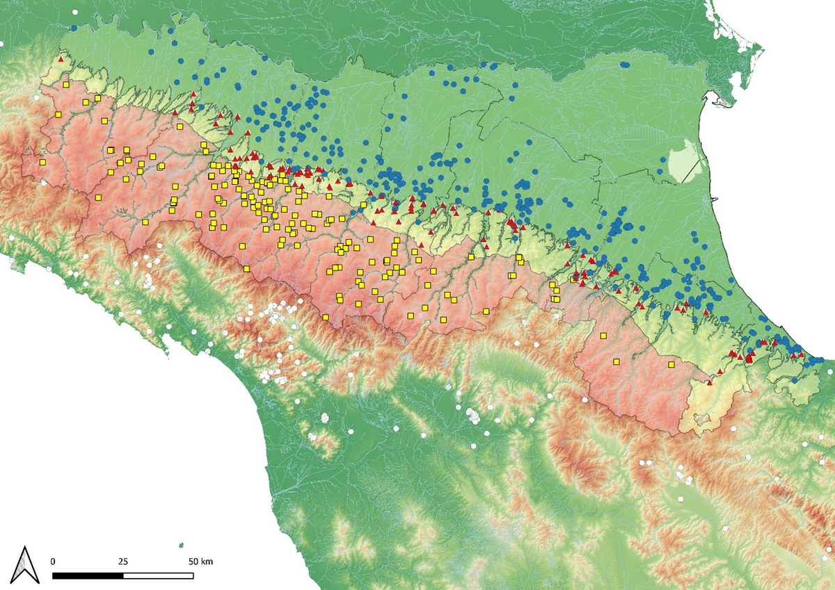
Figure 1. Distribution of the 2nd millennium BC sites in the Emilia Romagna plain, hill and mountain territories.
Since the early stages of the prehistoric research, the lowlands of the Po River valley have been more extensively investigated, compared to the mountain areas. Nonetheless, some Bronze Age sites in the uplands were discovered soon after, posing important questions about the relationship with the plain settlements, most notably the Terramare of the Middle and Recent Bronze Age (1650-1150 BC).
During the 20th century, the archaeological research in the mountains became more and more systematic (Cardarelli and Malnati 2006; Cardarelli and Pellacani 2018; Cavazzuti and Putzolu 2015; De Marchi 2003; Ghiretti 2000, 2003; Guerra 2015; Putzolu 2016; Putzolu and Cavazzuti 2019; Tirabassi 2006). Surveys and rare, though important, excavations progressively integrated a picture that was mostly drawn on occasional finds. The result is that, although the widespread occupation of the uplands during the 2nd millennium BC has been ascertained, the main characteristics of the sites (size, morphology, internal organizations, infrastructures, etc.) remain, to a large extent, obscure. Most of the surface finds, such as small pottery/metal assemblages, have been attributed to Middle/Late Bronze Age settlements, without further stratigraphic validation on the field. Therefore, while votive or cult/religious sites can clearly be identified, sites defined as settlements would need more accurate investigation.
For the first time, we will analyse the population patterns of the Emilia and Romagna mountain areas, also in relationship with the settlement distribution in the plains. For this purpose, we subdivided the regional territory into three main zones: plains, hills and mountains (Fig. 1).
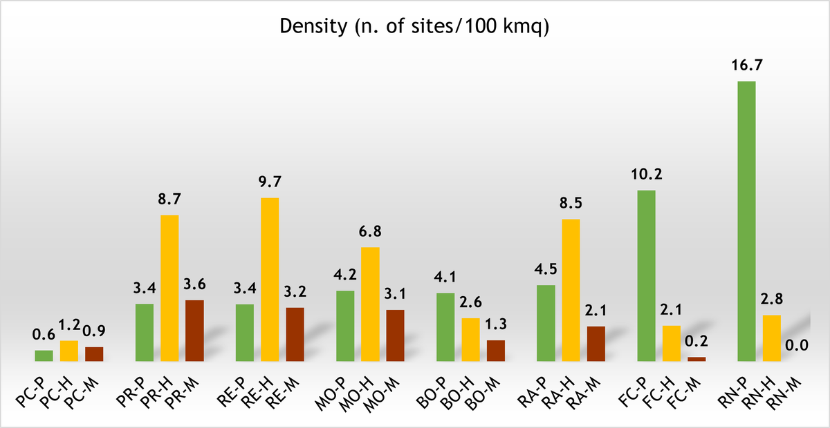
Figure 2. Density of Bronze Age sites in the various provinces of Emilia Romagna (PC=Piacenza; PR=Parma; RE=Reggio Emilia; MO=Modena; BO=Bologna; RA=Ravenna; FC=Forlì-Cesena; RN=Rimini; Ferrara is not present due to the lack of relief), subdivided per territorial zones (P=plains; H=hills; M=mountains).
Currently the territory from Piacenza province to the west to Rimini province to the east counts 292 Bronze Age sites (summing hill and mountain areas), versus 400 in the plain. Both territories can have problems of visibility of sites, such as the presence of thick alluvial deposits in the plain covering the archaeological evidence or the instability of the slopes, as well as dense vegetation, in the uplands. Judging from the current data, the site density in the hill territories appears totally comparable to the plains. Sites become more rarefied in the mountain zone, especially beyond the 800 m a.s.l. (i.e. chestnut tree zone, although the domestication of the species in the Bronze Age is still debated), and extremely rare above 1000 m. The evidence of a broken tanged sword found on the top of the Cimone at 2165 m a.s.l. also highlight the use of highest peaks plausibly for religious ceremonies or votive depositions (Cardarelli 2006).
The distribution of Bronze Age sites in the various provinces of Emilia Romagna, nonetheless, reveals a diversified pattern (Fig. 2). Where the field research has been more intensive, such as in Parma, Reggio Emilia and Modena, we observe comparable density values in the mountain and plain territories. Probably as consequence of a higher visibility or better preservation of the sites, the hill zone shows a significantly higher density. The territory of Piacenza, in all the three zones, is instead characterized by an extremely low density of finds. This seems to be due to a different strategy of occupation of the landscape (Putzolu and Cavazzuti 2019; Del Lucchese et al in press), although a certain impact of less intense research cannot be excluded.
By contrast, the territories of Bologna, Ravenna and Forlì-Cesena, despite a great number of sites in the plains, show a rarefied occupation of the uplands. This pattern seems more explicable by considering the lack of research rather than a real under-population of these areas during the Bronze Age.
As regard to the chronological trend, we can quantify the number of sites per phase, using diagnostic materials, especially metals and pottery forms, handles, decorations. It is important to specify that a considerable number of sites (107 out of 292, namely 37%) in the uplands cannot be dated with precision, although it can reasonably be attributed to the Middle or Recent Bronze Age (1650-1150 BC).
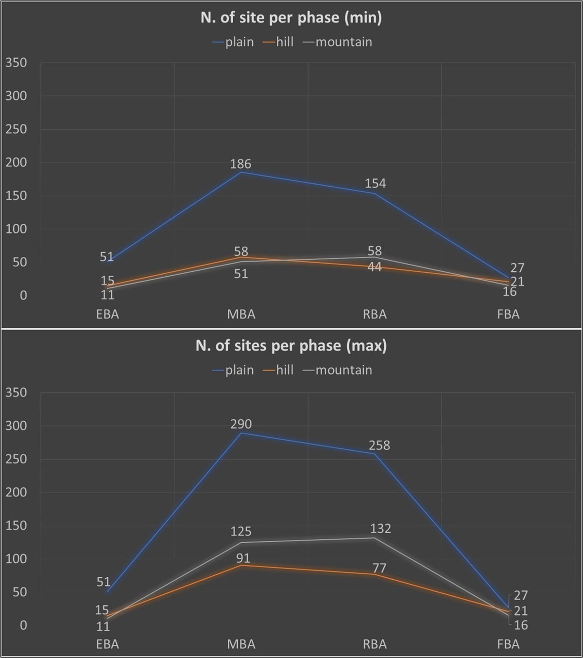
Figure 3. Number of sites per chronological phase (EBA=Early Bronze Age, 2300/2200-1700/1650 BCE; MBA= Middle Bronze Age, 1700/1650-1330/1300; RBA=Recent Bronze Age, 1330/1300-1150; FBA=Final Bronze Age, 1150-950/925).
To overcome the issue of chronological attribution, we produced two pictures, one excluding the above-mentioned sites, and the other considering all of them inhabited during both phases (Fig. 3).
In both cases, the uplands show a trend that is comparable with the plain, with a substantial increase in the number of sites during the Middle Bronze Age, a phase of stability over the Recent Bronze Age and a significant decrease in the Final Bronze Age (1150-950 BC), in concomitance with the collapse of the plain settlement systems, most notably of the Terramare (Cardarelli 2009). Overall, the less radical fluctuations of the upland might be explained with the distinctive characteristics of mountain ecology and economy, characterized by a lower carrying capacity/productivity/demographic potential if compared to the plain, but at the same time by a higher resilience/lower vulnerability to systemic crises. The only chronological phase in which the upland sites outnumber the plain sites is the Final Bronze Age (37 vs 27), or at least the FBA1-2, while the FBA3, similarly to the EIA, is significantly underrepresented. This evidence appears of great interest, as it might explain, at least partially, the response of local communities to the 12th century BC collapse.
Considering the above-outlined scenario, we can try to recapitulate what are the fixed points we can claim to know and what are the possible steps forward to find reliable solutions to open questions.
As already observed in other parts of the peninsula (Peroni and Di Gennaro 1986), an increasing preference for naturally defended locations with high visual control over the surroundings can be noted at least from the advanced phases of the Bronze Age (Cardarelli 2006; Putzolu and Ghiretti 2018; Putzolu and Cavazzuti 2019), but positions on slopes and at the bottom of the river valleys, in more direct contact with the travel routes, also appear to be exploited.
A nearly exact match of Bronze Age settlements and ophiolite formations (in the Taro and Ceno valleys in the province of Parma all sites dated to the 2nd millennium BC are on a ophiolite or in its immediate vicinity) has been emphasized by several authors (Cardarelli and Malnati 2006; Cattani and Monti 1997; Cavazzuti and Putzolu 2015; Ghiretti 2003): on the one hand this has been related to the presence of copper mineralization (albeit often in insignificant quantities), however the landmark function of these imposing and relatively barren rock formations may not have been secondary.
Unlike the Karst hillforts (Castellieri) or the Ligurian ones (Castellari), no defensive structures are currently known from Emilia-Romagna upland sites: the only exception, represented by the settlement of Groppo Predellara in the Parma Apennines, for which the presence of a section of a "megalithic type" walled enclosure is mentioned (Ghiretti 2000, p. 138), could instead be interpreted as the remnant of the terracing works by which the settlement area was artificially increased (Cardarelli 2006, p. 48).
Viewshed analyses undertaken using two different methodologies in the Parma province area (Putzolu 2016; Putzolu and Ghiretti 2018) and the Modena area (Cardarelli 2006) led to the same conclusions, namely that dominance over the surrounding territory was in most cases an aspect of primary importance for settlements. The intervisibility that could be recorded among several of these sites suggests the intention of exercise a widespread control over the river valleys that, in all likelihood, served as a trans-Apennine communication route towards the territories of present-day Tuscany and Liguria. In order to extend the intervisible site systems and viewshed analyses to the entire Emilian Apennines, a more systematic review of the positioning of all known evidence has been planned.
Our general overview of the Bronze Age settlement pattern in the Emilia and Romagna Apennine area suffers of a lack of knowledge of several critical aspects. First, we need to improve fieldwork projects in order to understand the settlement forms, size, spatial organization and infrastructures. Beside excavations, the application of non-invasive geophysical techniques might serve this fundamental purpose. Second, a major investment should be made in paleoenvironmental research, for clarifying not only the characteristic of the natural landscape, but also subsistence strategies of the upland communities. Third, considering mountain areas as a sort of joining belt between different cultural spheres, the theme of mobility, also related to possible vertical/horizontal transhumance, should be explored using updated techniques (e.g. isotope analysis on animal remains).
Bibliography
Cardarelli, A. (2006). L’Appennino Modenese nell’età del bronzo, in Cardarelli, A., & Malnati, L. (2006). Atlante dei Beni Archeologici della Provincia di Modena. Volume I. Montagna. Firenze: All’Insegna del Giglio, pp. 40-68.
Cardarelli, A. (2009). The collapse of the Terramare culture and growth of new economic and social systems during the Late Bronze Age in Italy. In Scienze dell’Antichità Storia Archeologia Antropologia (Vol. 15, pp. 449–519). Roma: Quasar.
Cardarelli, A., & Malnati, L. (2006). Atlante dei Beni Archeologici della Provincia di Modena. Volume I. Montagna. Firenze: All’Insegna del Giglio.
Cardarelli, A., & Pellacani, G. (2018). Il luogo di culto del Bronzo recente di Monte S. Giulia nell’Appennino Modenese. In M. Bernabò Brea (Ed.), Preistoria e Protostoria dell’Emilia Romagna II (pp. 573–579). Firenze: Istituto Italiano di Preistoria e Protostoria.
Cattani, M., & Monti, A. (1997). L’insediamento dell’età del Bronzo nelle valli dei torrenti Dopo e Dragone (Appennino modenese). In M. Bernabò Brea, A. Cardarelli, & M. Cremaschi (Eds.), Terramare. La più antica civiltà padana (pp. 298–291). Milano: Electa.
Cavazzuti, C., & Putzolu, C. (2015). Strategie di occupazione dell’Appennino Emiliano durante l’età del bronzo. In F. Cambi, G. De Venuto, & R. Goffredo (Eds.), I pascoli, i campi, il mare. Paesaggi d’altura e di pianura in Italia dall’Età del Bronzo al Medioevo. Storia e Archeologia globale 2. (pp. 51–71). Bari.
De Marchi, L. (2003). Archeologia della preistoria tra Parmense e Reggiano. L’età del Bronzo nelle Valli Parma, Enza e Baganza, Parma, 2003.
Del Lucchese, A., Lachenal, T., Putzolu, C., & Rubat Borel, F. (in press). L'età del Bronzo in Liguria, lungo le coste e al di là dei monti, in Negrino, F., & Tinè, V. eds. - Preistoria e Protostoria in Liguria, Rivista di Scienze Preistoriche LXX S3
Ghiretti, A. (2000). L’età del Bronzo nelle valli di Taro e Ceno (Appennino Parmense). Padusa, 36, 31–84.
Ghiretti, A. (2003). Preistoria in Appennino. Le valli parmensi di Taro e Ceno. Parma: Step.
Guerra, L. (2015). Strategie insediative, economiche e scambi culturali nell’Appennino Bolognese e Romagnolo nell’età del Bronzo. University of Bologna.
Peroni, R., & Di Gennaro, F. (1986). Aspetti regionali dello sviluppo dell’insediamento protostorico nell’Italia centro-meridionale alla luce dei dati archeologici e ambientali. Dialoghi di Archeologia, 4(2), 187–193.
Putzolu, C. (2016). La valle del Taro nell’età del Bronzo: insediamenti ed organizzazione territoriale. Oxford: British Archaeological Reports - BAR 2814.
Putzolu, C., & Cavazzuti, C. (2019). L’appennino emiliano nell’età del Bronzo: la frontiera meridionale delle terramare. In L. Bronzoni, M. Maffi, P. Mazzieri, & A. Mutti (Eds.), Le quistioni nostre paletnologiche più importanti…Trent’anni di tutela e ricerca preistorica in Emilia occidentale. Atti del Convegno di Studi in onore di Maria Bernabò Brea (pp. 251–264). Piacenza: Archeotravo Cooperativa Sociale - Museo Civico Archeologico di Travo Parco Archeologico Villaggio Neolitico di Travo.
Putzolu, C., & Ghiretti, A. (2018). Il paesaggio dell’età del Bronzo nella porzione montana della valle del Taro. In M. Bernabò Brea (Ed.), Preisoria e Protostoria dell’Emilia-Romagna 2 (pp. 553–560). Firenze: Istituto Italiano di Preistoria e Protostoria.
Tirabassi, J. (2006). Strategie insediamentali nell’appennino reggiano durante l’età del Bronzo, in AA.VV., Studi di protostoria in onore di Renato Peroni, Firenze: pp. 457-470.