- Home
- Project Apri sottomenù
- UPLAND ARCHAEOLOGY WORKSHOP Apri sottomenù
-
Abstracts
Apri sottomenù
- Wieke de Neef (Ghent University / Otto-Friedrich University Bamberg)
- Francesco Carrer (School of History, Classics and Archaeology, Newcastle University (UK))
- Umberto Tecchiati (University of Milan)
- Tesse Stek (KNIR - Royal Netherlands Institute in Rome)
- Riccardo Rao (University of Bergamo)
- Fabio Saggioro, Nicola Mancassola (University of Verona)
- Roberto Maggi, LASA (Laboratorio di Archeologia e Storia Ambientale), University of Genova
- Andrea Cardarelli, Andrea Conte (University of Rome "La Sapienza")
- Federico Zoni (University of Bergamo)
-
Short presentations
Apri sottomenù
- SHORT PRESENTATIONS PROGRAMME
- Putzolu et al., The 2nd Millennium BC in the northern Apennines
- Giorgi et al., New insights into the upland landscape of ancient Epirus, Southern Albania
- Carra, Subsistence economy in the Bronze Age in the northern Apennines upland
- Gaucci et al., Mapping mobility in the Apennines: The Reno Valley between the 6th-4th century BCE and the contemporary period
- Cirelli et al., Insediamenti di altura nell’Appennino Romagnolo e Toscano nel medioevo
- Betori et al., Amatrice: da castello a città
- Del Fattore, Upland landscapes and settlements strategies in the Central-Southern Apennines (1000 BC-2023 AD)
- Conversi et al., The site of Albareto cà Nova
- Bottazzi et al., Attorno al Monte Titano (739 m s.l.m.). Ricerche archeologiche e paleoambientali in Repubblica di San Marino
- Conversi et al., Il sito tardoatico – medievale d’altura della Piana di S. Martino , Pianello Val Tidone (PC)
- Cortesi et al., Archeologia dei paesaggi in una vallata appenninica: il progetto “Val Fantella” (Premilcuore, FC)
- Barbariol, Farms abandonment in Iceland
- Garattoni, Doss Penede (Nago, TN): progettare e costruire un insediamento minore nell’Alto Garda in epoca romana
- Santandrea, Detecting and Mapping Hilltop Sites between the Cesano, Misa, and Nevola River-Valleys
- Bonazzi et al., “Media Valle del Cedrino”: a region between uplands and plateaus
- Zanotti, Back to Monte della Croce
- Monticone et al., Un approccio di archeologia museale al ri-studio del sito neolitico di Chiomonte-La Maddalena (Piemonte, Italia). Revisione ed aggiornamento dei dati dal 1988 al 2023.
- Facciani et al., Exploring the funerary landscape of the Samarkand piedmont area
- Kaur and Poddar, Colonial Churches of Shimla: Public Archaeology as a Tool for Engagement and Outreach
- Datta, Upland Buddhist Monastic Complexes and the Pala Kingdom: Reviewing the Highland-Lowland Relationships in Ancient Bengal
- Staff
- Contacts
- Events calendar
- Seminars Apri sottomenù
- NEWS Apri sottomenù
Santandrea, Detecting and Mapping Hilltop Sites between the Cesano, Misa, and Nevola River-Valleys
Introduction
Marche is a region in central Italy, situated in the external sector of the Adriatic side of the Umbria-
Marche Apennines, a trust-and-fold chain rising up since Miocene. It is characterised by short rivers
with several orders of terraces, deep gullies and narrow alluvial plains. The Cesano and Misa rivers,
including the Nevola torrent, are situated in the northern part of the region and flow orthogonally
to the coastline. The landscape of the Marche region is subjected to continuous changes, which can
be monitored by studying old and modern remote sensing data. The terraces originated during the
uppermost Pleistocene-Holocene, due to the dissection of the alluvial fill (Dall’Aglio, et al., 2012).
During the 3rd century BC, the Romans operated a division of the agri Picenus et Gallicus (lex
Flaminia, 232 BC), which resulted in a massive and growing network of drainage that caused a deep
transformation of the landscape (e.g., the meandering configuration of the rivers). The landscape
started to change again in the 5th and 6th centuries AD, when the Cesano and Misa valleys went
through a process of depopulation (Dall’Aglio, et al., 2012). Caused by both natural (e.g., a climate
cooling) and human factors (e.g., the Gothic Wars in AD 535-553), it led to waterlogging, wasteland,
and hydraulic disruption (Dall’Aglio, et al., 2012). As a consequence, the cultivated area was
replaced by woods and swamps. Eventually, the braided configuration of the rivers in the Cesano
and Misa valleys was restored. In the recent years, the changing rhythm is accelerating due to more
invasive ploughing techniques and a shift in cultivation, from olives and wine to cereals (Boschi,
2020).
In the central-southern area of Marche, many pre-Roman necropolises and settlements were
mapped in the hilltops of the Potenza and Esino valleys, around Ancona and the Conero promontory.
The Cesano, Misa, and Nevola river-valleys, instead, seemed to be less populated. In the Cesano
valley, while traces of settlements have been found on top of plains or river ridges (e.g., Montedoro,
Miralbello), the data about the necropolises is lacking. On the other hand, in the Misa and Nevola
valleys, data about necropolises is abundant, whereas the settlements are still to be mapped
(Boschi, 2022). However, scholars believe this could be related to a lack of systematic studies
(Boschi, 2020).
This project aims at mapping and detecting hilltop Picenian settlements in the river-valleys of the
Cesano, Misa, and Nevola. They will be then connected with known necropolises in the area. To do
so, a holistic approach will be applied, involving the study of cartography, geomorphology, LiDAR,
satellite imagery, and aerial photos. Moreover, this project will focus on identifying markers for the
detection of Picenian settlements, as has been done for the necropolises by Professor Federica
Boschi. To do so, a comparison with geomorphologically similar valleys will be made (e.g., the
Potenza valley). Eventually, field-walking surveys will be conducted to verify promising sites.
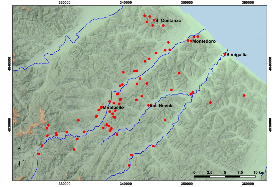
Figure 1. The sites mapped by the University of Bologna in the Cesano, Misa, and Nevola river-valleys (after Boschi, 2020, p. 53).
Methods and Analyses: A Comparison with Previous Research
The effectiveness of a holistic approach has been demonstrated by many scholars (e.g., the Potenza
Valley Survey team of Ghent, the ArcheoNevola project). The University of Bologna is working in the
Cesano, Misa, and Nevola river-valleys since the early 2000s. Aimed at evaluating the buried
archaeological record and contextualising the necropolises, the project consisted of an integration
of old and new data. The techniques used included toponymy, documentary, and literal sources,
trial digs, field-walking surveys, aerial photography, and geophysical surveys. Among the geophysics
appliances used, geomagnetic prospections and resistivity resulted to be the most performing in the
area. GPR was almost unsuccessful because of the clayey soil (e.g., in Suasa), as has been also proved
by the Potenza Valley Survey team (De Neef, 2020). The Potenza Valley Survey (PVS) is an ongoing
project of Ghent University focused on the population of the Potenza valley. Even though its primary
aim was better understanding the settlement record during the Roman period, was then extended
to pre-Roman population. The research was carried out through non-invasive prospections, with a
particular focus on geo-archaeological studies (De Neef, 2020).
Following the example of both teams, the first step of this research will be an integration of data
from ancient and modern aerial pictures, satellite imagery, and LiDAR.
A GIS to compare the results of the analyses and to monitor the changes in the landscape will be
created. Particular attention will be given to the orography of the selected valleys, to detect the
hilltops more favourable for Picenian settlements.
The research will also focus on identifying a settlement pattern in order to implement the
investigations conducted by the ArcheoNevola project and the recently launched project SEnsing
ARCHaeology. Non-invasive mapping and tracking technologies for evaluating and protecting buried
archaeology (coordinated by F. Boschi). According to the investigations undertaken so far, the
annular ditches, identified as Picenian funerary contexts, are characterised by a sharp circular shape
of twenty to thirty m diameter (Boschi, 2022). These sites share some peculiarities: the geographic
position, extension, and shape. They were set in a crucial point for road and fluvial systems: near
road axes, the confluence of two rivers, and fords. Another marker is related to the extension of the
site, which usually covers the totality of the plain. Their measure is standard, varying from 15 to 30
meters. The cluster disposition is the most common one. Monuments have been found in the
funerary sites. They were usually delimited by circular ditches, covered with mounds or deposits of
soil and stones, both made with excavated soil. Due to their position, necropolises have been
hypothesized as pivotal places that could have had several connotations, among which certainly a
value as territorial markers (Boschi, 2022). Together with the topographical position of the
necropolises, another analogy is the continuity of occupation of the sites, or, possibly, a longstanding
occupation and use of the site. The necropolises were also used by the Romans (from the
2nd to the 4th centuries AD). The same peculiarities are shared also by other areas of Marche. For
example, Monte Franco, a site investigated by the PVS, is situated in a strategic position: the Potenza
River crosses through the ridge at Passo di Treia, providing an east-west and north-south crossroads
connecting the Appenine inlands, river valley, inland hill ranges, and coastal zone (De Neef, 2020).
As the presence of markers has been demonstrated for the Picenian necropolises, it is expected to
find similarities for settlements too. The most important sites in the Cesano valley are Montedoro
and Miralbello. The latter is sited on a plateau at about 174 m above the sea and provided traces of
occupation from the Bronze and Iron Ages to the Middle Ages (Gaucci, 2020; Giorgi, 2020a). Two
concentric ditches of 200x100 m, containing regular features interpreted as structural elements,
were mapped using geophysics. The site was also subjected to a field-walking survey, that shed light
on impasto pottery attributed to the Picenian tradition (Giorgi, 2020b; Boschi, 2020).
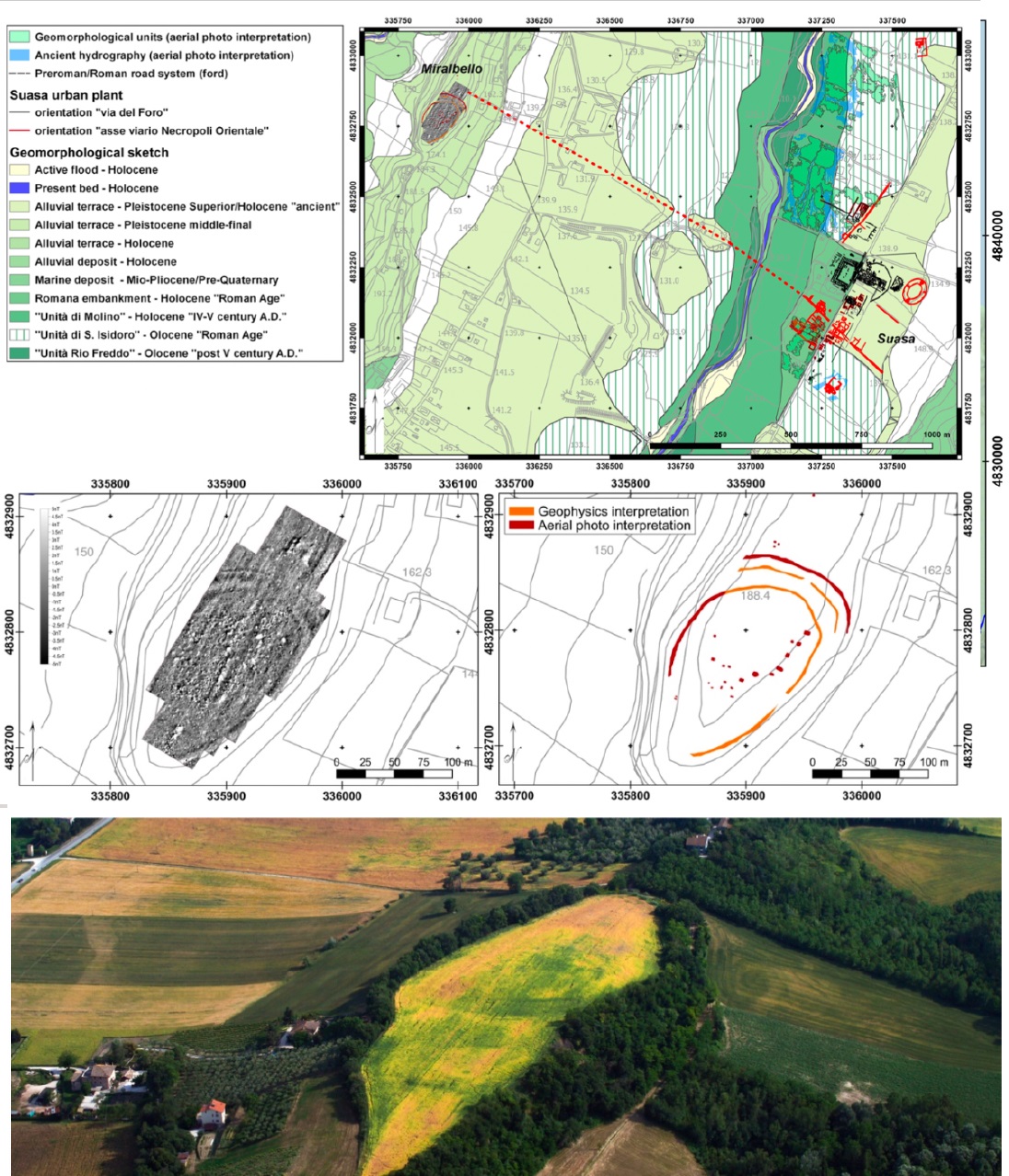
Figure 2. The site of Miralbello (after Boschi, 2020b, p. 58).
Montedoro is located on a hilltop too, about 100 m.a.s.l. It dominated the mouth of the Cesano river
and was highlighted as an active settlement from the early Iron Age up to the 5th century BC.
However, its river port is believed to have survived even longer. In the 4th century BC, the site was
substantially abandoned (Gaucci, 2020).
Moving to the Potenza valley, the site of Montarice is sited on a flat elliptical hilltop plateau of seven
hectares. The site was occupied since the Middle Bronze Age (as confirmed by impasto pottery) until
the Republican times. The plateau was surrounded by defence structures, such as walls or ditches.
Traces of the “village” have been found in the nearby valley floor, near the river beach. This could
suggest a commercial use, to facilitate contacts with the area of the Monte Conero and the valley
corridor (De Neef, 2020).
Conclusions
Most of the information relative to the Picenian population comes from the necropolises.
Settlements and economy, on the other hand, remain largely unknown (De Neef, 2020). As
demonstrated by previous research in Marche region, a holistic approach is the most effective
technique to map hilltop sites and gain a better understanding of the area. After the analysis of
aerial pictures, LiDAR, and satellite imagery to identify promising sites, markers of Picenian
settlement trends will be investigated. To do so, a comparison between with geomorphologically
similar valleys (e.g., the Potenza valley) will be made. By comparing three different sites, Montedoro
and Miralbello (in the Cesano valley), and Monterice (in the Potenza valley), a first hypothesis can
be made. All the analysed settlements were sited on hilltops or plateaux. Moreover, they were set
in strategic positions (e.g., at crossroads or fords), probably because of the possibility of commercial
contacts with the surrounding areas. Another marker could be the presence of defence structures
(probably walls and ditches) surrounding the site. An integrated approach and systematic surveys
would lead to a stronger knowledge of the area, including spatial organisation, and changes in the
landscape (as highlighted in De Neef, 2020). Moreover, it would guarantee future well-targeted
excavations.
Bibliography
Boschi, F. 2020. Methodological approaches to the study of the Cesano and Misa River Valleys (2010-
2020). New data: some thoughts and perspectives, in Boschi et al. 2020. Picenum and the Ager
Gallicus at the Dawn of the Roman Conquest. Oxford: Archaeopress, pp. 47-60.
Boschi, F., 2022. Paesaggi funerari sepolti. Un contributo allo studio delle necropoli picene nelle
Marche settentrionali. Atlante Tematico di Topografia Antica, (32), pp. 161-180.
Dall’Aglio, P.L., et al. 2012. Ancient landscape changes in the North Marche region: an archaeological
and geomorphological appraisal in the Cesano valley, in XXXIIe rencontres internationales
d’archéologie et d’histoire d’Antibes. Antibes: Éditions APDCA, pp. 101-112.
De Neef, W. 2020. A crossroads in the central Potenza Valley: non-invasive research into settlement
(dis-)continuity at Monte Franco (Pollenza, Marche, Italy), in Boschi et al. 2020. Picenum and the
Ager Gallicus at the Dawn of the Roman Conquest. Oxford: Archaeopress, pp. 135-144.
Gaucci, A. 2020. Perspectives on the analysis of the settlement system in medio-Adriatic Italy
between the late sixth-fifth and fourth centuries BC: the case study of the Cesano and Misa river
valleys, in Boschi et al. 2020. Picenum and the Ager Gallicus at the Dawn of the Roman Conquest.
Oxford: Archaeopress, pp. 91-97.
Giorgi, E. 2020a. Suasa: Genesi e sviluppo di un municipio romano dell’Agro Gallico. Atlante
Tematico di Topografia Antica, (30), pp. 95-114.
Giorgi, E. 2020b. The Cesano Valley at the outset of Roman conquest and the genesis of Suasa, in
Boschi et al. 2020. Picenum and the Ager Gallicus at the Dawn of the Roman Conquest. Oxford:
Archaeopress, pp. 61-80.
Highlights
-
Teodora Santandrea, University of Bologna