Butrint Atlas
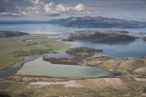
picture by Pierluigi Giorgi
Buthrotum, also known as Bouthrotos, is located in the southern area of present-day Albania, near the border with Greece. Part of the historical region of Chaonia, Butrint stands at the end of the Ksamil peninsula, surrounded by the Butrint Lake and the Vivari Channel, which separates the promontory from the overlooking alluvial Vrina Plain. The territory of the city developed as a consequence of the deposition of alluvial sediments carried by a large estuary including both the valley on the north and south sides of Butrint. While the rise of the sea level decreased and the accumulation of alluvial debris intensified, the connection between the estuary and the sea gradually disappeared. Lake Butrint therefore remains the only evidence of this large bay where the water courses flowed, while the coasts once directly in contact with the sea are now a marshy environment.
The center developed in a favourable position for the access to a hinterland rich in natural resources, for connections with the cities located further north, and for the control of routes and commerce towards Greece and the Adriatic and Ionian seas. It should come as no surprise that the area of the city was first occupied during the late Bronze Age and exploited until the fall of the Ottoman empire, leaving behind a long and articulated history and a highly stratified settlement.
The Atlas of the city is designed as an instrument to help students and scholars approach Butrint and its monuments. The aim is not only to help the scientific community, as well as anyone interested, get in contact with this site, but also to list the fundamental and updated bibliography for each of its monuments, result of almost one century of international excavations and research.
Unless otherwise stated, all the pictures are intended as part of the Photographic Archive of the Archaeological Mission.
Sanctuary of Asclepius
Leggi dettagli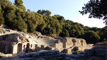
The Sanctuary of Asclepius was built between the end of the 4th century and the beginning of the 3rd century BC, and then enlarged after the Roman conquest. It was the heart of the city, not only for its religious importance but also because it became the administrative centre, first of the koinon of the Epirotes and then, from the 2nd century BC, of the koinon of the Prasaiboi. The multi-level organisation of the Sanctuary was exploited to fulfil its double vocation: the lower level probably played a public role, while the upper level was devoted to the healing practices.
It is likely that, before the Roman rearrangement, pilgrims had three ways of accessing the sanctuary:
• from east, following the low profile of the southern side of the acropolis;
• from the Vivari channel, through the door of Asclepius;
• from the isthmus, crossing the western side of the acropolis in order to reach the treasure or descend from the acropolis to reach the southern end of the complex.
After the foundation of the colony, the sanctuary probably lost its political role becoming an exclusively religious centre, at least until the 4th century AD.
It is interesting to note that the toponym of Butrint is often linked to the cult of Asclepius in the dedicatory formula τωι Ασκλαπιωι τωι εμ Βουθρωτωι. Asclepius seems to be the only divine figure with which the political community identifies itself, despite the presence of cults devoted to other divinities, such as Zeus Soter.
The whole complex of the Sanctuary has been studied by the Butrint Project in 2015 and 2016 through a topographical survey using the Laser Scanning method in order to valuate the state of its conservation and deterioration.
Greek Agora and Roman Forum
Leggi dettagliBeing first a Greek and then a Roman city, Butrint must had its civic centre. The Agora was built in close proximity with the Sanctuary of Asclepius once the area resurfaced in the late Hellenistic age. It was later restructured and reorganised after the deduction as Roman colony, as it is shown by the construction of the Forum and the numerous surrounding buildings, which uses many of the Greek materials and structures. The Forum later underwent several phases of employment and reconstruction up to the 16th century AD.
As centre of the city and probably one of the best preserved of its kind in the provinces of the Roman Empire, the excavation of the Roman Forum has been fundamental for understanding the history of the whole site and its complex stratification.
Acropolis
Leggi dettagli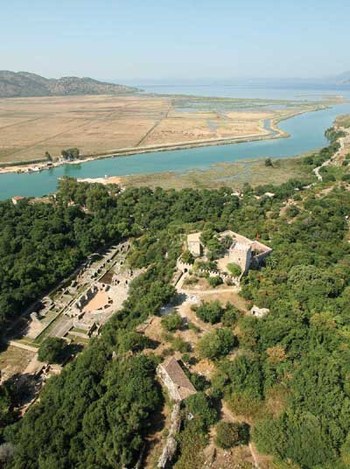
The acropolis of Butrint is a 200 m and 60 m wide long, bared hill, rising 42 m above sea level. It can be divided into three different parts: the western terrace with the Venetian Castle; the central terrace, directly over the lower city and the Sanctuary of Asclepius; the eastern terrace facing the Pavllas Valley and the lake.
It was occupied throughout all the long history of the city. The numerous excavations conducted here have collected testimonies of seamless occupation from the very first settlement up to the last Venetian stronghold, making Butrint an exceptional site in the context of Chaonia.
In 2019 the Butrint Project started new excavations in proximity of the Archaic wall circuit on the central terrace of the Acropolis, while also continuing the topographical survey of the Archaic walls using the Laser Scanning methodology.
Image from the website of the Butrint Foundation
Tower of Inscriptions
Leggi dettagli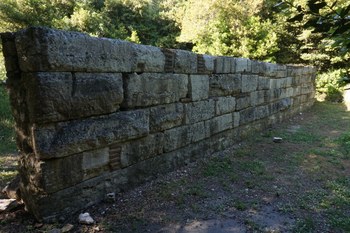
During his excavations in 1976-77, D. Budina found near the walls west of the Tower Gate a tower built using many inscribed blocks coming from preceding structures. This was the reason why it took the name of Tower of Inscriptions. The blocks were cut to obtain a regular form or they were turned upside down in most of the cases. The tower was 7x5 m and preserved to a height of three to fours courses. The inscriptions mostly deal with manumissions of slaves and they refer to the presence of the strategos and prostates of the Prasaiboi and the priest of Asclepius. A dedication to Pan was found as well.
It seems that all these inscriptions can be dated between the 2nd and the 1st century BC, so the Tower must have been built after, probably between the end of the 1st century BC and the beginning of the 1st century AD.
Following Budina's excavation, the inscriptions inserted in the Tower were all assembled for display in the so-called Wall of Inscriptions, shown in the picture.
Near the Tower of Inscriptions there is also another Nymphaeum or fountain, with an apsidal plan. It can be dated to the late Roman period, and it was fed by the aqueduct passing to the north of the structure, along the walls.
Bibliography on the subject
• Benfatti M., Castignani V., Pizzimenti F., "Le fortificazioni di Butrinto: nuove acquisizioni topografiche e stratigrafiche" in Caliò, Gerogiannis, Kopsacheili, Fortificazioni e società nel Mediterraneo occidentale, Roma, 2020, pp. 183-200
• Cabanes P., "Le cult de Pan à Bouthrotos" in Revue des Études Ancienne", vol. XC, 1988, pp. 385-388
• Drini F. and Budina D. "Mbishkrime të reja të zbuluara në Butrint / Nouvelles inscriptions découvertes à Butrint" in Iliria, vol. 11, n°1, 1981, pp. 227-234
• Karaiskaj G., Crowson A. (edt), The fortifications of Butrint, English edition of Butrinti dhe fortifikimet e tij (Tirana 1986), London-Tirana, Butrint Foundation, 2009, pp. 58-59
Gymnasium complex
Leggi dettagli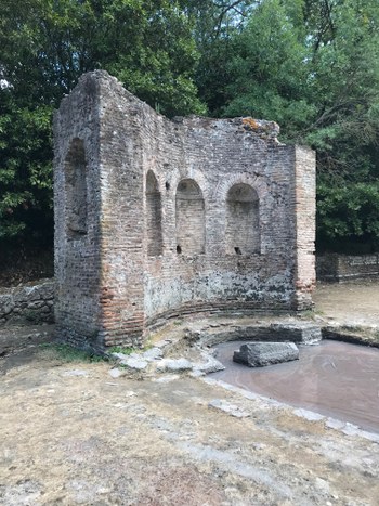
The complex, paved with mosaics, was defines as Gymnasium by P. Marconi because of the vast room that occupied the central space of the building and that was interpreted as a place for physical exercises. This interpretation was rejected by D. Mustilli, however he did not propose any other function for the complex. It was probably built in the 2nd century AD around an Augustan era tomb by a wealthy inhabitant of the city. The entrance is on the west side and leads to a room with an exedra, once decorated with marble slabs. At the centre there is a little nymphaeum, the one in the picture, characterised by three niches on its side with the face of Dionysus and shoots inside their vaults.
The area of the fountain/nymphaeum was later devolved to the Christian ritual. Three niches on the eastern apsidal end of the building decorated with mosaics depicting a kantharos flanked by birds are dated to its first phase, during the Late Antiquity. In the Middle Age, a small church was built here, demolished by Mustilli to reveal the Roman structure beneath. The church was rectangular, it had two entrances in its lateral walls and a bell tower on its northern side. There was also a small northern room, whose roof was supported by a series of piers that projected up from the exterior wall. The lower part of the apse were covered with geometric paintings, while the earlier mosaics in the niches of the apse were covered by layers of plaster.
Bibliography on the subject
• Bowden W., Mitchell J., "The Christian topography of Butrint" in Hodges, Bowden and Lako, Byzantine Butrint: excavations and surveys 1994-99, Oxford, 2004, pp. 104-125
• Korkuti M., Baçe A., Ceka N., Harta Arkeologjike e Shquipërisë, 2008, pp. 77-78
• Mustilli D., "Relazione preliminare sugli scavi archeologici in Albania (1937-1940)", in Reale Accademia d'Italia. Rendiconti della classe di scienze morali e storiche, f. 12, series VII, vol. II, Roma, 1941, pp. 691-695
Triconch Palace
Leggi dettagli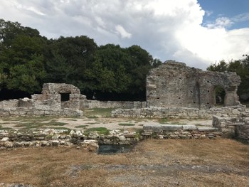
This is a Late-Roman domestic complex. It was discovered during the first archaeological mission led by Ugolini and then excavated first in the 1980s by the Albanian Institute of Archaeology and in the 1990s/2000s by the Anglo-Albanian Archaeological Mission.
In the early 4th century AD a large domus belonging to a wealthy family was built around a peristyle courtyard over the remains of earlier structures, probably residential, dated to the 3rd century. The plan of the domus was defined by the earlier structures and centred around a rectangular space, delimited by piers and flanked on the southern and western sides by rooms, which often show remains of floor mosaics. It is not clear if other rooms were on the northern and eastern sides or not. The southern side opened on the Vivari Channel and it had access to the waterfront, which could mean it had some kind of commercial or maritime function. it was also the richest part of the early residence, probably the quarter where the owner lived: it had a small bathhouse with a double-apsed octagonal vestibule and opus sectile floor and there was also a public reception room (probably a triclinium or an audience chamber) with a long corridor.
During the 5th century the whole complex was expanded to the east and north, where a new portico was build, probably as a consequence of a change in the ownership of the place. The structure entrances were moved on the northern and southern sides. The peristyle was enlarged and a three-apsed triclinium was added on the eastern side, the Triconch from which the building takes its name. Built using small limestone lumps with a mid-wall bonding course of broken tiles, it was located on the central axis of the new peristyle, from which it was entered via a central doorway. All the three apse had niches, presumably for statues, and the southernmost also had a window. They were probably covered by domes. Around the triclinium there were several smaller rooms, all accessible from the triconch itself, among which there is also a little chapel. It is likely that the construction was not finished because of the new wall circuit, which interrupted the direct connection between the Palace and the channel to the south. It seems that in this area of the city the wall circuit was erected by connecting together earlier Roman buildings, which gave it an uneven appearance.
At the beginning of the 6th century the Triconch Palace was used as small-scale industry for the processing of mussel and the disposal of domestic rubbish. It was mostly used by fishermen: hearths and kilns were constructed in the central room of the South wing and fishhook and needles were found here. The layers of shellfish and debris are interspersed with rubble and broken rooftrees. The absence of complete tiles suggest that the place was robbed and demolished little by little rather then destroyed. After the half of the 6th century until the end of the 7th century, starting from the north wing oh the house, the site functioned also as a burial place. Signs of activity can be detected again in the 11th century. The area was not abandoned from the end of the 15th century. The latest coins are dated between the 15th and the 17th centuries. The last structure occupied in Triconch area was the Merchant's House, which became a rubbish dump in the late 15th and early 16th century. It seems that the rubbish was connected to the occupation of the nearby headland fortification tower, which collapsed at the end of the 16th century.
Bibliography on the subject
• Bowden W., Butrint 5. Life and Death at a Mediterranean port. The non-ceramic findings from the Triconch Palace, Oxbow Books, 2020
• Bowden W., Hodges R., Lako K., "The Anglo-Albanian Project at Butrint / Rezultate të projektit anglo-shqiptar në Butrint" in Iliria, vol. 28, 1998, pp. 275-321
• Bowden W., Hodges R., Lako K., "Roman and late-antique Butrint: excavations and survey 2000-2001" in Journal of Roman Archaeology, vol. 15, 2002, pp. 199-229
• Bowden W., Hodges R., Butrint 3. Excavations at the Triconch Palace, Oxbow Books, 2011
• Gilkes O., Lako K., “Excavations at the Triconch Palace” in Hodges, Bowden and Lako, Byzantine Butrint: excavations and surveys 1994-99, Oxford, 2004, pp. 151-175
• Hernandez D. R., "The abandonment of Butrint. From Venetian enclave to Ottoman backwater" in Hesperia, vol. 88, 2019, pp. 365-419
• Moorhead T. S. N., "The Ancient and Early Mediaeval Coins from the Triconch Palace at Butrint, c. 2 nd century BC–c. AD 600." in The Numismatic Chronicle, vol. 167, 2007, pp. 287-304.
• Reynolds P., "The Roman pottery from the Triconch Palace" in Hodges, Bowden and Lako, Byzantine Butrint: excavations and surveys 1994-99, Oxford, 2004, pp. 224-269
• Reynolds P., "The medieval amphorae" in Hodges, Bowden and Lako, Byzantine Butrint: excavations and surveys 1994-99, Oxford, 2004, pp. 270-277
• Vroom J., "The medieval and post-medieval fine wares and cooking wares from the Triconch Palace and the Baptistery" in Hodges, Bowden and Lako, Byzantine Butrint: excavations and surveys 1994-99, Oxford, 2004, pp. 278-292
Baptistery
Leggi dettagli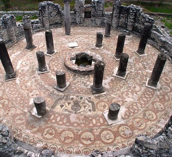
The baptistery was discovered by Ugolini in 1928. It seems that the first nucleus was built between the end of the 2nd and the beginning of the 4th century AD, however it is almost impossibile to describe these early structures in a more detailed way, since few remains of them are left today. In the 4th and 5th century the complex was used as a thermal bath, in fact a small calidarium was built on the south-east corner, whose hypocaust is still visible under a later surface, and a small piscina stood in one corner. Slightly later, an apsidal structure was built north-west of the calidarium, it was probably part of the bath complex serving as nymphaeum or fountain at one end of a palaestra or frigidarium. It used the same water supply of the later baptistery fountain, a large cistern on the east corner. The apse could also be part of a cult building.
This apse was destroyed and substituted by an oval structure, still visible beneath the rear of the baptistery fountain. Around the second quarter of the 6th century, a series of other constructions and demolition operations followed this one, and created the structure where the baptistery was built. The circular building had a squared exterior and its eight radiating columns (re-erected by Ugolini), font and the famous mosaic floor were all part of one building program. It is built with coursed limestone rubble. Between the columns there are low benches, which were faced with marble panels, however nothing remains of these, even though Ugolini reported discovering numerous marble panels. The principal entrance was on the southwest side of the building. The doorway used a large lintel from an older structure. A trapezoidal room on the north-west side of the baptistery was probably constructed in the same period. For what concerns the mosaic, it is formed by seven circling bands turning around a marble-revetted cruciform font at the centre. The first and the fifth band depicts ivy scroll, the second and the fourth interlocked medallions inhabited with terrestrial quadrupeds, birds, fish, and plants; the third and the sixth represent fascias of ring-interlaced, while the seventh depicts interlocking medallions with chequer-board lozenges. This composition is interrupted by two emblem lying on the axis between the font and the entrance and representing two peacock in a vine and two deer drinking from a fountain.
In the late 6th or early 7th century, the occupation pattern of the area changed. The first graves were dug in the course of this century and walls were built within the first buildings. From the half of the 7th century to the 10th century, it seems that the are was not occupied: the baptistery probably collapsed and new graves were cut on the levelled remains of the walls. New structures were built between the 10th and the 12th century, however there are no remains of them apart from several coins. From the 13th century, the area was mostly used as graveyard, which can probably be linked to the construction of the first medieval churches to the north-west of the baptistery. During the 14th and 15th century the church was rebuilt in its present form, with the narthex and the bell-tower. The evidences found in the Baptistery show the last phase of occupation between the 15th and the early 16th century.
Two other buildings near the Baptistery were identified as Venetian by Ugolini on the basis of their masonry.
There is a vaulted building with concrete barrel-vaulted rooms and groin-vaulted ceilings. It was built between the 14th and the 15th century, but it is not clear whether before or after the Venetian conquest of the city in 1386. Its proximity to the shore and fortification circuit lead to the interpretation of the building as a warehouse, a place where military equipment, agricultural products or salt for the fishery were stored.
The other building is located north-east of this and has been interpreted as a mill or a place for some kind of industrial production. It seems quite certain that this building was not a dwelling, however it is impossible to determine its purpose or dating.
Bibliography on the subject
• Bowden W., Hodges R., Lako K., "The Anglo-Albanian Project at Butrint / Rezultate të projektit anglo-shqiptar në Butrint" in Iliria, vol. 28, 1998, pp. 275-321
• Bowden W., Përzhita L., “The Baptistery” in Hodges, Bowden and Lako, Byzantine Butrint: excavations and surveys 1994-99, Oxford, 2004, pp. 176-201
• Hernandez D. R., "The abandonment of Butrint. From Venetian enclave to Ottoman backwater" in Hesperia, vol. 88, 2019, pp. 365-419
• Mitchell J., “The mosaic pavements of the Baptistery” in Hodges, Bowden and Lako, Byzantine Butrint: excavations and surveys 1994-99, Oxford, 2004, pp. 202-218
• Mitchell J., Pagëzimorja e Butrintit dhe mozaikët e saj / The Butrint Baptistery and its Mosaics, London-Tirana, Butrint Foundation, 2008
• Mustilli D., "Relazione preliminare sugli scavi archeologici in Albania (1937-1940)", in Reale Accademia d'Italia. Rendiconti della classe di scienze morali e storiche, f. 12, series VII, vol. II, Roma, 1941, pp. 677-704
• Reynolds P., "The medieval amphorae" in Hodges, Bowden and Lako, Byzantine Butrint: excavations and surveys 1994-99, Oxford, 2004, pp. 270-277
• Ugolini L. M., Butrinto. Il mito di Enea. Gli scavi, Istituto grafico tiberino, 1937, pp. 159-164
• Vroom J., "The medieval and post-medieval fine wares and cooking wares from the Triconch Palace and the Baptistery" in Hodges, Bowden and Lako, Byzantine Butrint: excavations and surveys 1994-99, Oxford, 2004, pp. 278-292
Great Basilica
Leggi dettagli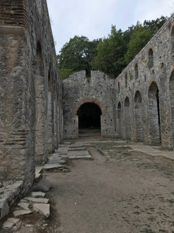
The main Late Antique church of Butrint is located in the northeastern side of the peninsula, near the Tower Gate and close to the bridge connecting the town to the settlement on the Vrina Plain. This part of the city was particularly important given its role as gateway into the settlement. This perception persisted during Late Antiquity, when the Basilica was built in the site of a Roman structure, probably a cistern part of the aqueduct, whose limestone blocks are still visible beneath the apse. L. M. Ugolini was the first to study this church, however the first complete examination of the structure was carried by A. Meksi between 1974 and 1975 as part of a restoration project.
The church, oriented east-west, was built between the end of the 5th century and the beginning of the 6th century AD. It was characterised by three aisles, a tripartite transept and a pentagonal apse, which was hemispherical on its interior face. The apse, the transept, and part of the façade and side walls are still preserved as they were in the original building, while the clerestory, slab pavement and the piers dividing the aisle are the result of a later reconstruction. Bowden and Mitchell believe that originally the aisles were divided from the nave by colonnades, while piers divided the bays of the transept. Molla, on the other hand, believed that masonry piers rather than columnar arcades and stylobate walls. There are not many evidences of the colonnades, apart from the column bases and some Corinthian capitals. The columns were surmounted by arches, which had the peculiarity of being built using twice thick tiles. At the centre of the nave has been found also a foundation made of mortared limestone rubble within the centre of the nave, which may be the remains of an ambo.
The walls of the Basilica were built using coursed limestone rubble interspersed with regular string-courses of brick or tile. Some parts of the walls were decorated with incised circles and interlocking triangles. There are remains of the pavement mosaic too, depicting trailing ivy tendrils and scrolling guilloché, similar to the Baptistery mosaic. It is likely that the church functioned in conjunction with the Baptistery and that was equipped with two access points on the side facing the Baptistery, in order to facilitate the passage. They may have been both constructed by Butrint’s episcopacy, first documented in 484.
The pentagonal apse had an axial wall dominated by a five-lobed window extending onto the angled walls on either side. The sanctuary was slightly raised above the floor level of the church.
During the reconstruction of the church, the colonnades were replaced with masonry piers and part of the façade was rebuilt as well. A new floor made of limestone slabs was laid in the nave, aisles, and transept, over the earlier mosaic. The upper section of the apse was rebuilt in a semicircular form with new window arches springing from the earlier pentagonal structure. The date of this renovation is still debated: Meksi believed it to be the later 9th century, in correspondence with the re-establishment of the bishopric, while the archaeologists of the Butrint Foundation believe that this second phase of the Great Basilica could be dated as late as the 13th century.
There are evidences for even later renovations, which are, however, difficult to date. They only suggest a continuity of use during Byzantine and Venetian times. These are a smaller tribal window surmounted by a singolar window that replaced the axial window in the apse; some of the nave arcade were blocked; a small apse was built blocking the access between the southern aisle and the southern transept. Probably the transept bays were abandoned or less used during the last phase of activity of the church.
Bibliography on the subject
• Bowden W., Epirus Vetus. The Archaeology of a Late Antique Province, London, 2003, pp. 105-160
•Bowden W., Mitchell J., "The Christian topography of Butrint" in Hodges, Bowden and Lako, Byzantine Butrint: excavations and surveys 1994-99, Oxford, 2004, pp. 104-125
• Mekis A., "Bazilika e madhe ehe baptisteri i Butrintit" in Monumentet, n. 25, pp. 47-75
• Molla N., "The Great Basilica: a reassessment" in Hansen, Hodges, Butrint 4. The archaeology and history of an Ionian town, Oxbow Books, 2013, pp. 202-214
• Ugolini L. M., Butrinto. Il mito di Enea. Gli scavi, Istituto grafico tiberino, 1937, pp. 172-173
Nymphaeum
Leggi dettagli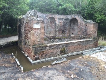
The Nymphaeum is located in an area paved with white limestone slabs and limited to the north by the Great Basilica. Excavated by L. M. Ugolini, it was built during the 2nd century AD, as the opus testaceum testify. It was a monumental fountain formed by a semicircular pool facing east on the street leading to the Tower Gate. It is still preserved in a very good state of conservation. On its circular wall there are three niches: the central one had a cloister vault and the lateral ones barrel vaults. A ditch and a parapet made of stone slabs enclosed the structure. Water came from a barrel-vaulted cistern located behind the the building, on its western side, and directly linked to the Augustan aqueduct, which was probably faced by another fountain on the opposite side in order to enact the same scenic effect present in Nicopolis. The whole monument was constructed using brick-faced concrete and covered in coloured marble slabs.
Two statues lying face down were found in the Nympheum, a young Dionysus and Apollo, probably held in the central and left niche, respectively.
Four of the best preserved aqueduct piers are visible near the Nymphaeum, following the line of the wall circuit and linked to a cistern located between the Great Basilica and the Tower Gate. The dating of the piers has the 1st century BC as terminus post quem, derived by the findings of late Republican amphorae.
Bibliography on the subject
• Martin S., "The topography of Butrint" in Hodges, Bowden and Lako, Byzantine Butrint: excavations and surveys 1994-99, Oxford, 2004, pp. 76-103
• Ugolini L. M., Butrinto. Il mito di Enea. Gli scavi, Istituto grafico tiberino, 1937, pp. 150-151
• Ugolini L. M., L‘acropoli di Butrinto, Roma, 1942, pp. 81-90
• Wilson A., "The aqueduct of Butrint" in Hansen, Hodges, Leppard, Butrint 4. Archaeology and history of a Ionian Town, Oxford, 2013, pp. 77-96
Hellenistic Building and Northeast Church
Leggi dettagli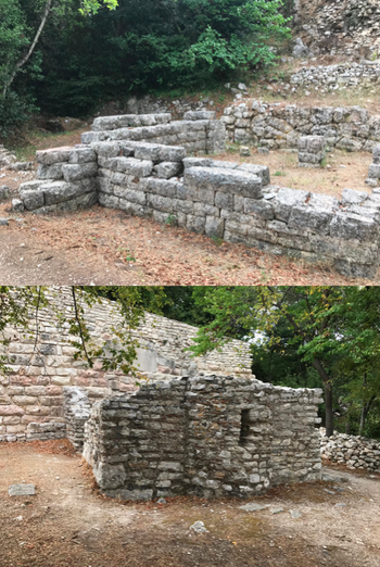
The Hellenistic Building and the so-called Northeast Church are located against the Medieval wall that connects the lower wall circuit with the acropolis wall on the northeast side of the city, near the lake.
The Hellenistic Building is made of large blocks, whose technique is quite similar to the one of the wall circuit, and for this reason the structure was dated to the 2nd century BC. It is formed by a rectangular room placed against the city wall. The entrance is through two rooms on the west side. It was interpreted as a workshop or a shop. In front of the building there was a large terrace wall constructed of polygonal blocks, probably part of a ramp for a roadway running up the side of the hill.
The small Church, probably built in the 13th century, is still preserved for the most part. It is a single-celled structure made of limestone blocks, with a small centrale apse pierced by a single window and flanked by two niches. The entrances were on its southern and northern sides, were the remains of painted plaster are still visible, as well as in the apse. From the scheme of the flanking walls, it seems that framed images of saints were painted here, as it can be detected from the visible remains of feet and draperies. The most preserved part in on the south wall, between the door and the west end of the building, were two phases of paintings have been detected.
Bibliography on the subject
• Bowden W., Mitchell J., "The Christian topography of Butrint" in Hodges, Bowden and Lako, Byzantine Butrint: excavations and surveys 1994-99, Oxford, 2004, pp. 104-125
• Ceka N., Buthrotum : its history and monuments, translated into English by Pranvera Xhelo, Tirane - Migjeni, 2006
Colombarium
Leggi dettagli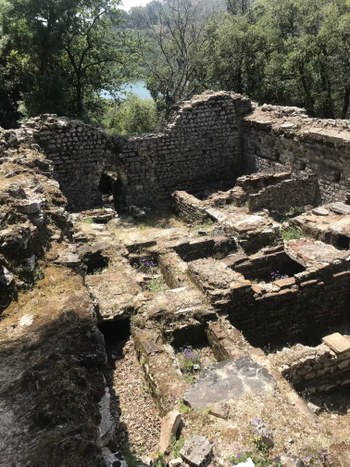
It was Ugolini who discovered the Colombarium near the Lion Gate. He believed that it was a Roman bath reused as necropolis in the 5th century AD. The material found during its excavation were scattered over the years, which makes it difficult to suggest a more precise date. Nevertheless, Ugolini's dating seems to be right after confronting it with other buildings in the city. However, the Colombarium was never used as thermal baths.
The structure was built using irregular opus vittatum, it has a rectangular plan, oriented north-south, and four buttresses along the sides. Probably it once had barrel vaulted roof in cement of considerable size, which makes the presence of the buttresses essential to bear the weight of the roof, as well as of the central diaphragm which offered further support to the vault by unloading its weight on three pillars connected by arches placed in the middle of the room (two against the walls and one central). This means that the structure had two connected rooms, which became more and more independent while the numbers of funeral niches grew, in fact the Colombarium had a double entrance and later the passageway between the two rooms was ultimately closed.
The internal space therefore developed from the progressive addition of the burials, which can be divided into two groups. The first is placed oriented east-west and the niches are built using little, irregular stone blocks with rows of brick. The second group is placed oriented north-south and was built after the first group. As the other ones, the niches have a covering in stone slabs but, unlike the previous ones, they are made of bricks laid on a thick layer of lime mortar with the mouth filled with stone fragments and lime mortar.
The situation is more articulated in the western compartment where, in addition to the niches arranged along the southern perimeter and probably pertinent to the first group, a third group could be recognized in the northern half. Here you can see structures built in both the masonry techniques described above but, in addition to simple niches, also probably articulated on several orders and with stone slab roofing, it is possible that there were small sepulchral chambers; of one of these, made of bricks, the trace of the vaulted roof is visible in the perimeter of the Columbarium.
It has recently been proposed that, in addition to the burial niches, the building could also accommodate cinerary urns within a double row of square niches. However, it seems that the function of these niches could not be that of containing cinerary urns, but rather be functional to the construction of the roof of the building: in particular it could be some holes made for housing the beams of the rib used for the execution of the vault.
Three other rooms were built outside of the complex, closing the space between the northern buttresses with continuous masonry also built in opus vittatum. The entrance was in correspondence with the room located further west, while it is not clear how the passage to the other rooms occurred: probably along the perimeter that is not linked to the buttresses. In these spaces it is possible to recognize at least four other areas reserved for the burials which, added to the previous ones, create a large funerary complex. The structure seems to be inserted in a larger cemetery area composed of several burials located in the surrounding space: two chamber tombs are immediately recognizable, both with vaulted roofs, built close to the eastern entrance of the Columbarium and the stretch of walls of fortification that starts from the Lion's Gate. Finally, it cannot be ruled out that both the space between this stretch of walls and the burial ground and the building located immediately west of the Columbarium may have had the same funeral vocation, as the paths that connect these spaces seem to indicate.
The Butrint Project was involved in the topographic survey of the Colombarium in 2017 using the Laser Scanning technology.
Bibliography on the subject
• Aleotti N., Pizzimenti F., "Le necropoli ellenistiche e romane di Butrinto: nuove considerazioni sui materiali e sul cosiddetto “Colombarium” rinvenuti da Luigi Maria Ugolini negli anni Venti del Novecento" (in press)
• Bowden W., Martin S., "Trial excavations within the city" in Hodges R. Bowden W., Lako K., Byzantine Butrint: excavations and surveys 1994-99, Oxford, 2004, pp. 219-223
• Ugolini L. M., Butrinto. Il mito di Enea. Gli scavi. 1937, pp. 158-159, p. 162 fig. 110.
Well of Junia Rufinia
Leggi dettagli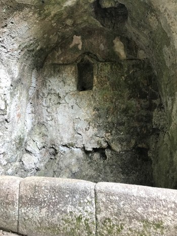
The well of Junia Rufinia, inside the Lion Gate, takes its name from the 2nd century AD Greek inscription on the parapet reciting ΙΟΥΝΙΑ ΡΟΥΦΕΙΝΑ ΝΥΜΦΩΝ ΦΙΛΗ (Iunia Rufinia, friend of the Nymphs). It was discovered by Ugolini during his first campaign in Butrint between 1928 and 1932. It was then excavated and studied again by the Butrint Foundation in 2006 and 2007.
The steam of water pouring from the natural cave, now located at the bottom of the well, probably already had a role during the first phases of the acropolis settlement. The first arrangement of the well could be dated during the construction of the wall circuit and the Lion Gate in the Hellenistic age, however it was only in the 2nd century AD that it was properly monumentalised with the construction of the vault and the laying of the inscription. It seems that it was kept in use until the 6th century AD, in accordance with the events of the rest of the city.
The whole structure was divided by Ugolini into two separate blocks, generically called "eastern room", where the well is, and "western room". The former has a pavement made of big stone blocks, while the latter's is made of mortar.
In the eastern part, the northern side, where the inscription can be found, is formed by rectangular blocks going down to the bottom of the well. An imposing structure was built right against the well during Late Antiquity. Excavations of the Butrint Foundation could not detect its function because it was only partially explored, however it probably held an important role in the city because of its location and conservation state. According to the studies of the Butrint Foundation, it was probably a small cult place built between the 5th and 6th century AD and linked to the growth of Christianity in the city. The southern side shows a rectangular niche, with two clay tiles forming a gable roof, inside which was a fresco depictions two dark blue and red peacocks and a dark brown kantharos in the middle, added in the same period of the above mentioned structure. The vault was decorated, in fact Ugolini could see the bust of a female figure surrounded by branches, however today it is not visible anymore. There is also a circular opening on the roof, a secondary well with four low walls built when the "Medieval wall", destroyed by Ugolini because it obstructed the opening arch and the reading of the inscription, prevented the access to what he believed was the Roman structure. The eastern side is characterised by a rectangular niche, semicircular on its upper side, whose painted decorations were reported by Ugolini but are not visible anymore.
For what concern the western side of the complex, its access was either through a door on its north or west wall, not visible anymore. A flight of stairs flanked by a waterhole connected it to the eastern room. As the former, it was decorated with frescos, however only the red lines forming the frames are visible today, both on the southern and western wall. This part of the complex is difficult to read because it was much more involved in renovation processes during the Medieval Age, which widely changed its appearance.
The area was barely frequented from the end of the 6th century up to the 9th century. A little cemetery was assembled here starting from the 10th century AD: the burials were divided by low, rudimental walls, made only of bricks, stones and earth. It seems that a church was built here, including the well, during the 11th century. Strictly linked to its presence are the seven burials dated between the 11th and the 14th century. The church was renovated between the 14th and the 16th century and later abandoned during the 17th century, when the wall destroyed by Ugolini and the second smaller well were built.
Bibliography on the subject
•Bowden W., Mitchell J., "The Christian topography of Butrint" in Hodges, Bowden and Lako, Byzantine Butrint: excavations and surveys 1994-99, Oxford, 2004, pp. 104-125
• Hernandez D. R., "The abandonment of Butrint. From Venetian enclave to Ottoman backwater" in Hesperia, vol. 88, 2019, pp. 365-419
• Sebastiani A., "Butrinto. Relazione preliminare dello scavo presso il Pozzo di Iunia Rufina" in Archeologia Medievale, vol. XXXV, 2008, pp. 243-261
* Sebastiani A. et al., “The medieval church and cemetery at the Well of Junia Rufina” in Hansen, Hodges, Butrint 4. The archaeology and history of an Ionian town, Oxbow Books, 2013, pp. 215-244
• Ugolini L. M., Butrinto. Il mito di Enea. Gli scavi, Istituto grafico tiberino, 1937, pp. 151-152
• Ugolini L. M., L‘acropoli di Butrinto, Roma, 1942, pp. 69-75
Wall Circuit and Gates
Leggi dettagli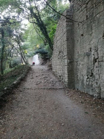
The fortifications of Butrint are one the most prominent vestiges of the ancient city. The wall circuit has been studied by numerous scholars over time, not only because its state of conservation and its stratification makes it fundamental for understanding the history of the site, but also for the value they have as part of the more general history of Epirus.
Since 2017 the Butrint Project has been involved in the topographic and photogrammetric survey of the entire wall circuit through the use of the Laser Scanning technique in order to better detect its state of conservation and deterioration, as well as locate all the different phases of its construction.
Vrina Plain
Leggi dettagli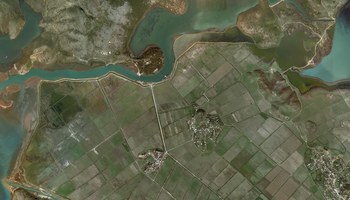
The alluvial Vrina Plain lies opposite of Butrint on the south side of the Vivari Channel. The plan was once part of a large coastal bay o the Ionian Sea. Around 3000 BC, the bay split up with alluvial material brought down by the Pavllas and Bistriza rivers. This created marsh areas along with small islands separated by small channels. From 500 BC, the growth of large deltas towards Butrint made this layout even more pronounced. By the creation of the Roman settlement, there was a number of topographical highpoint along with drained alluvial soils crossed by channels. These areas were soon used for the new suburbs.
When Ugolini first arrived in Butrint, he described the plain as marshy and wooded. He could locate some Roman ruins, however he did not recorded them in a more detailed way. The plain as it is visible today is the result of the interventions made during 1960s and 1970s as part of the program of renovation of the area of Lake Butrint. It was in this occasion that both the Bistriza and Pavla rivers were diverted from the lake to the Ionian Sea and the Butrint Bay, respectively. From 1995, the Butrint Foundation has conducted numerous field surveys and excavation on the Vrina Plain bringing to light the remains of the Roman settlement.