Water main
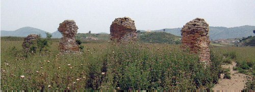
The aqueduct was first attested by Ugolini, who discovered two of its piers in the Vrina plain, and then studied by Budina. It is hardly visible today because it is in a poor state, however, it must have been one of the most striking monuments of the city. Based on its alignment and the spacing of its supporting piers (38 in total, 4.5 m from each others), it seems that the water source was in the Xarra hills, probably near Çuka e Ajtoit. The water main crossed the Vrina plain and went above the Vivari channel into the south-east corner of the city. The bridge connected to it was probably the terminus of a road through the Pavllas Valley that linked Butrint to the road connecting Aulon to Nikopolis. The best preserved part is between the hills of Shën Dëllia and Dhiministri.
The aqueduct was built during the Augustan period, it could have been an imperial benefaction. It probably continued to function until the later 4th or 5th century AD, when the associated baths in the city were abandoned. The canal was 1.20 m high x 1.05 m wide, similar to those known from the largest Roman cities. It must have had not only an important value for the city, since it allowed the use of baths and fountains as in bigger centres, but also a substantial visual and symbolic impact. The piers of the aqueduct, in fact, often appear on Butrint coinage. It seems, however, that it began to show structural weaknesses right after its completion: the southern arcade on the side of the Channel had been built on a marshy ground, which led to stability problems. Repair interventions can be seen quite often on the structure.
The piers were identified during the geophysical survey of the Anglo-Albanian Archaeological Mission in 1998. On the same occasion, a sterile area was also found on either side of the aqueduct, which probably was left free by Roman municipal laws in order to allow easy access for cleaning and maintenance work. The arcades were originally more than 5 m tall, they followed the alignment of the main road and terminated at a tank set on a gravel back at the edge of the Channel. The waters of the aqueduct were collected in a cistern or tank south of the Vivari Channel, in several bath houses all over the city, and in a large cistern in front of the Tower Gate, near the nymphaeum, which served as public fountain and place of distribution of water inside the city, as well as landmark entrance to the city.
During the Neronian age the aqueduct was extended with a new arcade crossing the entrance of the Tower Gate and following the defensive circuit in order to supply the highest part of the city too.
Image from the website of the Butrint Condition Survey
Bibliography on the subject
- Bowden W., Hodges R., Lako K., "The Anglo-Albanian Project at Butrint / Rezultate të projektit anglo-shqiptar në Butrint" in Iliria, vol. 28, 1998, pp. 275-321
- Budina D., "Harta arkeologjike e Bregdetit Jon dhe e pellgut të Delvinës / La carte archéologique de la côte ionienne et du Bassin de Delvine" in Iliria, vol. 1, 1971, p. 327, n. 60
- Çondi D., "Ujësjellësi i Butrintit / The Butrint Aqueduct" in Iliria, vol. 29, 1999, pp. 211-222
- Hansen I. L., Butrinti helenistik dhe romak. Hellenistic and Roman Butrint, London - Tirana, 2009
- Martin S., "The topography of Butrint" in Hodges, Bowden and Lako, Byzantine Butrint: excavations and surveys 1994-99, Oxford, 2004, pp. 76-103
- Wilson A., "The aqueduct of Butrint" in Hansen, Hodges, Leppard, Butrint 4. Archaeology and history of a Ionian Town, Oxford, 2013, pp. 77-96