Vrina Plain settlement
Roman period
During the establishment of the Roman colony, the original settlement was extended on the floodplain in front of the city, adding over 2.5 ha to its original size. Because of the hydrological conditions, the settlement on the Plain has been investigated not only through excavations, but also with geophysical remote sensing techniques. Some test trenches were opened in order to analyse specific magnetic anomalies: the Roman ground level was around 1 m below the surface and walls were found, made using limestone alternated with layers of brick and tile.
The land was divided on two grids of actus square probably between the deduction as Augustan colony and the 1st century AD. During the later 1st century AD this new settlement grew into a semi-urban area with attendant houses, baths, road system and a necropolis, even though still being a suburb of the main city, reaching the extension of 8 ha. The valley shows sign of centuriation: the two different units used (20x20 and 16x16) underlining that the centuriation program was divided into two main phases. It is in this phase that the construction of the so-called villa suburbana begun. It has not been investigated in its entirety, however the building that was part of its pars rustica was excavated and dated to the first phase of expansion on the Vrina Plain. The peak of the suburb can be dated between the 2nd century and the early 3rd century AD, when the settlement expanded with the construction of a large cistern and a series of new houses. In this same period, new rooms were added to the villa, as well as a large bathhouse. The remains follow a northwest-southeast alignment as the aqueduct, which cross the plain from a source 10 km higher up the valley running through the settlement. This is probably the original orientation of the whole colony as well, although the first phase of the settlement was later obscured by the next phases of construction. The south-western edge of the settlement seems to have been bounded by a no longer visible channel. It also seems that there was a canal running parallel to the aqueduct.
The excavation of the Anglo-Albanian Team brought to light a rectangular building, first discovered in 1980s, belonging to the expansion of the 1st century AD. It had been interpreted as a cistern because of its proximity to the aqueduct and the presence of a thick mortar surface on both the floor and the walls. Later, the excavations in 2004 and 2005 interpreted it as a small temple, built at the end of the 2nd century AD. The analysis of Gilkes et al. (2013), based on the presence of tombs and sarcophagi near the structure, has led to the final interpretation that the building was a mausoleum, a type of structure well documented in the western Mediterranean in the 2nd and 3rd century AD. It was probably an important structure in the Vrina plain: it was elevated on an artificial podium, built in opus caementicium. The building had a cella, whose southern wall and internal arrangement are still visible, even though it was damaged and robbed over time. It was built using opus listatum with triangular cut brick set into mortared rubble core, the floor was of cocciopesto mortar, and there seems to have been veneered stone and marble on the walls. The axial entrance forms a pronaos, whose stone paving slabs are still partially visible. The antes were constructed in opus caementicium, faced with stone slabs, projecting on the steps. The lowest step survives in place, while the others have been robbed, however it has been estimated that there were at least 7 other steps above the one left. It can be considered the first Italic style building found in Albania. There were other structures around the temple, probably commemorative column or altars. A church was later built on the west wing in Late-Antiquity. A road lead east to west through the settlement connecting houses, baths, other buildings arriving finally at the temple on its northern side. Probably the road continued under the aqueduct and through the necropolis. The construction of the mausoleum was contemporary with the construction of a wine press in the villa and the slow fallen into disuse of the complex.
Late Antique and Medieval period
During the 3rd century AD the number of private buildings along the shores of the Vrina Plain increased, in fact geophysics surveys have detected numerous structures that could be interpreted as houses or villas. All these domestic complexes are interpreted as elite residences, large houses with reception rooms, courtyards, and baths, the latter in particular was quite popular in Butrint, in fact five such structures were identified only on the Vrina Plain. An example is the large late-Roman domus in the southwest part of the city plan covering several insulae, as well as traces of the orthogonal street grid and several structures near it. The most relevant part of the building is the peristyle court with an ornamental pool, constructed as a double basin of pools set one within the other. The porticos open on the courtyard had mosaic pavements slightly above the level of the court. There were two entrances, both leading to the northern colonnade, and the most prestigious was the one on the side of the Channel. This means that visitors could see the open court with the pool on one side while entering the building, while on the other a wide, rectangular room, terminating in an apse, were they were probably received by the owner of the house. There were thermal baths near both entrances. From the eastern portico of the peristyle, rooms reserved for dining were accessible. The house was probably occupied until the middle/late 4th century AD and later abandoned as consequence of an earthquake.
The domus was occupied again at the beginning of the 5th century. The apsidal hall was repaired and two new buttresses were built to support the new building. However, soon after the water level began to rise, the aqueduct collapsed, and the complex was abandoned again. The building of a Paleochristian Basilica in the late 5th century seemed to give new life to this suburb. This new basilica was built over the southern wall of the apsidal hall and partially covered the northern peristyle and courtyard of the earlier domus. New building were constructed, however some rooms of the domus were still in use, both as dwellings, for official purposes, and for accommodating visitors. The dwellings on the Vrina Plain were abandoned between the 7th and 8 century AD.
It was only between the 9th and the 10th century AD that the site was occupied again as residence of the Byzantine official. It was surely the centre of administration, but it could also have had a manufactural role: numerous kilns were built in earlier structures. This occupation did not last long because the environmental conditions were too unstable. From the 12th century onwards, only small scale seasonal activities were conducted on site, even though the presence of religious building must have preserved its importance. Various burials were found within the ruins. The emergence of wetlands and swamps led to the abandonment of the area until the interventions began in 1960s.
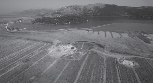
Image depicting the excavation of the Butrint Foundation on the Vrina Plain from Greenslade S., "The Vrina Plain settlement between the 1st-13th centuries" in Hansen and Hodges, Butrint 4. The archaeology and history of an Ionian town, Oxbow Book, 2013, pp. 123-164
Bibliography on the subject
- Bescoby D. J., "Geoarchaeological Investigation at Roman Butrint" in Hansen I.L., Hodges R., Roman Butrint. An assessment, Oxbow Books for the Butrint Foundation, 2007, pp. 95-118
- Bescoby D. J., Cawley G. C., Chroston P. N., "Enhanced Interpretation of Magnetic Survey Data using Artificial Neural Networks: a Case Study from Butrint, Southern Albania", in Archaeological Prospection, vol. 11, 2004, pp. 189-199
- Bowden W., Hodges R., Lako K., "The Anglo-Albanian Project at Butrint / Rezultate të projektit anglo-shqiptar në Butrint" in Iliria, vol. 28, 1998, pp. 275-321
- Bowden W., Hodges R., Lako K., "Roman and late-antique Butrint: excavations and survey 2000-2001" in Journal of Roman Archaeology, vol. 15, 2002, pp. 199-229
- Chroston N., Hounslow M., "The geophysical survey: the extent and structural layout of the suburbs of Butrint on the Vrina Plain" in Hodges, Bowden and Lako, Byzantine Butrint: excavations and surveys 1994-99, Oxford, 2004, pp. 64-75
- Crowson A., Gilkes O. J., "The Archaeology of the Vrina Plain: An Assessment", Hansen I.L., Hodges R., Roman Butrint. An assessment, Oxbow Books for the Butrint Foundation, 2007, pp. 119-164
- Gilkes O. and Çondi D., "An Italic Style Temple from the Vrina Plain, Butrint / Tempulli në Fushën e Vrinës, Butrint" in Iliria, vol. 32, 2005, pp. 155-170
- Gilkes et al., "The Eastern Villa Suburbana and Its Pars Rustica on the Vrina Plain" in Hernandez D.R and Hodges R., Butrint 7. Beyond Butrint. Kalivo, Mursi, Çuka e Ajtoit, Diaporit and the Vrina Plain. Surveys and excavations in the Pavllas River Valley, Albania, 1928-2015, Oxbow Books, 2020, pp. 155-182
-
Greenslade S. et al., Butrint 6: excavations on the Vrina Plain, Vol. 1-3, Oxbow Books, 2019
- Greenslade S., "The Vrina Plain settlement between the 1st-13th centuries" in Hansen and Hodges, Butrint 4. The archaeology and history of an Ionian town, Oxbow Book, 2013, pp. 123-164
-
Greenslade S., Çhondi D., "Recent excavations on the Vrina Plain, Butrint: a preliminary report on the archaeological sequence from 1st to 6th century" in Lamboley, Castiglioni (a c.), L’Illyrie méridionale et l’Epire dans l’Antiquité V. Actes du Ve colloque International de Grenoble (10-12 Octobre 2008), 2 volumi, De Boccard, 2010, pp. 265-277
- Hansen I. L., Butrinti helenistik dhe romak. Hellenistic and Roman Butrint, London - Tirana, 2009
- Hansen I. L., "Between Atticus and Aeneas: the making of a colonial elite at Roman Butrint" in Sweetman, Roman Colonies in the First Century of their Foundation, Oxbow Books, 2011, pp. 85-100
- Hernandez D. R., "Battling water: the frontiers of archaeological excavation at Butrint (1928-2014)", in The Annual of the British School at Athens, 2017, pp. 1-34
- Hernandez D. R. and Hodges R., Butrint 7. Beyond Butrint: Kalivo, Mursi, Çuka e Aitoit, Diaporit and the Vrina Plain. Surveys and Excavations in the Pavllas River Valley, Albania, 1928-2015, Oxbow Books, 2020
- Hodges R., Carr E., Sebastiani A. and Vaccaro E., "Beyond Butrint: The ‘Mursi Survey’, 2008." in The Annual of the British School at Athens, 2016, pp. 1-29
- Martin S., "The topography of Butrint" in Hodges, Bowden and Lako, Byzantine Butrint: excavations and surveys 1994-99, Oxford, 2004, pp. 76-103
- Mustilli D., "Relazione preliminare sugli scavi archeologici in Albania (1937-1940)", in Reale Accademia d'Italia. Rendiconti della classe di scienze morali e storiche, f. 12, series VII, vol. II, Roma, 1941, pp. 703-704
- Ricciardi R., "Two Roman monuments: proposals for function and context" in Hansen I.L., Hodges R., Roman Butrint. An assessment, Oxbow Books for the Butrint Foundation, 2007, pp. 165-174
- Ugolini L. M., L‘acropoli di Butrinto, Roma, 1942, pp. 76-80