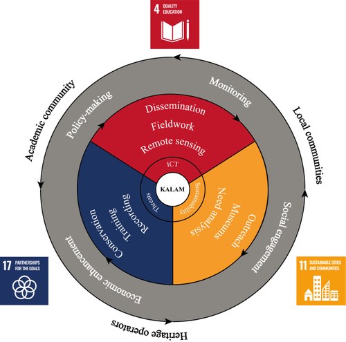
KALAM aims at proposing effective methods and protocols for the analysis, protection and development of archaeological landscapes in Iraq and Uzbekistan, two countries which have not yet collaborated in the field of cultural heritage. However, this approach is conceived to be potentially applicable to any other endangered cultural landscape.
The concept of “lived-in landscapes”, where inhabitants constantly interact with culturally-rich landscapes endlessly changing for multiple anthropic reasons (broadly defined as stemming from agricultural and infrastructural activities), urges the creation and application of adequate theories and methodologies to understand such changes through time. This idea of landscape as the result of an interaction of natural and human factors can be found in the 1992 ratification of Art. 1 of the UNESCO World Heritage Convention (1972), where cultural landscapes are illustrative of the development of human society and settlement over time, under the influence of environmental constraints and of successive social, economic and cultural forces, both external and internal.
Task 1. Consequences in the use of ICTs in relation to cultural heritage
Based on the solid, years-long experience of archaeological research in Western Asia shared by the KALAM consortium, the partners plan to evaluate the limitations of standard fieldwork and the needed methodological improvements. Starting from the datasets collected through several regional field projects in central, southern Iraq, and in the Middle Zeravshan Valley in Uzbekistan, where some 4000+ surveyed and remote-sensed sites and 2000+ were respectively mapped (Samark-Land Project). The extreme density and variety in date of sites, whose remains are however often most fragile (such as mudbrick architecture) and little visible, are indicative of the informative potential of these areas. For these reasons, the KALAM partners plan to further expand these large datasets through traditional methods (from field surveying to multitemporal and multisensor remote sensing analysis) supplemented by an innovative application over the investigated areas through AI software for an automatic detection of archaeological “objects'' on large swaths of land. This process relies on constant, cyclical instructions feeding and machine learning with acquired data from known sites and known non-sites vs. similar, though false, patterns for calibrating the routine, thus positively speeding-up a time-consuming procedure and improving the accuracy in terms of quantity and quality of collected data. This routine will include a remote AI-driven analysis of already surveyed areas, following a principle of data validation and augmentation. This will be followed by a preliminary assessment performed on selected un-surveyed landscapes, thus providing new data to be then ground-truthed. These activities will lead to the drafting of multiscale “risk maps”, where critical issues on historical heritage will be highlighted and detailed.
Task 2. Threats to heritage
Aside of the reconnaissance and validation of archaeological land patterns at every scale, the remote AI-driven analysis delves also on the processes affecting the investigated landscapes. In fact, the critical assessment of the multiple threats and damages of the cultural heritage can be considered backbone of KALAM project. This second step includes thus a critical assessment of the looming threats and damages to archaeological landscapes. This activity will be integrated by training workshops addressed to heritage operators, such as officials of national and local authorities, NGOs / CSOs and community leaders at large. Following these training sessions, pilot programs in conservation will be performed at selected sites in Iraq and Uzbekistan, engaging all KALAM partners in public archaeology at regional level.
Task 3. Contributions of cultural heritage to an economically and socially sustainable future
The activities performed in the aforementioned stages will be supported by a strategy for enhancement and community engagement, coordinated by a multi-disciplinary team of archaeologists, geographers and anthropologists. This task will be performed through multiple steps:

The KALAM project addresses several urgent issues which are included within the framework of the Sustainable Development Goals (SDGs), in line with the mission of University of Bologna since 2016.