

UZBEKISTAN - KAFIR KALA
Within the framework of our Task 3 “Contributions of cultural heritage to an economically and socially sustainable future,” an interdisciplinary research team of 7 geographers and anthropologists from UNIBO visited – between May 17th and June 11th 2022 – the region of Samarkand in Uzbekistan and undertook a Heritage Value Assessment (Task 3.a) in the landscape around the archaeological site of Kafir Kala, in the modern villages of Naizatepa and Nayman in the Samarkand and Tailok districts. Their work, based on the community-based participatory research method, focused on the interaction with the local communities and institutions at every level, to understand their behaviour and relation with the historical landscape and heritage of Samarkand.
The KALAM team, coordinated on the field by Ass.Prof. Roberta Bonetti, Ass.Prof. Andrea Zinzani and Dr. Licia Proserpio with the support of Ass.Prof. Simone Mantellini, relied on applied research and adopts social-environmental research methods, such as interviews, focus groups, participatory immersion and ethnography. The primary aim was to initiate a process of direct involvement of the local community living the Kafir Kala archaeological landscape, starting from the available community-level main institutions, such as villages local administrations (mahalla) and schools. The interaction with civil society, from adults to youth, led to the recording of local knowledge, values, narratives and legends connected to the tangible archaeological landscape heritage.
With this spirit, around 30 interviews were conducted among local, national and international institutions, farmers, shepherds, children, workers, archaeologists, PhD students, teachers and pupils and community leaders of the targeted villages. This work allowed to understand the common familiarity of the local inhabitants with the ancient site and its related features, such as irrigation canals.
Finally, the collaboration with local and international institutions operating in the region, such as the Samarkand Institute of Archaeology, the Ministry of Tourism and Cultural Heritage of Uzbekistan and UNESCO IICAS, led to strengthened relations between them and to a raised interest for the formalisation of policies about the creation of the Kafir Kala Archaeological Park (included within Task 3.b), starting from the definition of the core and buffer areas in and around the site.
The activities completed in 2022 and 2023 allowed to reach significative milestones in the construction of a mutual connection and cultural exchange with the local community of Nayman. Finally, in April 2024, Ass.Prof. Bonetti organised multiple meetings with the teachers, students and parents, and visits of the School 1 of Nayman, enhancing new perspectives on intergenerational dialogue and allowing for the further documentation of certain rituals and the collection of valuable variants of narratives around the archaeological site, preserved in the community's collective memory. The activities involved several classes belonging to different age groups, engaging a total of ca. 500 students, and featured debates, specific history and geography lessons on Kafir Kala, the sharing of familiar traditional objects within the classrooms, and visits to the site during ongoing archaeological excavations. This resulted in further reinforcing the sense of ownership by the students, as emerged during conversations and interviews, including those with elderly people organised in the private homes of some of the teachers.
The records and experiences collected during the three-year research activities were collected into the didactic publication "Kafir Kala. Digging in the Past, Building the Future: A Participatory Experience between Schools and Communities" addressing teachers and students, and framed to be a bridge between cultures and generations. The volume, drafted in three languages (Uzbek, English, Italian) and enriched by an introduction by Vinicio Ongini, the current contact person for interculturalism for the Italian Ministry of Education and Merit, has a dual purpose: while restoring the value of the shared experience into the local Uzbek community, it also represents a valuable tool to make the reality of Kafir Kala closer to Italian schools. In fact, starting from the 2026 school year, a series of online meetings are planned to facilitate an intercultural dialogue between Italian students and their Uzbek counterparts at Nayman School 1, creating new opportunities for exchange and mutual learning.
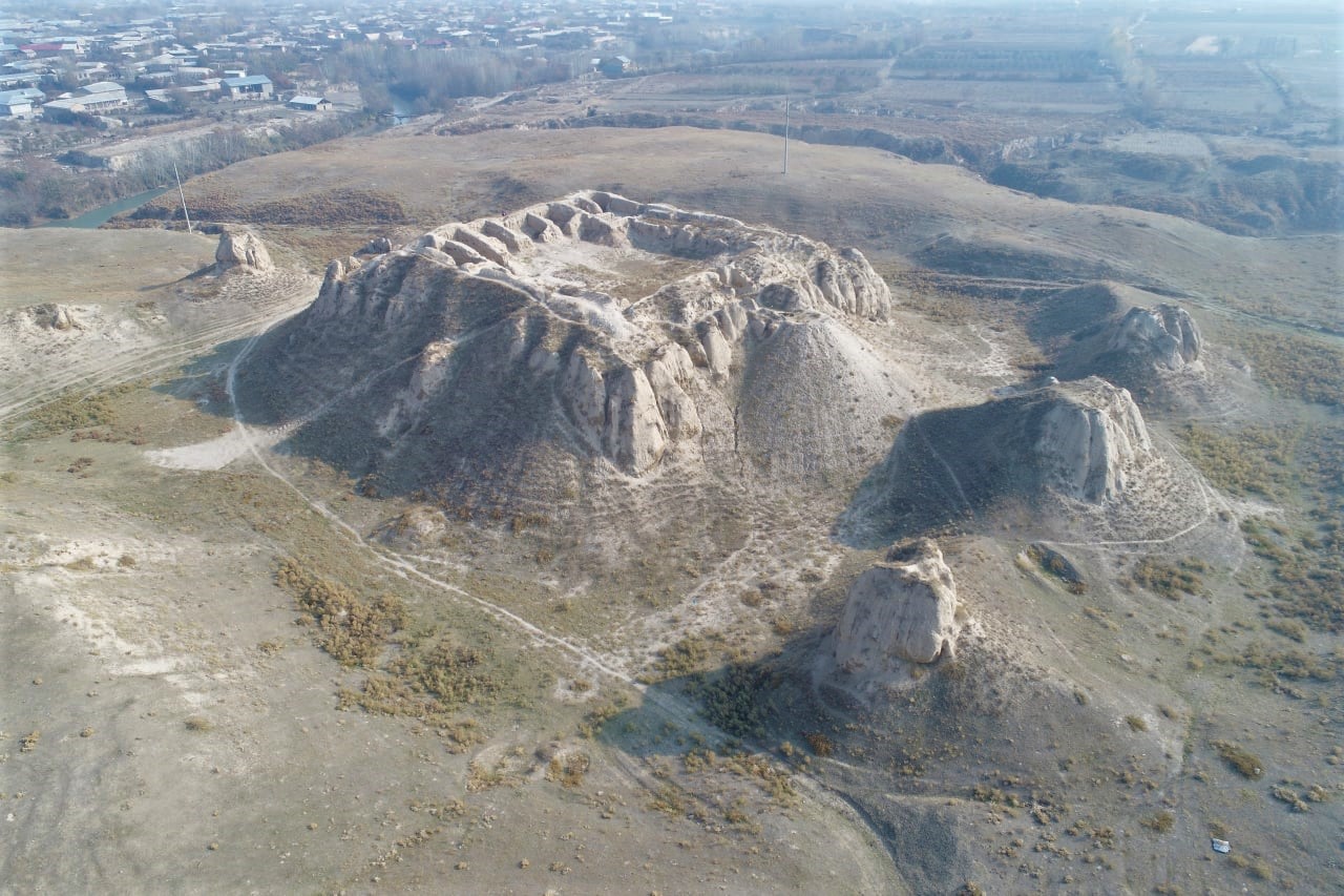
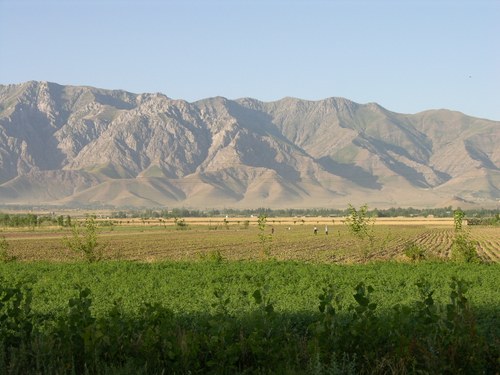
Fig. 1. With its massive citadel dominating the surrounding contryside, the archaeological complex of Kafir Kala is one of the largest and most important sites in the Samarkand Oasis and along the "Silk Road".
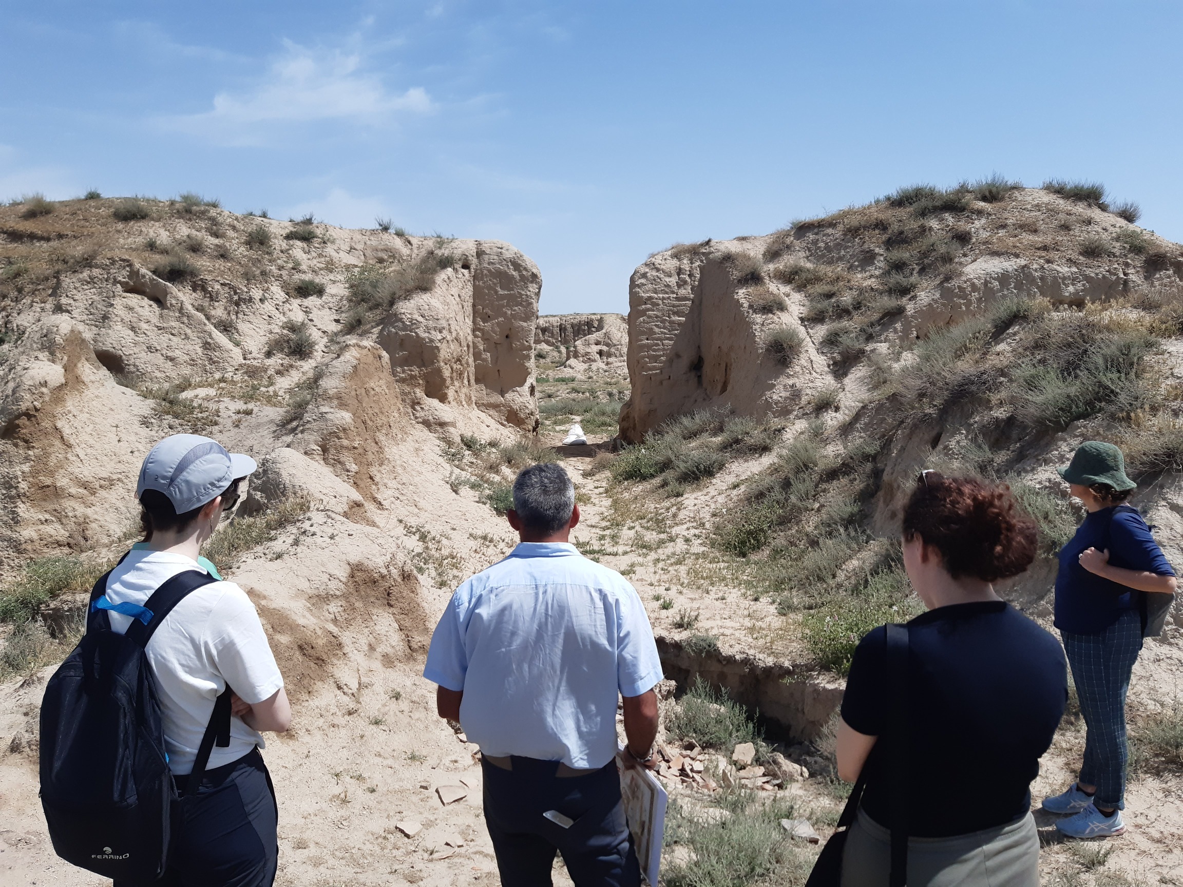
Fig. 2. An interdisciplinary research team of archaeologists, conservators, geographers and anthropologists worked on the site and in the surrounding countryside.
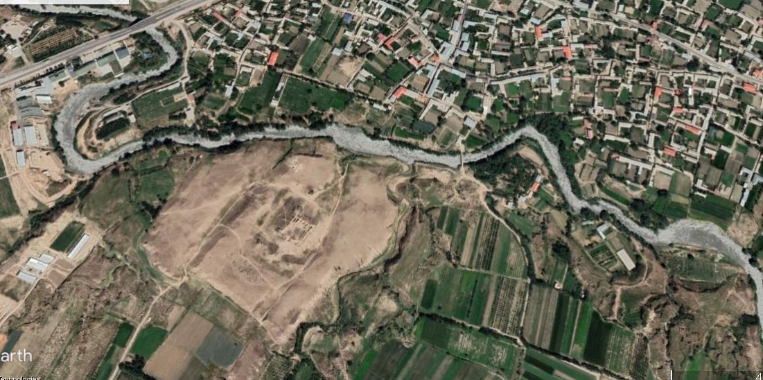
Fig. 3. The archaeological landscape of Kafir Kala includes a network of small and large modern communities which live in direct, constant contact with the ancient site.

Fig. 4. Working at Kafir Kala means interacting with multiple, different actors who have been in constant contact with the site and its historical landscape for centuries.

Fig. 5. Based on the fieldwork performed within the communities around Kafir Kala, the KALAM team have tried to define the multiple actors involved, in order to better frame outcomes and recipients of the results.
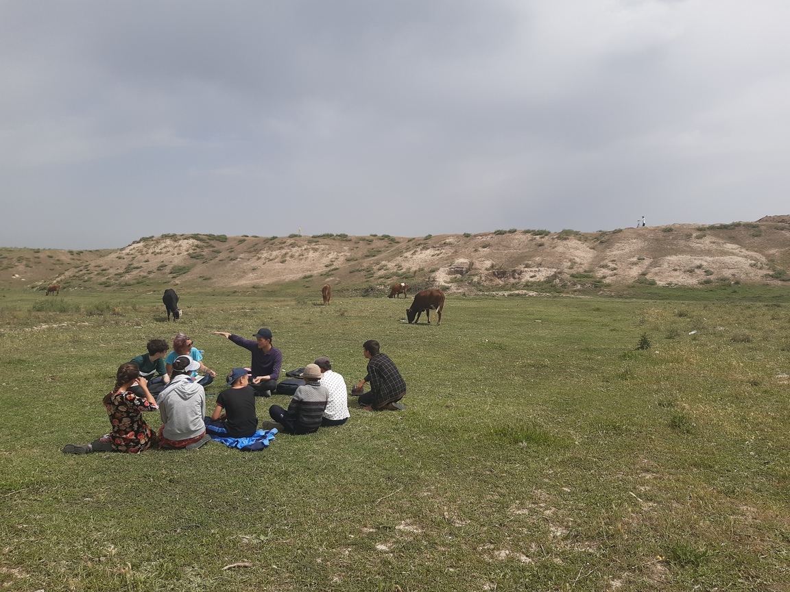
Fig. 6. The archaeological area of Kafir Kala features the regular presence of farmers and shepherds with their herds, together with occasional visits of teachers and students from the local schools.
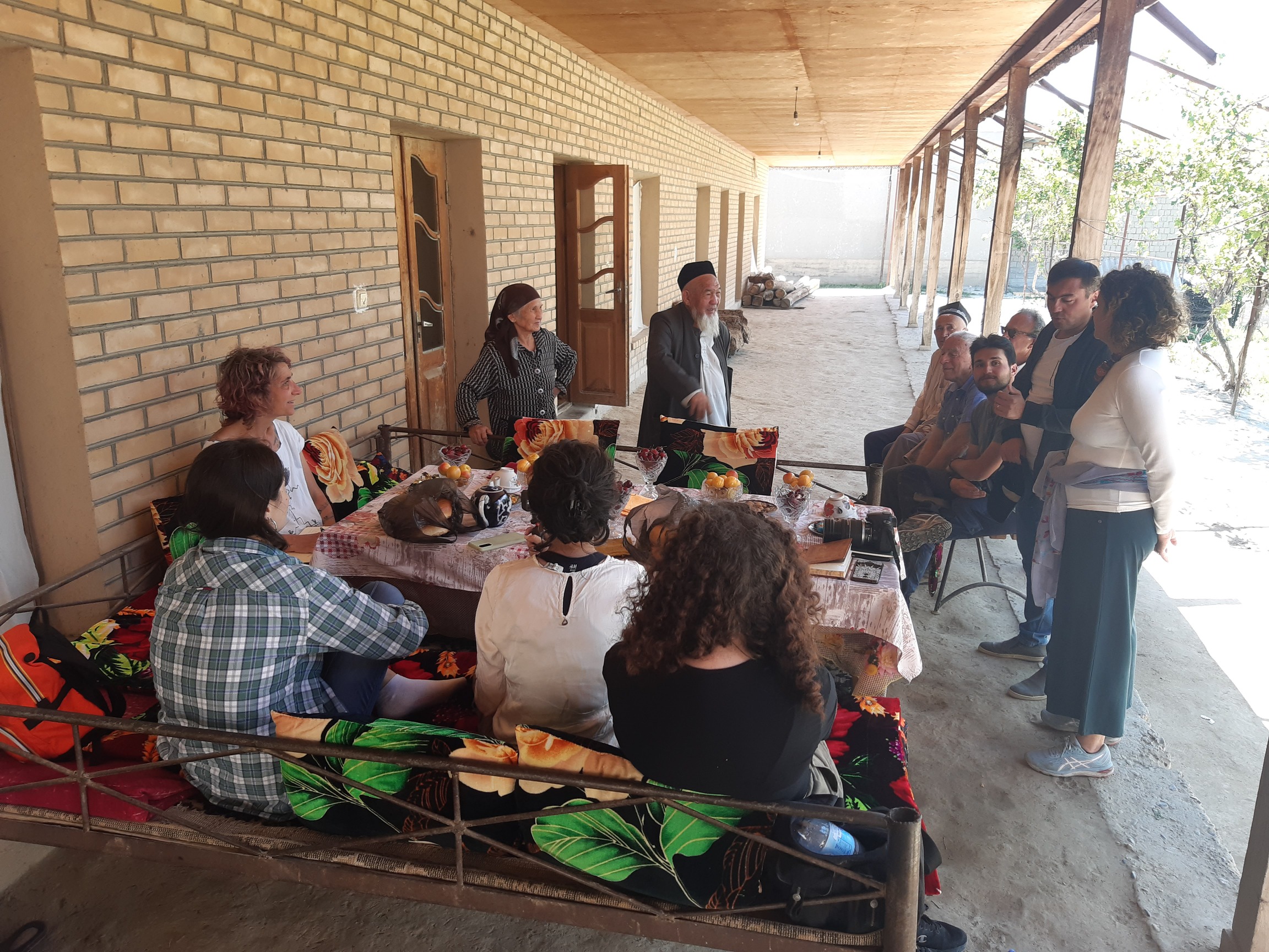
Fig. 7. The KALAM team performed around 30 interviews among different actors related to the site, from the local, national and international institutions to the community leaders in the area, allowing to define and understand their level of interaction with the ancient landscape.
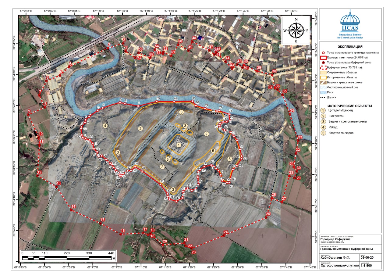
Fig. 8. The cooperation with the national and international institutions has been instrumental to implement the KALAM tasks, for instance to define the extension of the Kafir Kala Archaeological Park (Image courtesy of IICAS, UNESCO, Samarkand).

Fig. 9. The active participation of teachers and students from Nayman School 1 provided multiple narratives on Kafir Kala and its value for the local communities
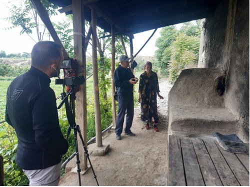
The social-ethnographic assessment performed throughout 2022 and 2023 by a team of 3 geographers under the coordination of Ass.Prof. Zinzani was completed in 2024 (from May 10th to June 14th) through the usual combination of semi-structured and unstructured immersive ethnographic interviews, participant observation and subsequent focus groups to analyse the collected material and share impressions from the interviews with local and international institutions, and local actors such as the mahallas of Nayman and Naizatepa, and farmers and shepherds working around the archaeological area of Kafir Kala. As a result, the establishment and strengthening of personal relationships with local community leaders (rays) and members, created a positive situation which provided a much deeper knowledge of the local context and its land use, and helped cementing relationships of trust with the Nayman people. The opportunity to respectfully attend the community's moments of mourning allowed to get to know each other beyond the fieldwork dynamics as individuals, and to better frame the social interactions that bind the inhabitants of mahalla.
Furthermore, the interaction with the local inhabitants provided a deepen understanding of Kafir Kala as a living space (produced and marked by socio-ecological relations). In this sense, we were able to delve into the landscape itself from the perspective of the Nayman inhabitants who experience the area through pastoral and agricultural activities and as a place of sociability. Memories of the Soviet past (such as the landscape transformation occurred for political-economic development) and annual festive occasions (the Nawrouz, among others) represent a constant in the local storytelling. In other accounts, Kafir Kala emerges as a mysterious place, an ancient fortress, surrounded by various legends passed down in family gatherings and schools classes.
The creation of the video contents by the videomaker Danilo Ortelli (specific for dissemination purposes) allowed for a further exploration of the relationships between the inhabitants of the mahalla and the landscape of Kafir Kala.
IRAQ - NINEVEH
Within the framework of our Task 3 “Contributions of cultural heritage to an economically and socially sustainable future,” a research team including an archaeologist and an anthropologist from UOM performed in September 2022 a Heritage Value Assessment (Task 3.a) in the archaeological area of Nineveh and the modern neighbourhoods surrrounding the site. The work aimed at understanding the relation and knowledge of the Mosul communities toward the archaeological remains.
The team, coordinated by Prof. Khalid Salim Ismael, defined three main target groups based on their level of involvement with the site: the residents living around the site or in one of the illegal villages in the area of al-Rahmaniyah, the heritage operators of the local SBAH branch and the administrative staff and officials in charge of the promotion of tourism and culture at Mosul.
Around 30 interviews (10 for each group) were conducted, trying to understand the perspective of the different target groups on the matter of preservation and protection of ancient Nineveh.
IRAQ - NINEVEH
Within the framework of Task 3.b “Thematic museum halls and visitors’ centers”, a KALAM team including archaeologists and personnel from UOM and UNIBO in cooperation with SBAH defined the area within ancient Nineveh for the creation of the forthcoming Nineveh Visitors’ Center: preliminary work started in July 2022, with the selection of an archaeologically void area in the northern sector of the site. The construction of the Visitors’ Center has followed traditional Iraqi building methods, with the employ of sustainable and traditional materials (mudbricks, mud plaster, gypsum and, only for the foundation layer, stone, strictly avoiding the use of cement): the aim has been to minimize the impact on the site and the archaeological and environmental landscape, as well as designing a building aesthetically and functionally valid. The construction works continued throughout the following months, until the completion of the complex by Autumn 2023: the main building has been equipped with a welcome desk space and wooden furniture, while panels on the walls illustrate the history and archaeology of Nineveh. The access to the structure is provided by a walkway made of baked mudbricks while a front yard has been arranged with local plant species. The whole complex, completed by a double restroom for tourists' use and surrounded by a metallic fence, was then inaugurated during the opening of the Archaeological Park of Nineveh on October 24th 2023.
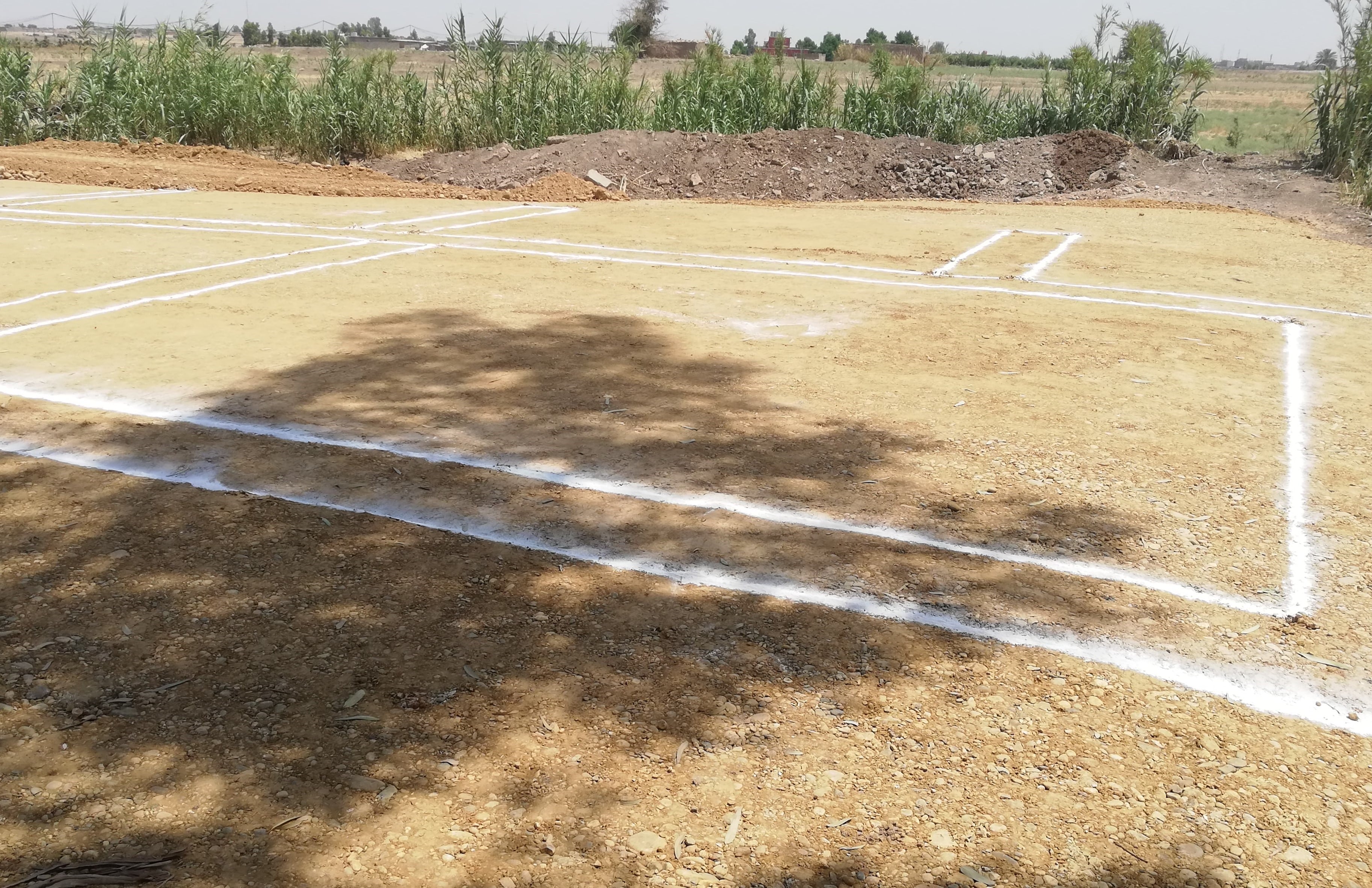
Fig. 1. The location of the Visitors' Center of Nineveh was selected to be functional to the tourist paths crossing the site and for its proximity to visible landmarks.
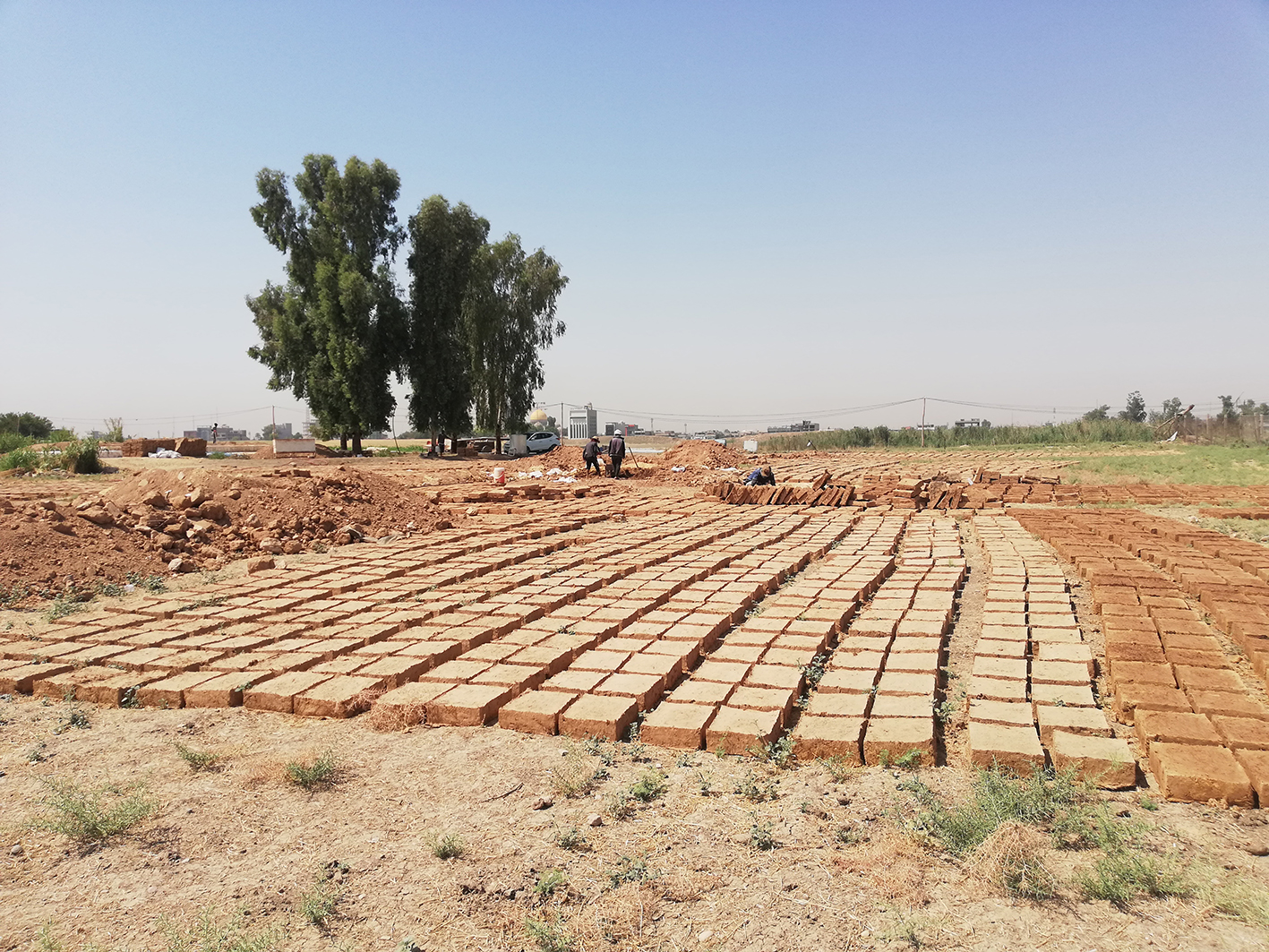
Fig. 2. Low impact and sustainability have been key elements in the planning and early realisation of the Visitors' Center.
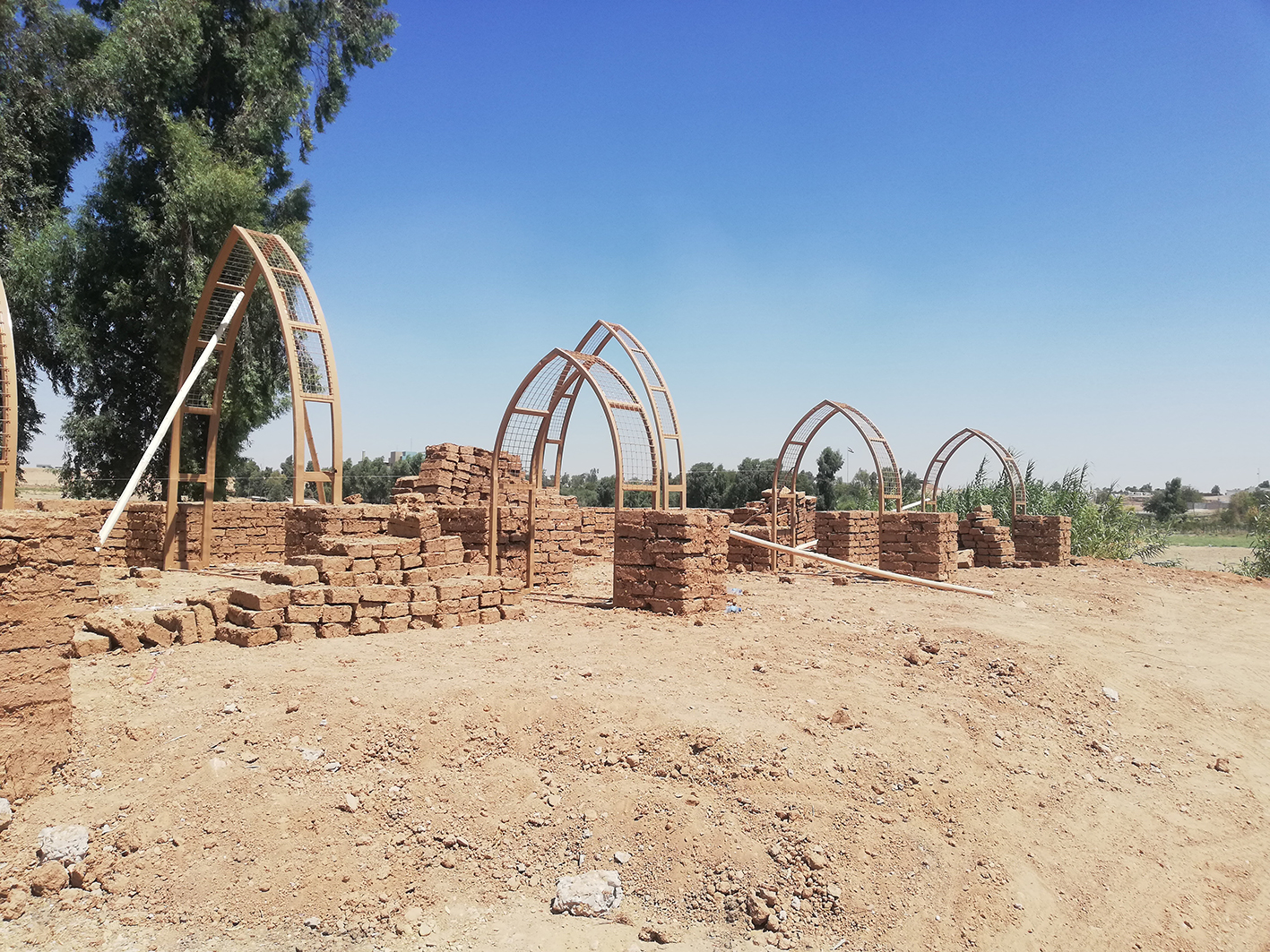
Fig. 3. The architecture of the Visitors' Center features stylistic patterns and elements (such as pointed arches) which can be found in ancient Assyrian palaces as in several buildings of Medieval and Modern Mosul.
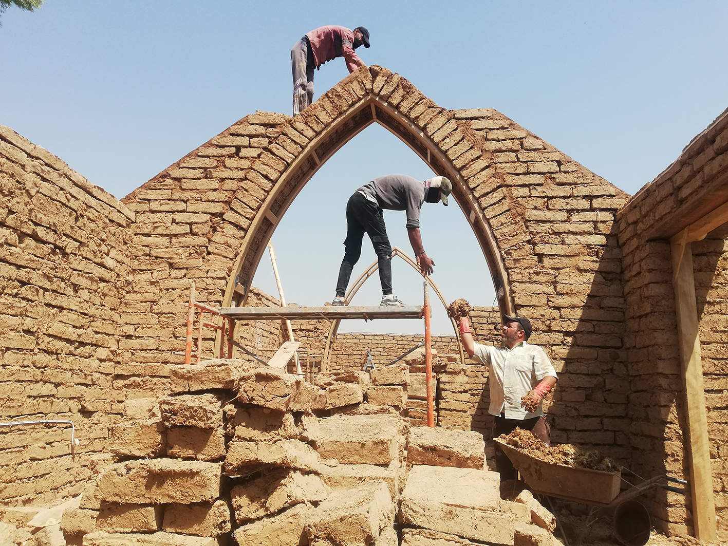
Fig. 4. Local scholars, students and workers have been included in the planning and construction phases, forstering the collaboration among the different communities around Nineveh.
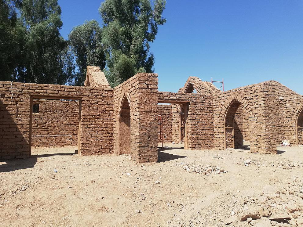
Fig. 5. Mudbrick architecture, attested since the dawn of urbanisation in ancient Mesopotamia, is still recurrent nowadays for traditional constructions all over Iraq.
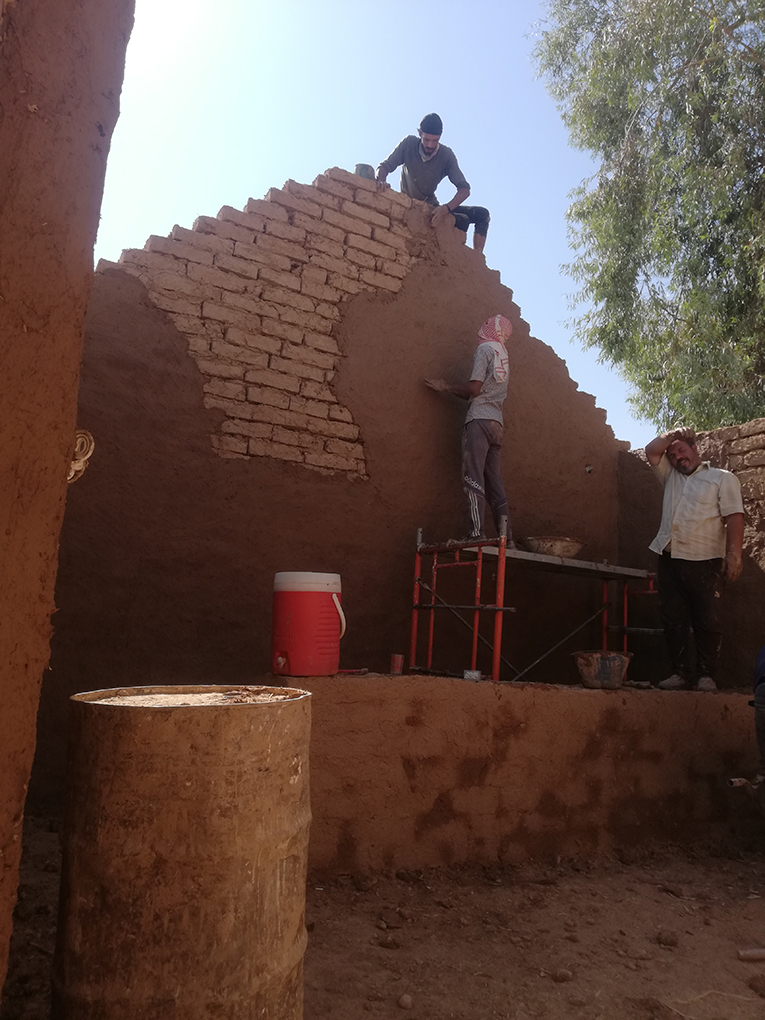
Fig. 6. To achieve a higher durability and to present an uniform appearance, the inner and outer wall surfaces have been covered with mud plaster.
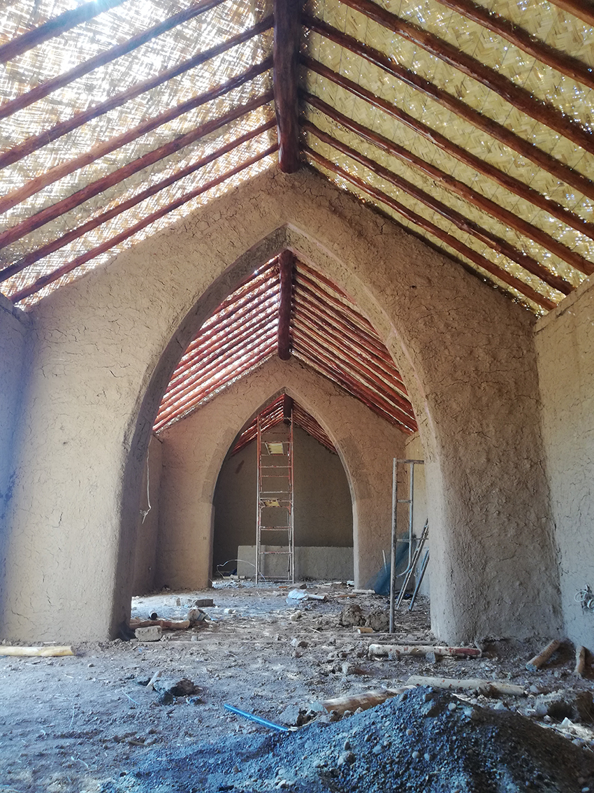
Fig. 7. The covering has been completed with wooden pools sustaining a intertwined straw roof, which has been covered with mud plaster on the outer side.
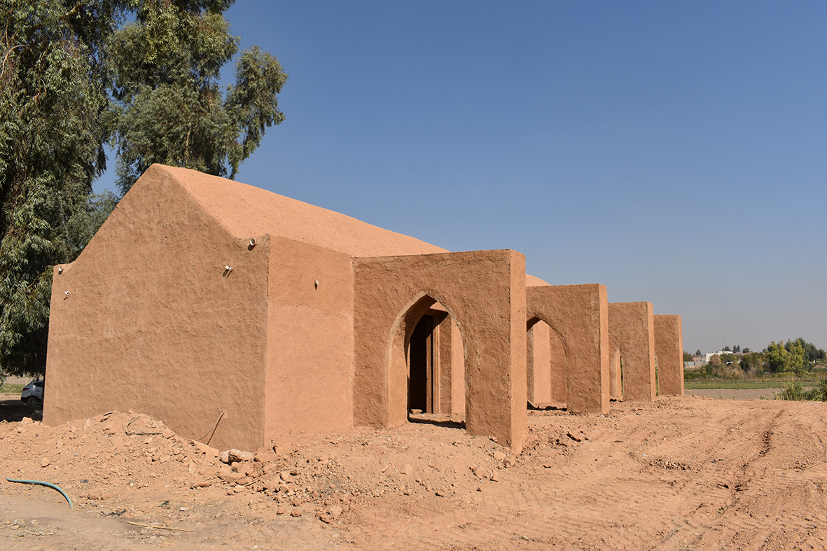
Fig. 8. The creation of the Visitors' Center represents a further reason for the recovery and improvement of the Nineveh landscape, integrating ancient and more recent structures.
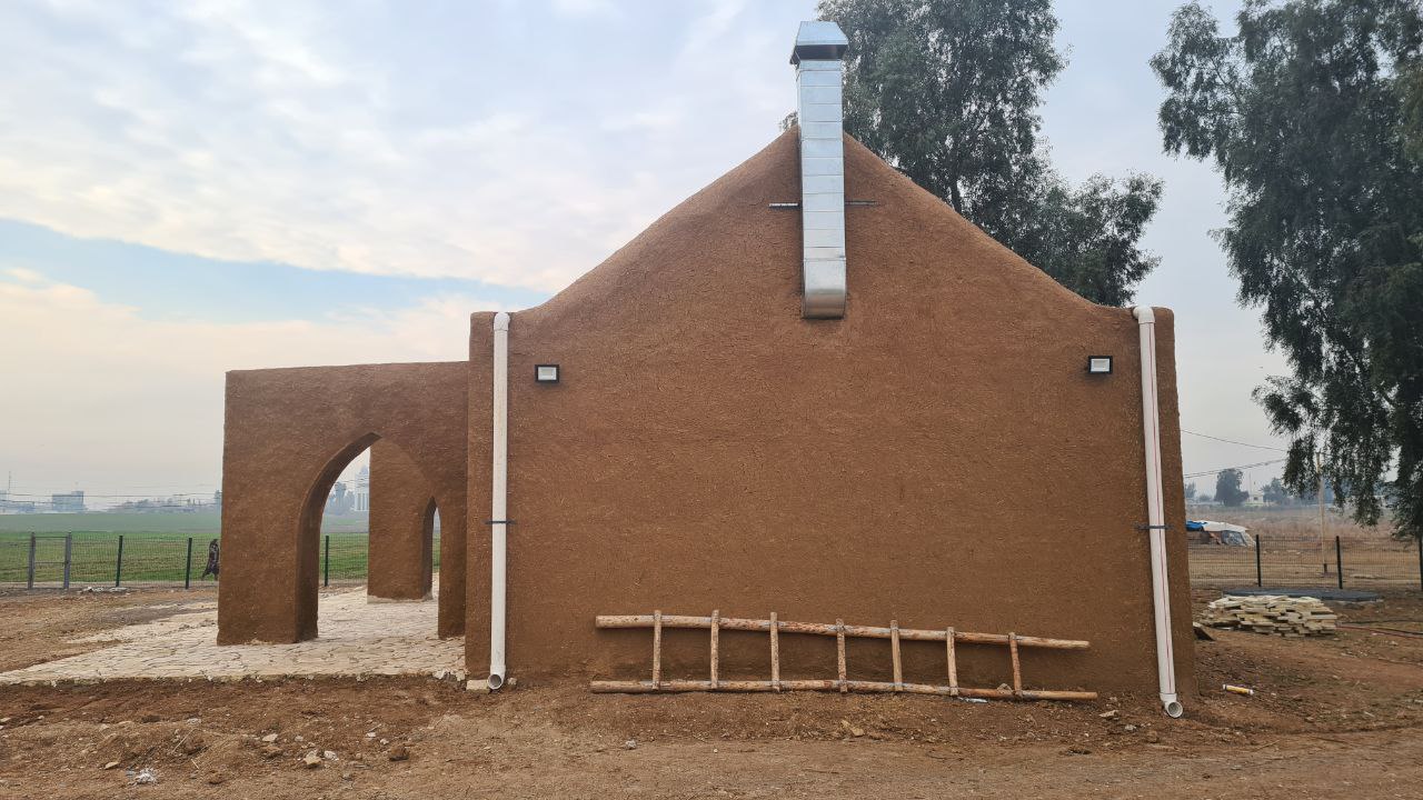
Fig. 9. Facilities (such as external lights, drainpipes, airducts) have been added to make the Visitors' Center a confortable hub for local people to gather throughout the different seasons of the year.
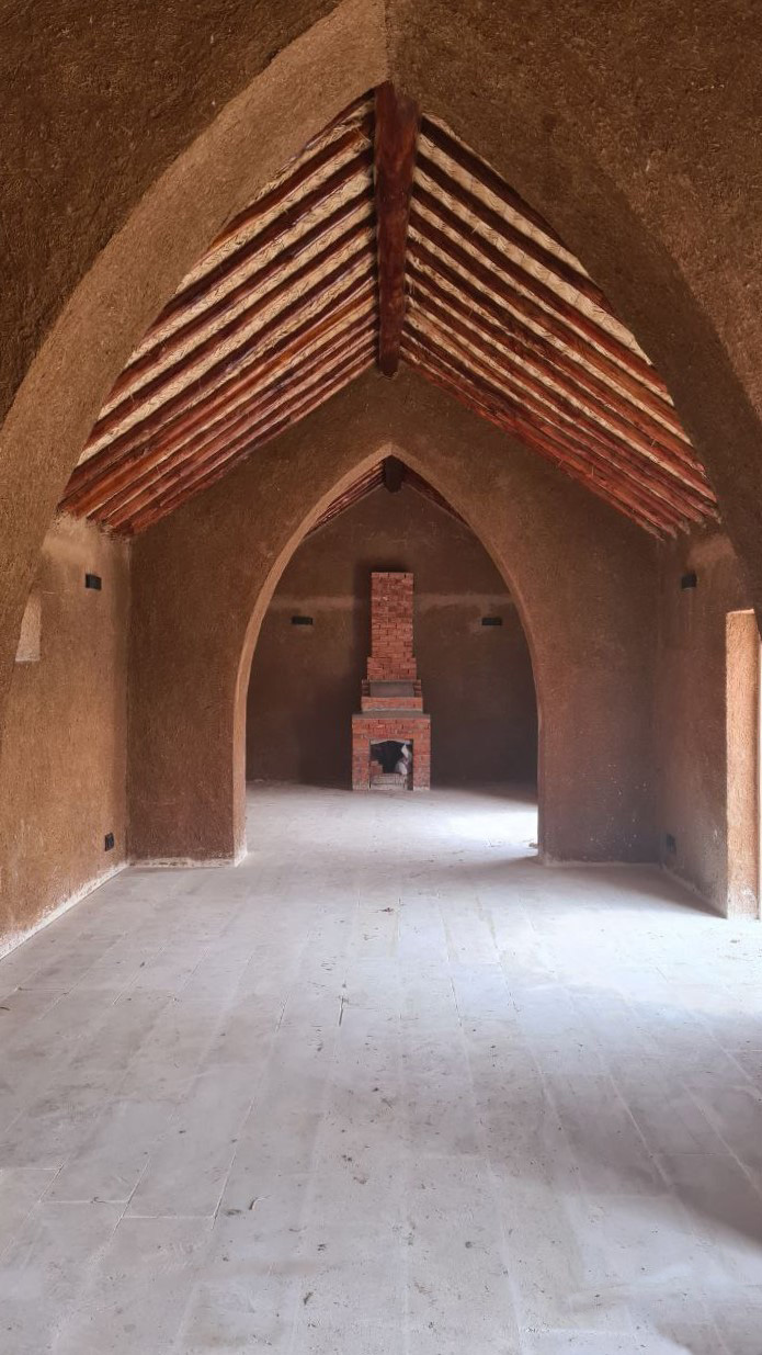
Fig. 10. The furnishing of the interior of the Visitors' Center will include all is required to make it a gathering place for both the local communities and the future groups of tourists.
UZBEKISTAN - KAFIR KALA
The field actitives occured in the Samarkand countryside between May and June 2022 also included preliminary operations for the construction of the Kafir Kala Visitors' Center. Within the framework of Task 3.b “Thematic museum halls and visitors’ centers”, non-invasive investigations were undertaken in the area at the entrance of the site, identified as suitable for its construction: the geophysical survey, done by the International Institute for Central Asian Studies (IICAS, UNESCO), did not reveal any anthropic underground evidence. The subsequent survey by the UIAP team confirmed the lack of any archaeological feature in that sector, hence making feasible the construction of touristic facilities.
A fundamental milestone among the activities completed in 2023 was the inscription of Kafir Kala in the UNESCO World Heritage List, as part of the larger Silk Roads: Zerafshan-Karakum Corridor with other historical places across Uzbekistan, Tajikistan and Turkmenistan. This event resulted in the drafting of a mandatory 'Heritage Impact Assessment', which includes the plan of the structures to be created for the archaeological park: paths and panels, a concept design of the Visitors' Center, parking lots for cars and buses, and the zonation with the specific areas left for local communities. The proposal, currently under evaluation, was submitted to ICOMOS through IICAS, UNESCO, and to the National Scientific Council of the Republic of Uzbekistan, in charge of the verification of the compliance of the project with the country's cultural heritage legislation. Following its approval, operations for the creation of the park and Visitors' Center will begin.
In 2024 the creation of the Museum Hall 'Archaeological Landscape of Samarkand Oasis' to be located in the Samarkand State Museum, has started. The designated space has been renovated, to be more functional accordingly to the expected increase of visitors, and completed in late 2025. The exhibition has been planned to include 6 thematic panels illustrating the development of the archaeological landscape of Samarkand (ancient Afrasiab) and its close relationship with water: (1) Archaeological Landscape; (2) Ancient Waterscapes; (3) Modern Waterscape; (4) Archaeological Map and Sites Threatening; (5) the four Samarkands (or the evolution of the city through time); (6) the Site of Afrasiab. Supporting the informative panels, a screen will play different visual contents produced by the videomaker Danilo Ortelli. The inauguration occurred on June 13th 2025, with the participation of local authorities, museum personnel and the members of the Uzbek-Italian Archaeological Expedition at Samarkand (UIAP).

Fig. 1. Kafir Kala, located in the Samarkand hinterland and along the historic Silk Road, represents a significative landmark for cultural and tourist purposes.

Fig. 2. The Visitors' Center at Kafir Kala will be located at the entrance of the site, where recent excavations have uncovered the presence of a necropolis (right) dating to the Middle Ages (Drone acquisition by IICAS, UNESCO).

Fig. 3. A non-invasive geophysical survey has been performed by IICAS, UNESCO in the area chosen for the construction for the Visitors' Center.

Fig. 4. The plan of the archaeological park, to be approved by ICOMOS and the Uzbek National Research Council, has been drafted to integrate the conservation and touristic purposes and the needs of the local communities.

Fig. 5. The presence of archaeologists on the site increases the impact of the activities and the transfer of knowledge to Uzbek and international visitors.

Fig. 6. The Samarkand State Museum, with its outstanding archaeological collection, represented an ideal location to illustrate the influence of the landscape of the Samarkand region on the historic site.

Fig. 7. The inclusion of local narratives was instrumental throughout all the KALAM activities, providing a shared, original perspective on local heritage.

Fig. 8. The informative and graphic content of the panels for the Museum Hall was drafted based on the data collected during archaeological fieldwork and the knowledge accumulated through the engagement with the communities of Samarkand area.
UZBEKISTAN - PASHKHURT
Between May 30th and June 8th 2023, a LMU team led by Prof. Kai Kaniuth carried out a one-week trip to Uzbekistan in order to finalize the planning for the Community Center in Pashkhurt (Surkhandarya province). After discussions with local authorities, an exhibition on the regions pre-historical and early historical development will be hosted in the local School no. 33 in the centre of the modern village. An older exhibition hall and community centre had been demolished to make room for the school’s expansion. Previously, an ethnographic collection was hosted in 60 m2 room of School no. 33 until 2014. The school's directorate was already planning to re-establish this exhibition, with the materials hosted also in Termez Regional Museum: this event represented a fortunate coincidence, as it allowed the development of a constructive synergy between the KALAM aims and the local initiative, thus allowing to integrate the project's agenda with an artefact-oriented display whose completion has to rely on local support and action. The renewed exhibition from KALAM have therefore focused on the scientific investigations in the Pashkhurt region, with informative panels on the walls conveying the available knowledge on the pre-modern occupation. Moreover, researchers from the CNRS (France), the Charles University of Prague (Czechia) and the University of Termez (Uzbekistan), who have been active over the past 20 years in Pashkhurt and its region, have been contacted and enthusiastically participated to draft short summaries of their work and provide relevant imagery. A main part of the exhibition has been dedicated to archaeological methods and the basic principles of cultural heritage protection: the aim is to encourage the local residents to reflect on, safeguard, and actively manage the historical evidence of their region.
The Pashkhurt Community Center was finally inaugurated on October 28th 2025 at the presence of the representatives of the local community, including the school directors, and several Uzbek archaeologists from Pashkhurt and Termez. The final version of the six thematic panels installed in School no. 33 illustrate: (1) archaeological methodology; (2) Bronze Age; (3) Iron Age; (4) Hellenistic and Kushan periods; (5) Medieval period; (6) preserving cultural heritage. The texts are bilingual English-Uzbek and include a number of photos, plans and maps. The last panel also features a QR link to an online form 'Pashkhurt Merosi/Pashkhurt Heritage' which fosters the interaction with the local archaeological community through textual notes and photos upload, in case of visible issues in heritage management and conservation.

Fig. 1. The School no. 33 is strategically located in the town center of Pashkhurt, a main urban center in the region.

Fig. 2. The final choice of the School no. 33 has been ideal to target and engage the younger component of the local community.

Fig. 3. The panels have been permanently installed in the spaces of the School to provide an additional didactic support for local teachers.

Fig. 4. The inauguration of the exhibition has been attended by the local authorities and by many students of the School.

Fig. 5. The support of local authorities, including the School's teachers, has been instrumental in selecting the location for the exhibition based on the needs and opportunities for the students.
IRAQ - QADISIYAH
The illustration of the archaeological heritage of the region of Afaq and Qadisiyah will be achieved through the creation of a virtual Visitor Center, easily accessible through a mobile phone. Completed with short videos and graphic content on selected archaeological sites, its aims is to raise awareness on the value of the local cultural heritage and the rising threats and risks. In addition, it will provided an effective informative support for Iraqi and foreign tourists visiting the region.
IRAQ - BAGHDAD
To extend the impact of the KALAM activities in urban contexts, starting from 2023 a Landscape Museum Hall was planned and created in the al-Qishla building complex in the Baghdad historical city center, more specifically in the al-Mutanabbi neighbourhood, the cultural hub of the Iraqi capital. The inauguration occurred on November 3rd 2025 at the presence of higher authorities from the State Board of Antiquities and Heritage (SBAH) and the Italian Embassy in Iraq.
The Museum Hall occupies in the northern part of the complex, where few rooms were cleared and rearranged for the purpose. The works included the creation of a space for events and conferences, equipped with projector, screen and benches and decorated with replicas of Abbasid-era stuccos modeled on historical examples. Several panels were installed in the rooms, detailing the historical, archeological and environmental heritage of Iraq through time, with special attention to the ancient and current management of land and water.
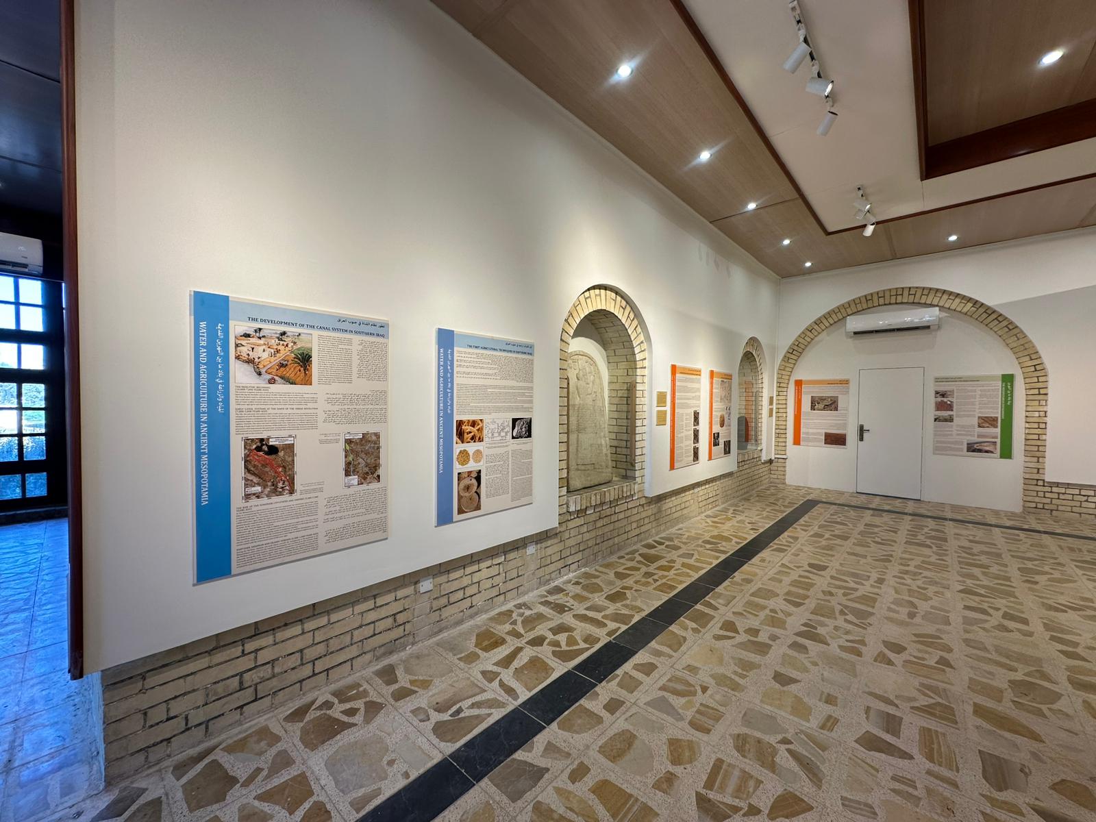
Fig. 1. The recovery and renovation of a section of an architectural landmark such as the al-Qishla complex provided an additional cultural space to the already-dynamic al-Mutanabbi district.
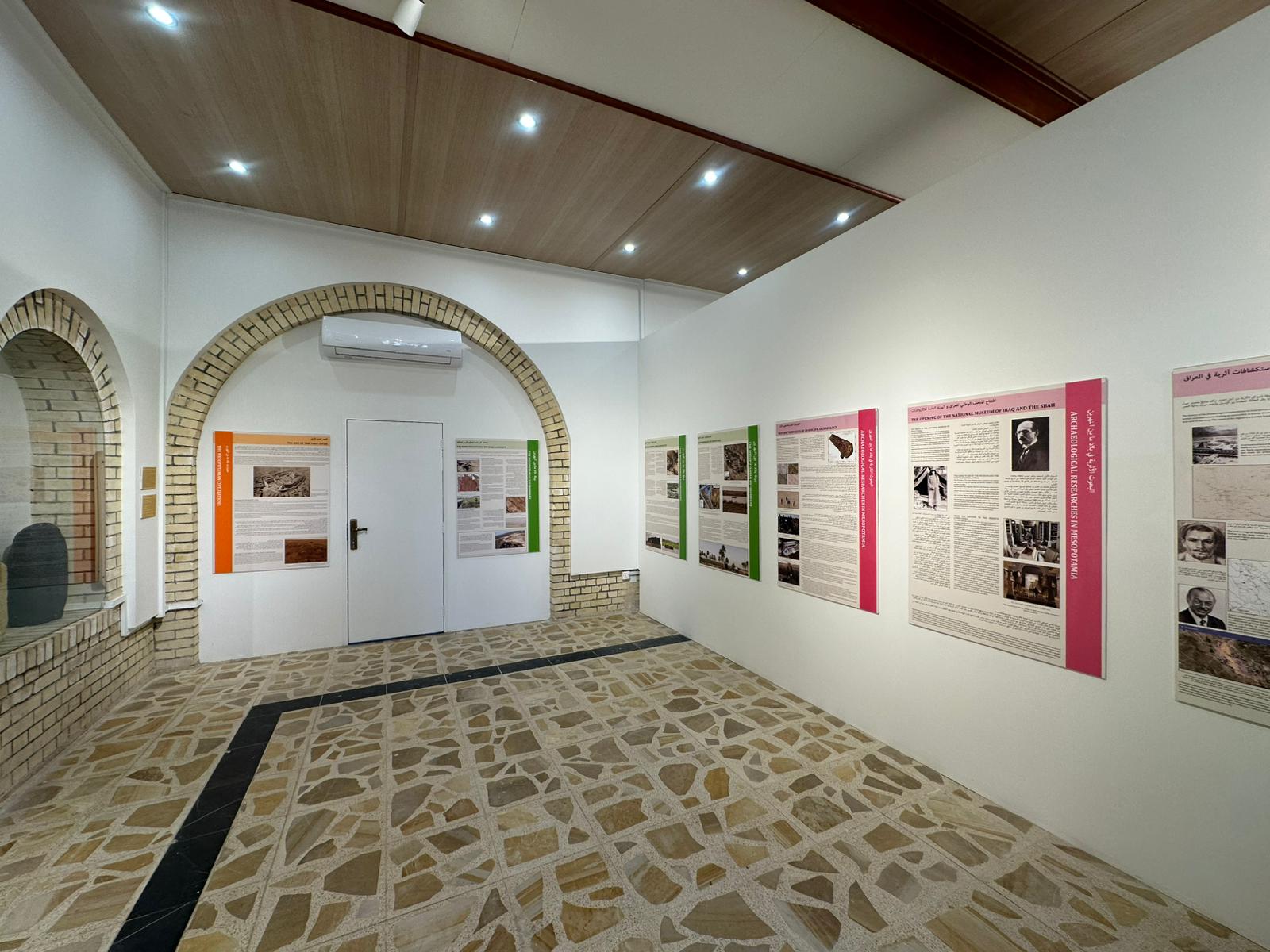
Fig. 2. The panels, distributed across 4 thematic areas, detail the ancient history and the current issues and threats affecting the Iraqi archaeological and environmental landscape.
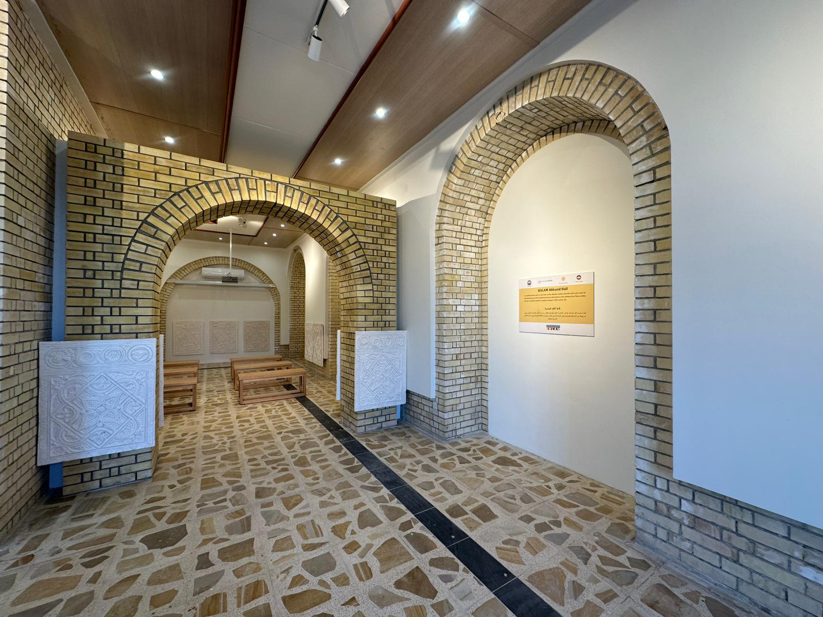
Fig 3. The renovation included the recovery of existing structures and the characterization of spaces according to traditional Mesopotamian and Iraqi architectural elements and styles.
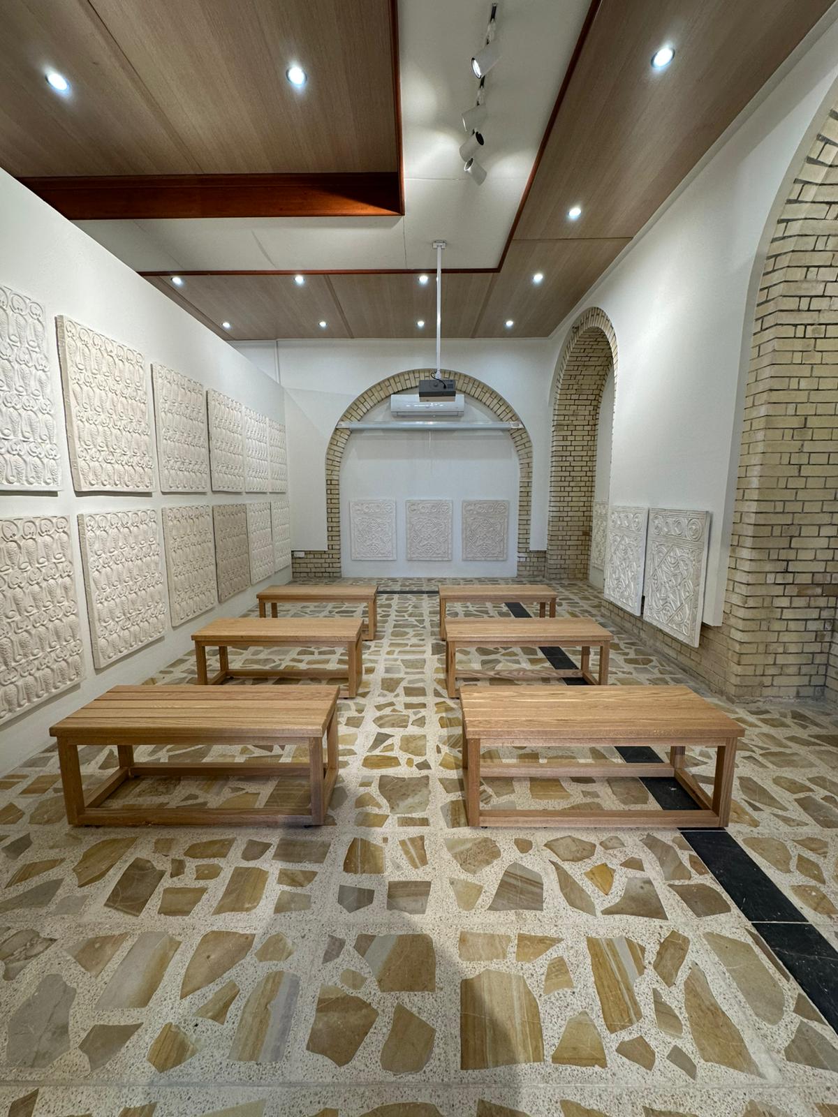
Fig. 4. One of the spaces, decorated with replicas of Abbasid-era stuccos, has been specifically arranged to host conferences and cultural initiatives for a wider use within the local cultural environment.
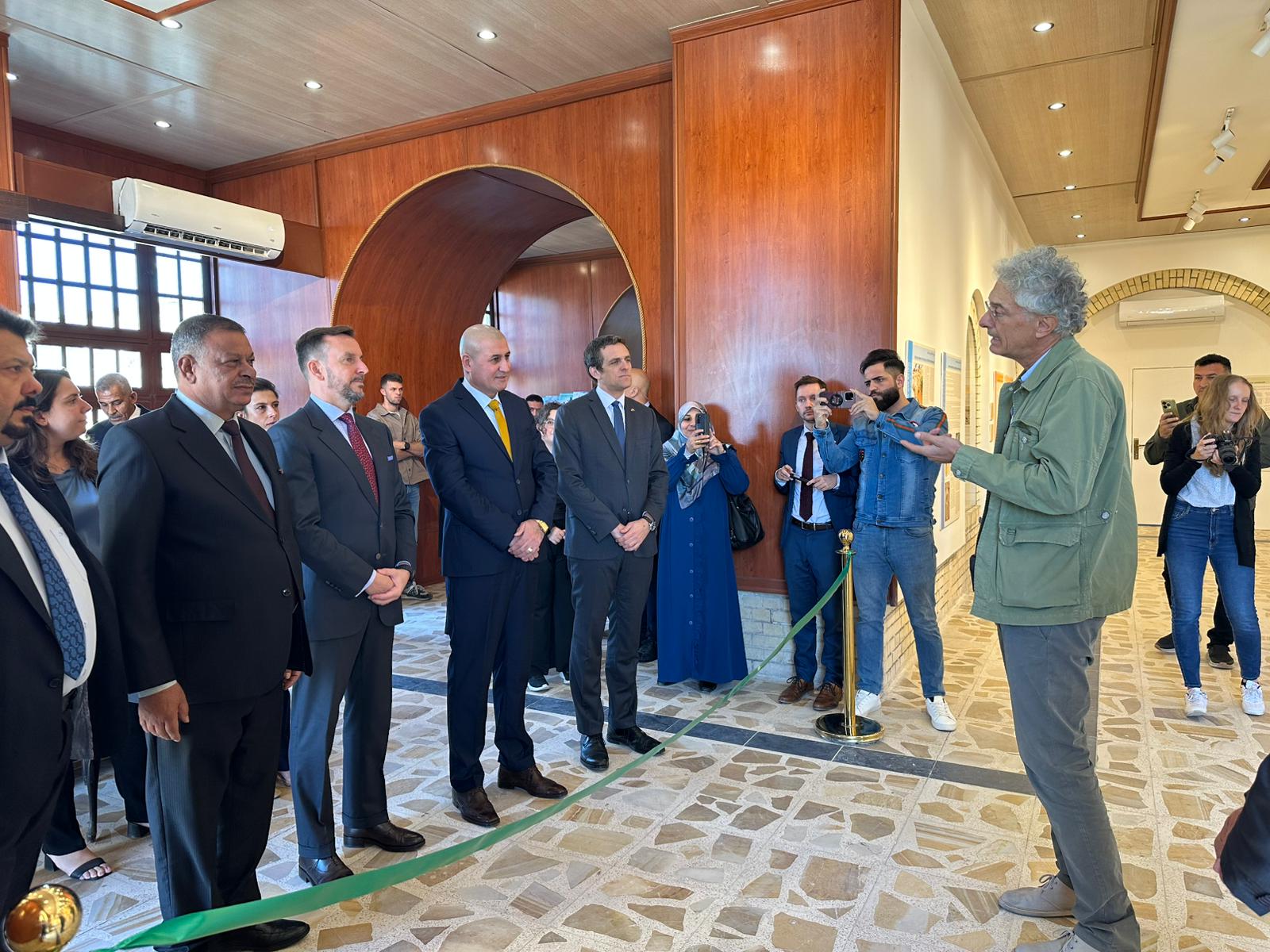
Fig. 5. The inauguration of the Museum Hall has been attended by Iraqi authorities from the State Board of Antiquities and Heritage (SBAH) and the Italian Ambassador to Iraq.
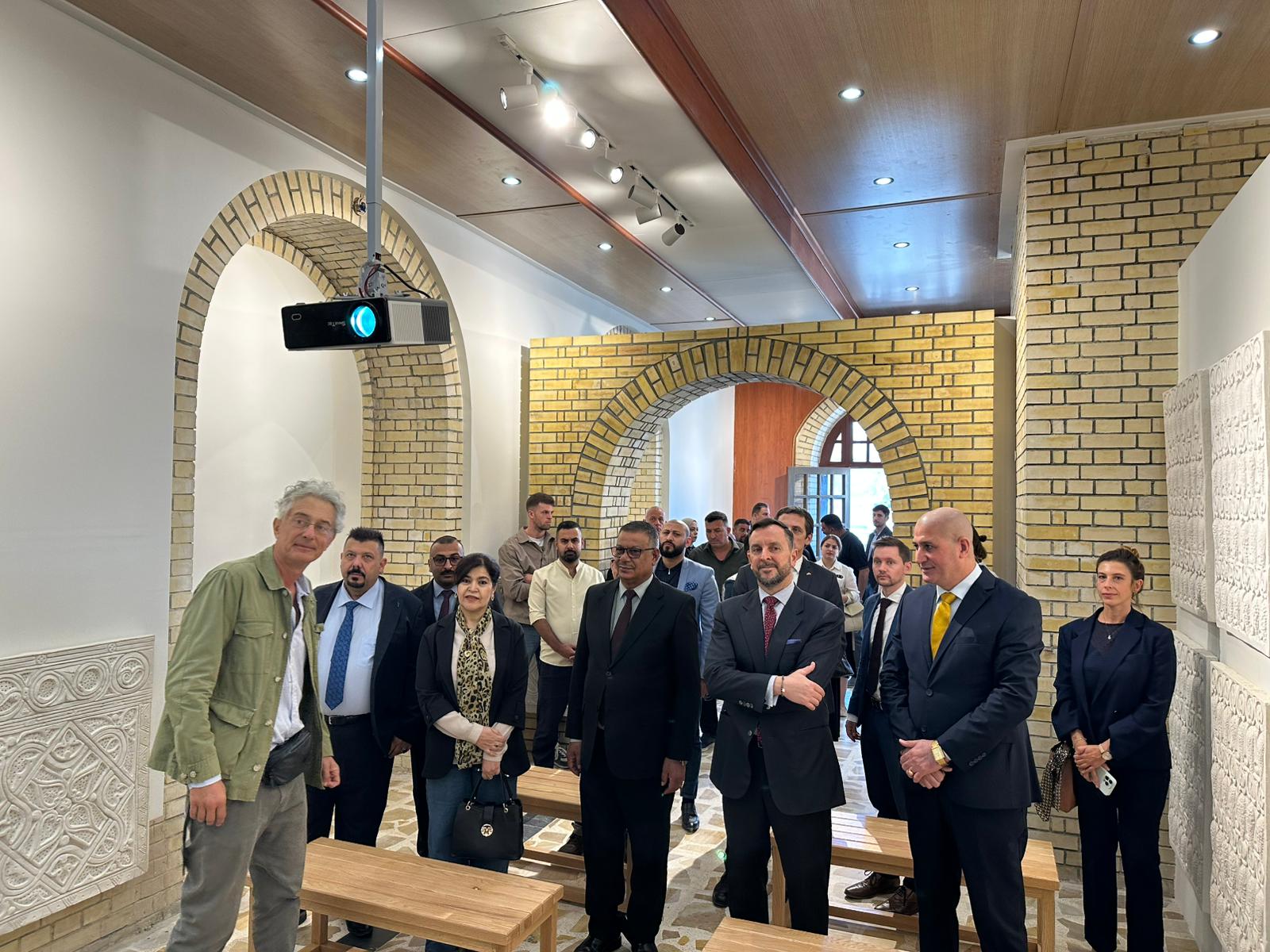
Fig. 6. The participation of components of the cultural community of al-Mutanabbi area to the inauguration event provided a positive impression for the sustainability of the Museum Hall in the longer term.
IRAQ - SELEUCIA-ON-THE-TIGRIS
An additional Visitors' Center has been planned and opened at the multi-mound site of Seleucia-on-the-Tigris, a main Hellenistic site located south-east of Baghdad within the Governorate, serving for both touristic and educational purposes for the schools in the area. The installation and refurbishing has been completed in November 2025: the inauguration was attended among others by the Italian Ambassador to Iraq, the Deputy of the Minister of Culture and the Director General of Museums of Iraq, together with representatives of the local community and the teachers and students of the local schools.
The event offered the chance to raise the awareness on the local cultural heritage through the presence of informative panels within the Visitors' Center and the opportunity to display the results and artifacts from the recent archaeological activities at Seleucia-on-the-Tigris.
Fig. 1. The Visitors' Center was created repairing and refurbishing an existing building in the area, located close to the local village.
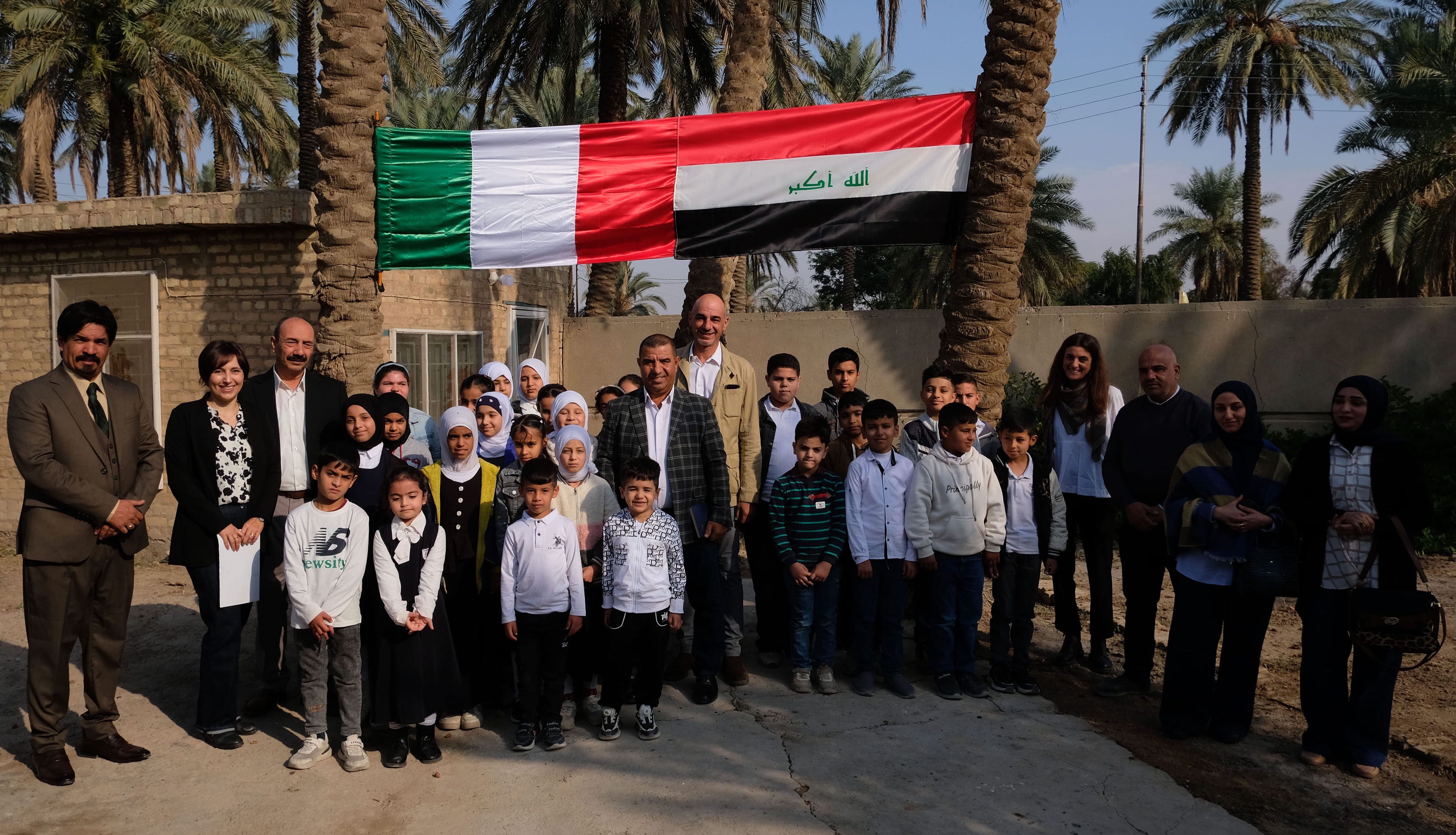
Fig. 2. The participation of students and teachers from the local schools has been significant to measure the potential impact of the Visitors' Center on the surrounding region.
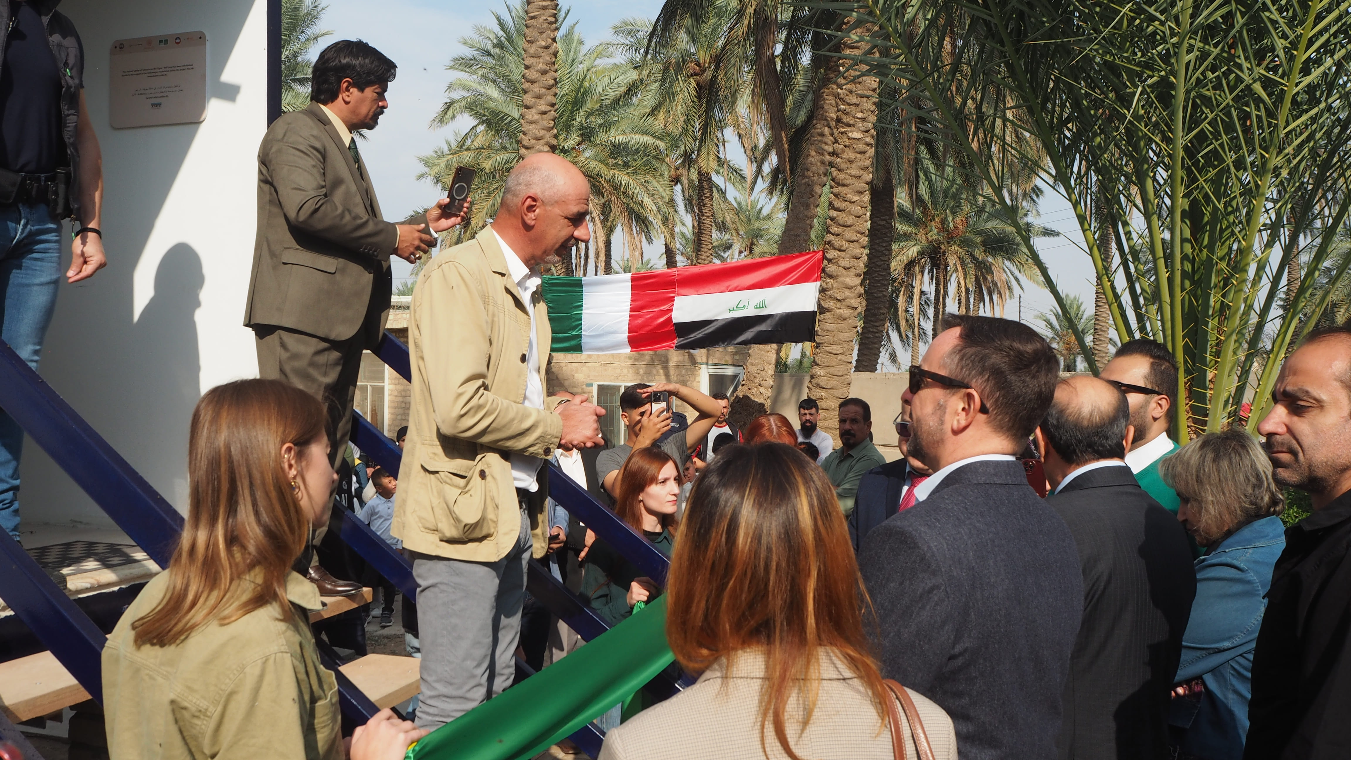
Fig. 3. The inauguration has been an important opportunity to underline the support of local Iraqi authorities and the Italian Embassy in Iraq.
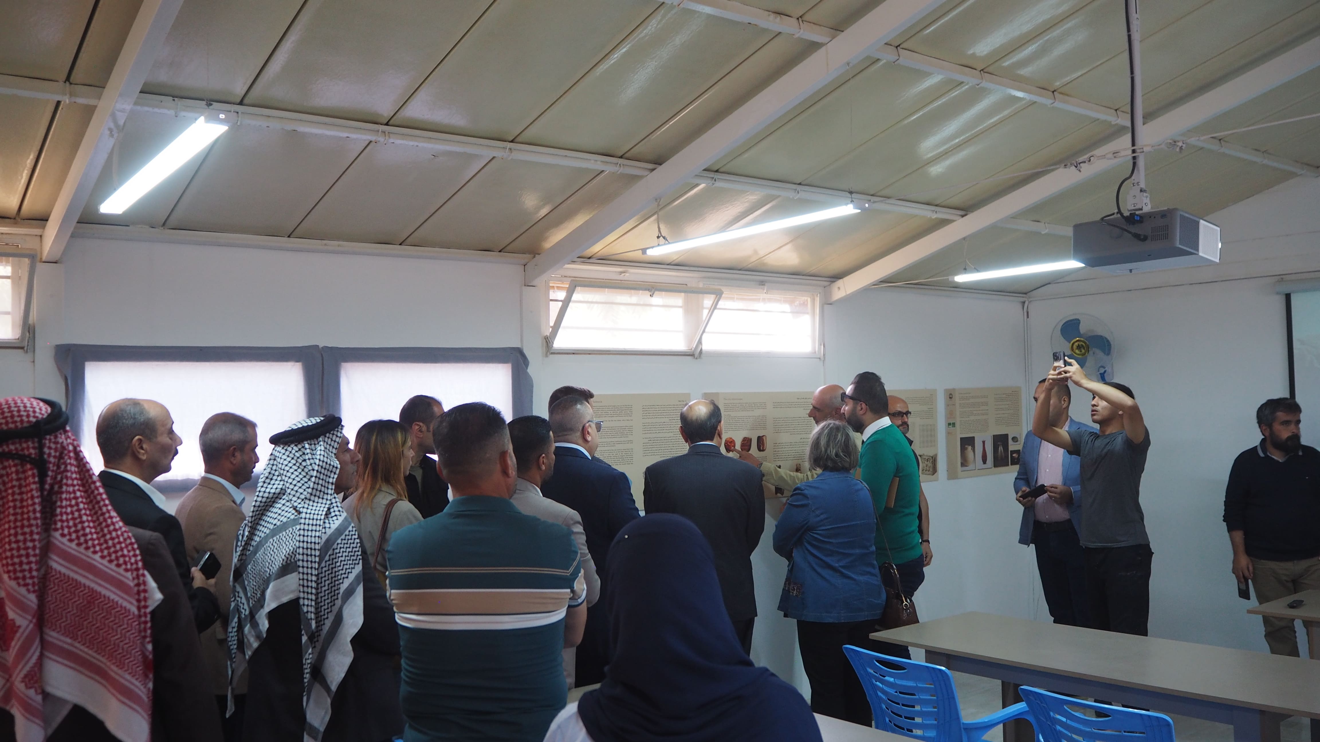
Fig. 4. The panels within the Visitors' Center illustrate the history and archaeology of the ancient metropolis of Seleucia-on-the-Tigris, including the discoveries from recent Iraqi-Italian explorations.
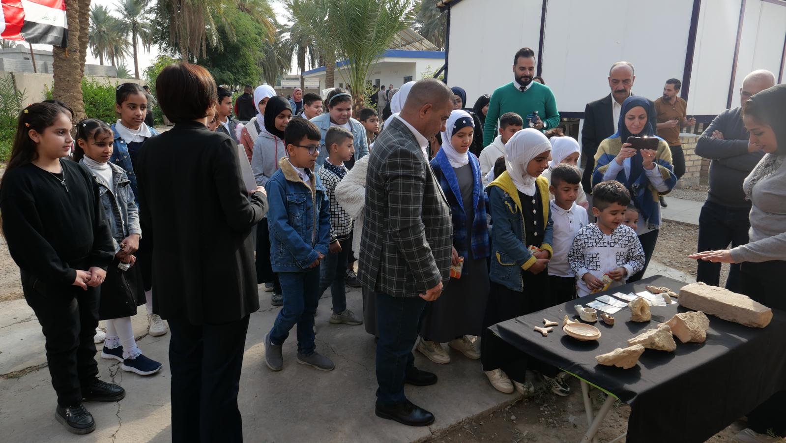
Fig. 5. The participation of students from the local schools has offered the opportunity to broaden the awareness on local heritage by reaching a larger audience.
A prototype of the mobile app for the documentation of the endangered sites and landscapes in Iraq has been developed: based on Epicollect5 (a free and easy-to-use mobile data-gathering platform), it is now available for both Android and iOS mobiles, it allows the recording of archaeological sites, their features and, in particular, the evident damages through textual descriptions and images (as photos taken with the mobile). The LMU team in charge of the development completed the English version and has already tested the prototype on the field in Iraq in April 2022. Meetings have been held in 2023 with the national direction of the SBAH to discuss on a permanent collaboration in order to implement the app as a standard tool for their personel in each regional inspectorate. For this purpose, an Arabic translation for the app is under way, thus enabling to reach the second testing phase with the Arabic-speaking communities. Bilingual videos on heritage will also be produced and disseminated through social media.

Fig. 1. The mobile app allows to record multiple information about the archaeological sites or landscapes, from distinctive features to potential threats and damages.

Fig. 2. The interface has been created to be user-friendly: data entry is possible through preset responses and it is possible to upload photos of the recorded features.
Uzbekscapes. Exploring water, heritage and community wonders in the Samarkand Oasis is the result of years of field research in the Samarkand province, carried out by a diverse group of contributors with different backgrounds and areas of expertise, all united by a common goal: to share the richness of Uzbekistan, and especially of the Samarkand oasis, by complementing its well-known tourist routes with alternative thematic itineraries. These itineraries offer the opportunity to explore and experience different landscapes marked by the presence of waterways and other environmental elements, cultural heritage and human communities.