

The activitites of Task 1.a "Preliminary assessment of archaeological elements through AI-driven remote sensing", entrusted to the UNIBO team, have been carried out through the close collaboration between the Department of Computer Science (Prof. Marco Roccetti and PhD candidates Luca Casini and Alessandro Pistola) and the Department of History and Cultures (Prof. Nicolò Marchetti and PhD candidate Valentina Orrù).
The task was framed as an issue related to semantic segmentation, a supervised learning technique that relies on skilled archaeologists annotating on satellite imagery the presence of artifical mounds in the surveyed landscape. This approach, which is not always viable being really time-consuming and expensive to carry out, has been adopted by the FloodPlains project, which provided an ideal dataset to challenge for AI-driven detection (around 5.000 sites within an area of 100.000 km2).
The geographical area under investigation has been divided into small overlapping tiles, classified as if containing a site or not. These tiles have been used to train models on a high-performative calculator (GTX 1080ti GPU with 11Gb VRAM) for 10 to 20 epochs, corresponding to roughly 30-60 minutes. The results have been quite positive during a first phase in 2022, with a value of approx. 70% of identified sites in the validation phase. Considering multiple variables (Dice Loss, Focus Loss) the mistakes have been minimal, mainly concerning low-quality images and sites located in critical contexts such as flooded areas.
These limitations (such as predicting False Positives and not recording some sites) have been challenged in 2023 through the adoption of image segmentation models with fully convolutional layers, overcoming input size limitations and granularity trade-offs. The dataset comprised geo-referenced vector shapes of archaeological sites in a selected 66,000 km² survey area, meticulously compiled from published surveys. Data pre-processing involved filtering, shingling, and adjusting input images. The sample area included 4934 shapes corresponding to confirmed archaeological sites. Filtering excluded excessively large or small sites, optimizing the dataset for model training. Input images were generated by extracting squares centered on site centroids. The chosen input image size was crucial; initial experiments used a length (L) of 1000 m. Increasing L to 2000 m has improved the overall performance. Random cropping, rotation, mirroring, and brightness adjustments augmented the dataset. Further down, CORONA imagery has been incorporated and different models for semantic segmentation have been explored. As result of these activitities, performance has improved notably with the increased input size and refined filtering procedures. CORONA imagery exhibited varying impact based on input size. Detection accuracy assessment has involved transforming raster predictions into vector shapes and evaluating intersection with site annotations. As a result of a workflow involving iterative model use, human evaluation, and dataset refinement for continual improvement, the current process of detecting archaeological sites has reached an 80% accuracy value.
Specific test areas for this procedure have been selected both in Iraq (Maysan Governorate), which showcased the model's ability to recover known sites and identify additional shapes, facilitating rapid evaluation by experts, and Uzbekistan (Zeravshan Valley), where testing the model on a dataset from the Uzbek-Italian Archaeological Project has revealed challenges in site detection due to landscape differences from Iraq. Transfer learning on a smaller, region-specific datasets was suggested for improved performance. Starting from early 2024, the team is currently engaged with model training on a new survey area related to the administrative district of Abu Ghraib within the Baghdad Governorate. The resulting projections will be validated directly in the ground during a field survey scheduled for January 2024.
Despite the challenges arisen in evaluating annotations' heterogeneity, the model's robustness and potential applications in automating surveyed areas were highlighted. The overall results of this methodology represent a major breakthrough, both theoretically and operationally. An exponential increase in data from further contexts will be seminal for evaluating the real settlement patterns and their historical impact on environment (at least those of floodplain types) and to providing protection and enhanced documentation for them.
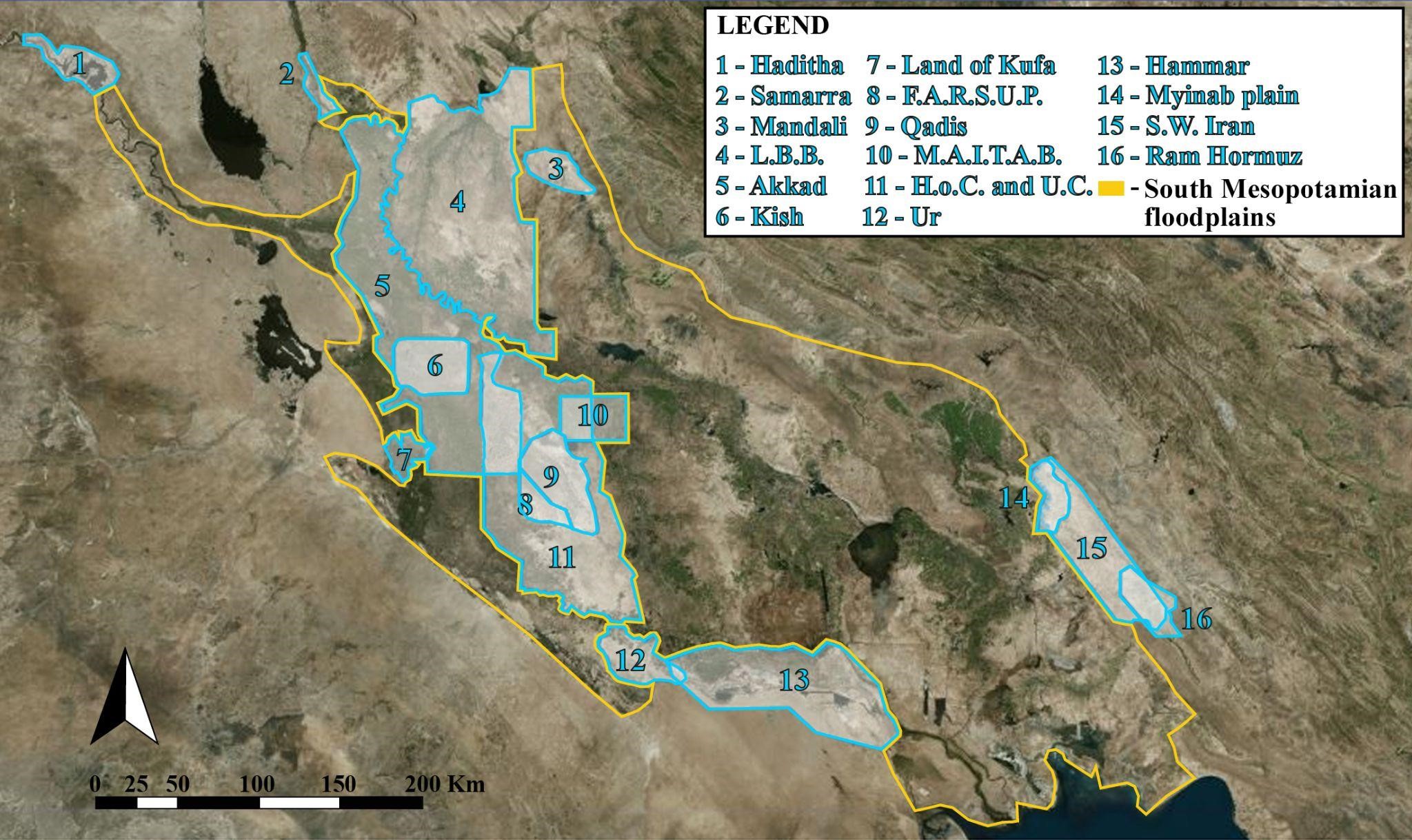
Fig. 1. A preliminary assessment of the available territorial data represents the first fundamental step for remote landscape analysis.

Fig. 2. The workflow combines different, scalar steps: a model is trained from annotated images and provides predictions masks. These masks can be used as an overlay or vectorized. Human evaluation is conducted on the outputs: in turn a refined dataset can be created to improve the model
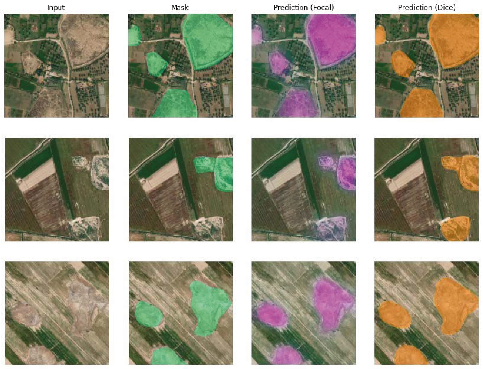
Fig. 3. Considering multiple variables, the mistakes by the AI-driven detection have been minimal and about 80% of sites have been recognised from satellite imagery.

Fig. 4. The developed model is now capable of matching accurately the outlines of the targeted sites, as seen from the minimal difference between the target mask overlaid on the input image and the prediction (the color bar corresponds to the classifcation probability).

Fig. 5. Maysan Governorate, with the main city of Amarah, is one of the main testing area for automated remote sensing of archaeological sites.

Fig. 6. The model has to be progressively tested in multiple landscapes between Iraq and Uzbekistan where different features and issues occur.
KALAM partners have acquired an extensive experience in archaeological fieldwork in different geographical and historical contexts, which represented the ideal areas where the project's methods and activities can be tested and implemented.
2022
IRAQ
UZBEKISTAN
2023
IRAQ
UZBEKISTAN
2024
IRAQ
UZBEKISTAN
2025
IRAQ