EDUU SURVEY OF THE EASTERN QADISIYAH REGION.
The fieldwork in Al-Qadisiyah was carried over two campaigns: in October 2017 and in January 2018. The UNIBO team worked in close collaboration with the University of Qadisiyah.
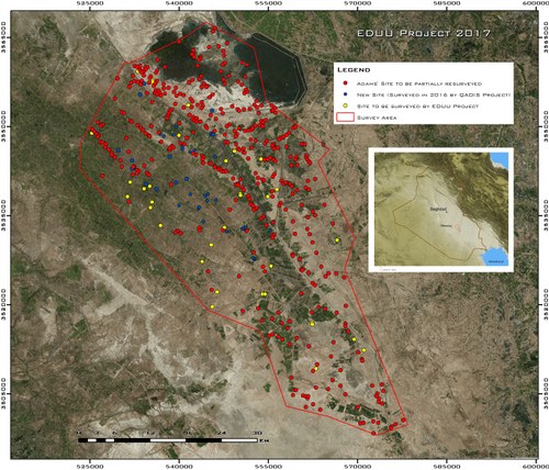
The Governorate of Al-Qadisiyah is a fertile alluvial plain located in southern Iraq and is one of the most important archaeological areas of the country and one subjected to intense cultivation. Early archaeological explorations focused on the sites of Fara – the ancient city of Shuruppak – and Bismaya – ancient Adab (1900s-1930s). Then, in recent years, the sites of Isin (Ishan Bahriyat) and Puzrish-Dagan (Tell Drehem) were also subjected to systematic excavations by foreign and local teams. The State Board of Antiquities and Heritage carried out several regular or emergency excavations. On the other hand, surface explorations lagged behind and the only systematic surveys carried out were the ones completed by Robert Adams in the 1960s-1970s.
Altogether, these explorations indicate that the area was a major urban core during most of the 3rd and the 2nd millennia BC, with an extended network of cities, villages and ramified waterways connected to herringbone cultivated fields. Of particular importance is the network of sites and waterways that can be dated to the Ur III period, when the dynasty that ruled Sumer from Ur (Tell al-Muqayyar in the Dhi Qar Governorate).
The main aims of this fieldwork activity were to produce a new understanding of a multi-layered historical landscape through cutting-edge documentation techniques. The methodological framework consisted of an integrated approach including ancient settlements and paleochannels reconnaissance through historical satellite imagery and free-access online platforms, high resolution photos of selected case studies taken with drones.
To do so, the EDUU team surveyed with modern techniques the settlements located in the area. The EDUU team targeted 40 sites that have never been surveyed before, identified thanks to satellite photos, that will be labelled as “EDUU Sites”. In addition, ancient channels, waterways and agricultural features were surveyed with an array of ground and airborne techniques, in order to reconstruct land-use patterns through time. Also, one particularly important site, Tell Abu Hatab - ancient Kisurra, a major urban center during the 3rd and 2nd millennia BC - was targeted by an intensive surface collection in order to ascertain its main occupational phases.
At the end of this fieldwork, the EDUU team gathered substantial data on the formation, growth and decline of ancient urban entities, their agricultural and pastoral strategies, the impact of states on economy and environment, religious and social identities. At the core of the project was the investigation of the dynamics between communities organized in towns, villages and the agricultural countryside they cultivated, in order to create a direct link between ancient and modern lifeways.
For more information, please dowload the attachment in the HIGHLIGHTS section below.
Go to the "Results" section for information on fieldwork outcomes.