Research programme and methods
WasteLands? foresees the application of diverse but complementary research methods to address the project’s objectives.
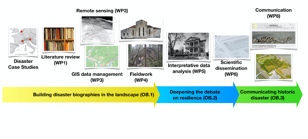
A detailed literature review will collect, integrate and map historical and archaeological information from published works. This dataset will generate a comprehensive and updated bibliographic repository for the selected historic disasters and will represent the starting point for the integration of fresh evidence collected by the project. New data will be captured through a remote sensing analysis, which will principally focus on vertical aerial orthophotos and LiDAR. Targeting topographical features generated by historic hazards, abandoned sites, and recovered and resettled landscapes, this research task will be crucial in detecting new evidence about the transformation of the landscape following the disaster. Fieldwork activities include site visit and documentation (survey), building archaeology recording, and consultation of local archives. These data will be essential to populate the project’s repository to be disseminated online. Building archaeology will be applied to study extant architecture affected by the disaster and later rebuilt or repaired. The stratigraphic analysis of the damage and the recovery will permit a better understanding of technological responses to the disaster, such as the adoption of mitigative architectural solutions, but will also provide data on the symbolic use of spolia in pre- and post-disaster structures. All the generated spatial data will be organised, explored and analysed with QGIS, a powerful open-source GIS integrating GRASS and SAGA module. The geographic data will be managed through a relational database capturing crucial information for each catalogued site. This will also facilitate spatial analysis. In order to enrich the theoretical debate on disaster and resilience archaeology, WasteLands? will target up-to-date social and interpretative approaches on post-disaster memory, ideology, power and inequality by adopting a multi-stranded theoretical toolkit and dedicated training in archaeological theory, cultural anthropology, and political ecology at Northwestern University. This research method will permit to shed new light on the dramatic landscape change which followed the selected disasters, particularly how we can understand and interpret the social meanings of the analysed evidence. The research will be informed and facilitated by wider theories and debates in anthropology and the human sciences, including historical and political ecology, the anthropology of risk and risk perception. The dataset will be searchable and designed to facilitate the download and use of information under the Creative Commons copyright. This tool will allow the project to reach a wider audience disseminating ‘the memory of the disaster in the landscape’ globally. Disaster Risk communication, strengthened by means of the project’s secondments, will be applied in the mounting of a 1348 earthquake exhibition and the preparation of flyers about the same event for primary and secondary schools in the Tolmezzo area within the INGV programme EDURISK.