

Panel l. Cityscape and pedestrian-friendly areas
Scale 1 : 10.000
We have identified 4 types of public space:

Such public spaces are necessary for travel, but usually do not provide any other use. Roads are mostly designated for travel and most of its surface is usually asphalt or other for vehicles. The more space for pedestrians and non drivers it provides the better value is the space.

The most common are slow traffic areas in city centers, and in neighbourhood centers. Pedestrians and bikers are privileged as well as public transport. The most common name for such a space is 'shared surface', because of different means of transport that share the area with reasonable speed.

These public spaces are usually designated only for pedestrians, and sometimes bikers may cross these areas.

These are probably the most valuable spaces in cities, since they are the most rare in urban landscape. Greenery provides microclimate, shade, lowers the temperature and purifies the air. Every green area and treeindense urban landscape are priceless.
Description of the mapping result: Most of the pedestrian-friendly public open spaces are located close to the city center. There are very few green spaces in the city center which is a shame, but outside the centre it is not better.
Panel la. City and density
Scale 1 : 20.000
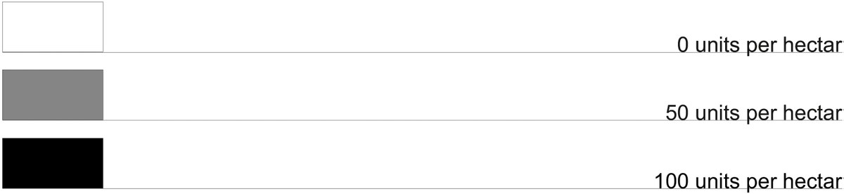
The density panel shows the intensity of number of units per ha. Housing density is an indicator, which reflects number of housing units (dwellings) per ha. The area of the Bologna city has been simplified to 91 squares which refer to 91statistical areas available in the Bologna spatial system. Density for each area has been calculated and set in a spreadsheet. A scale for 10 different levels of housing density has been set in order to organize a density drawing. Gradient level represents density: the higher density the more dense gradient. 100% represent 100 units per hectare, while 0% represents no units. The map shows the housing density of Bologna and refers to unite housing density measure. This indicator may be referred to theories and strategies on cities residential sustainability versus compactness.
Panel II. Cityscape and pedestrian-friendly areas, boundaries
Scale 1 : 2.000
The cityscape and pedestrian-friendly areas mapping in scale 1 : 2.000 shows the same data as in scale 1 : 10.000 but also reflects boundaries. Paving lines strengthen the drawing showing physical boundaries which sometimes have major impact on public space accessibility.

Such public spaces are necessary for travel, but usually do not provide any other use. Roads are mostly designated for travel and most of its surface is usually asphalt or other for vehicles. The more space for pedestrians and non drivers it provides the better value is the space.

The most common are slow traffic areas in city centers, and in neighbourhood centers. Pedestrians and bikers are privileged as well as public transport. The most common name for such a space is 'shared surface', because of different means of transport that share the area with reasonable speed.

These public spaces are usually designated only for pedestrians, and sometimes bikers may cross these areas.

These are probably the most valuable spaces in cities, since they are the most rare in urban landscape. Greenery provides microclimate, shade, lowers the temperature and purifies the air. Every green area and treeindense urban landscape are priceless.